Advertisement
Published: September 30th 2017

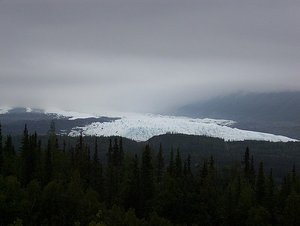
 Mantanuska Glacier
Taken fron the Glenn highway between Palmer and Glennallen. First glacier we saw in Alaska.Geo: 62.5718, -144.654
Thursday, 7/29/2010 – Drove to Slana on the Glenn highway and the Tok cutoff. Saw our first glacier, Matanuska Glacier, from the road en-route. Very impressive. Another impressive sight was the view of Mt. Sanford from the Tok Cutoff highway. We were headed for Nabesna Road, the northernmost road access to Wrangell-St. Elias NP.
Wrangell-St. Elias National Park and Preserve is the largest U.S. national park. At 13.2 million acres, it equals six Yellowstones. Mt. St. Elias, at 18,008 feet, is the highest in the park and the second highest peak in the United States. Four major mountain ranges, the Wrangells, the Chugach, the St. Elias, and the eastern end of the Alaska range, meet in the park and include nine of the 16 highest peaks in the United States. The Wrangells huddle in the northern interior. The Chugach guard the southern coast. The Saint Elias Mountains rise abruptly from the Gulf of Alaska to thrust northward past the Chugach on toward the Wrangells. The eastern end of the Alaska Range-mapped as the Nutzotin and Mentasta mountains-forms part of the preserve's northern boundary.
Stopped at the ranger station in Slana and inquired about the 
 Highway Graffiti
Saw a good bit of this along the highway in several places. Words & messages written on the banks using stones. Don't think I've ever seen that before.Caribou Creek trail along the Nabesna road. The ranger said the road was in good condition and that the trail was wet but trying to dry out. Drove to the trail head parking area through relatively flat terrain with a black spruce forest on either side of the gravel road and views of mountains in the distance.
We found the Caribou Creek trail to be fine for the first mile or so, but then it turned into one huge mud pit, mainly due to ATV traffic chewing up the trail. We tried walking parallel to the trail for another mile or so but finally gave up when the trail showed no improvement and the area adjacent to the trail was wet and boggy. We were not doing the tundra any favors stomping all over it and the mosquitoes were terrible, probably due to the wet conditions, so we returned to the road after only about 2 miles. We never left the mostly flat area but could see higher terrain in the distance.
Drove back to Rock Lake where we ate our late lunch and then hiked a short trail to a public use cabin. Nice cabin for backpacker use. Mosquitoes

 Mt. Sanford
Taken from the Tok Cutoff Highway. At 16,237 feet, Mt. Sanford is the sixth tallest peak in the US. The Sanford that this mountain is named for is no relation to the infamous SC governor of the same name. The mountain was named in 1885 by Lieutenant Henry T. Allen after one of his superiors in the war department.
were bad here too.
Drove back to Chistochina where we spent the night at the Chistochina B&B. Clean and comfortable place. The owners were a nice couple, Norma and Doyle, who, it turned out, spend their winters at the beach in SC. We stayed in the B&B's cabin which had a double bed in the bedroom and a sleeper sofa in the kitchen/living area. Only complaint was the bedroom/bathroom arrangement. The bathroom facilities shared the bedroom. Not a lot of privacy unless you closed the door from the living area to the BR. But this was one of the nicer places we stayed on this trip – we stayed in some really borderline places in Valdez and Seward. Rooms in the main B&B looked great. WiFi was available in both the cabin and the main B&B.
Advertisement
Tot: 0.097s; Tpl: 0.011s; cc: 16; qc: 27; dbt: 0.0267s; 1; m:domysql w:travelblog (10.17.0.13); sld: 1;
; mem: 1.1mb


