Advertisement
Published: March 31st 2008

 Bendigo
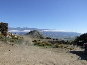
View from Bendigo to the Valley over a Mullock HeapWANANKA TO NASEBY VIA BENDIGO & THOMSON'S GORGE
It was time to leave Wanaka and the restful time we had had at Nancy and Chris's it is s shame that we didn't get to see them as Nancy is in Dunedin with Chris while he awaits a triple bypass operation, we hope to take some time out while we are in Naseby and go across to Dunedin to see them. I think from Naseby it is only about one and a half hours to Dunedin. Nancy had said to take some veggies from their wonderful garden so we picked some silver beet, spinach and zucchinis and checked for last of the summers red strawberries.
Our trip today will take us from Wanaka via Tarras to north of Cromwell where there is one of our favourite historic gold sites in the whole of the South Island. Bendigo, (a name borrowed from the well known gold mining town in Victoria Australia),Logantown and Welshtown all within a couple of kilometers of each other. We have been visiting this area each time we come south since taking the kids there some 10 or more years ago, on that occasion we had a Holden Station

 Bendigo
Miners Cottage ruinsWagon and we only just made it up the steep rutted gravel climb to the ruins. However once you arrive the site and the view would be worth it even if you had walked there. Bendigo itself is on he flat and was once the site of intensive Quartz Mining in the mid to late 1800's the information panel tells us that 28,400 ounces of gold was taken from here. The nearby Bendigo Station (Sheep not trains) was where Shrek the the sheep with the massive fleece was found in 2004.There is nothing left of Bendigo now, gold was originally discovered here in 1862 and miners flocked to the area from other goldfields nearby, initially it was easy alluvial gold that was found usually by simple panning and manual sluice boxes but as this gold began to run out the miners moved into the hills as they knew the source of the alluvial gold would be found in the quartz reefs in the hills. Nothing remains of Bendigo but it certainly is not standing still, the area on the flat and lower hills is covered with vineyards. Sheryll and I have spoken to Motor homers parked here before who come

 Bendigo
Miners Cottage ruinshere each year to work in the vines, the owner supplies an ablution block and a powered site for the workers, they all have a great time and cant waito to come back each year. Above them as you climb the steep hill you first come across the old school site in amongst the Pines, climbing further onwards to Logantown is the first site. An old mine shaft can be seen and the remains of the foundations of an ore crushing stamper. The main historic site is at the top of the hill at 3100 feet ASL here several of the mud brick houses still stand though without roofs, The corrugated iron of the roofs has long rusted and been taken by the winds to places miles away probably. How ever the mud bricks made by the miners with clay from the streams, mixed with chopped tussock grass then baked in the sun to dry still stand, some of the huts were made of slabs of schist rock stacked to build a wall and mud and gravel used as a mortar to draught and weather proof them. One cant help thinking what a rugged existence this must have been at
3100 feet with snow and iccy conditions to deal with, working down vertical shafts some of which were as deep as 178 meters.
The miners that came to Bendigo initially abandoned their claims in other areas one of those was called Tinkers (now known as Matakanui it is about 35 kms away over the Dunstan Mountains via the "Thomson's Gorge", how could I resist another trip over this 4WD track with such a great name, along he way you pass the "Come in Time" Battery off on the right and side of the road. The Department of Conservation have recently restored this battery and there is a 60 metre horizontal mineshaft nearby to explore. The trip over Thomson's Gorge rises to about 3000 ft as well and as you descend to the Matakanui side there is amazing views of the Manuherikia Valley and Blackstone hill and North Rough Ridge in the distance. We stopped in at Tinkers to see the old abandoned hotel and an old sluicing gun. A few k's down the road is the Drybread cemetery, nothing remains of what the town was, just the cemetery, the headstones tell some sad tales of very early deaths through accidents
and drownings on he gold fields. We arrived late at the Larchview Motor camp to find our dear friends Ray & Shelly from Cable Bay in the Far North had been wondering where we were. Lots of chats and plans being made for the next few days together in the Naseby area.The Larchview Motor camp is set amongst a mature stand of trees, mainly Larch and untill Tracey and Matt purchased it about 3 years ago had been getting rather run down. Naseby only has about 80 permanent residents but this swells to about 3000 during the Summer
pleased to say that the camp is now being renovated and Tracey and Matt are doing a great job, we thoroughly recommend a relaxing stay here. Naseby's motto is "2000 ft above worry level", How True.
Advertisement
Tot: 0.041s; Tpl: 0.011s; cc: 8; qc: 23; dbt: 0.0223s; 1; m:domysql w:travelblog (10.17.0.13); sld: 1;
; mem: 1mb


