Advertisement
Published: March 24th 2008

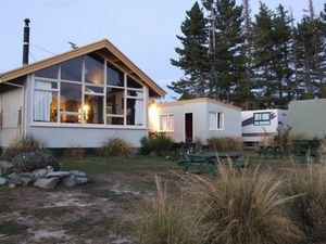
 Early Morning at the Hostel
Early Morning at the HostelThe view from our window at the hostel was superb and we were both up early enough to see the sun rise over the ranges and bathe the lake with a soft pink glow.
Mt John is about 800 m above the Village of Tekapo, the Mt John Observatory is operated by he Canterbury University and is at the very top. Apparently it is one of the few places in New Zealand where the atmosphere is clear enough and where there is no interference from the lights of a town to make it possible to view the stars by huge telescopes. it only operates at night so we not able to star gaze but we took the drive to the top of Mt John just to see the view, a full 360 degrees of the Mckenzie Basin, Mt Cook in the distance, (managed to get a picture of that) and all the way to the Godley Range at the head of the lake. as we were there early there was no heat haze as yet so great opportunities for pictures. It is difficult to show the perspective of the height above the lake in these photo's. Just below Mt John is

 View from our window at sunrise
View from our window at sunrisea smaller lake, Lake Alexandria which has a small community of about 20 bach's (note for Canadian viewers - see the word is spelt correct it is even on the name plaque) and a domain motor camp for about 20 tents or caravans, we decided to explore the area as from the top of Mt John it look fascinating, being Easter there was several families there with their children, lots of dinghy's and ducks and most of all great reflections of the ranges in the calm lake water.
The trip from here joins up with Lake Pukaki, a man made lake for hydro electricity generation purposes and the waters of Pukaki have a milky blue colour similar to Lake Tekapo, this is caused by the waters that feed the lake from the glaciers above them, the colour is caused by the glacier grinding the rock to a very fine flour like substance and it stays suspended in he water. gives a magic effect in photographs, this is about as close s we will get to Mt Cook so a photo stop here for a shot up Lake Pukaki to Mt Cook in the distance wa called for.
A short distance

 Lake Alexandria below Mt John
Lake Alexandria below Mt Johnon we came across the "High Country Salmon Farm", these salmon are farmed in the Hydro canal waters, you walk out on pntoons to the holding pools and can feed the fish. Sheryll is very fond of Salmon so we bought a small amount of smoked salmon which they put on ice for you. Sheryll has enjoyed this for the last few days on crackers and also at night with our main meal.
Along this section of our trip we both had read about some interesting places we wanted to visit, mine was the first to come up, just plainly referred to as the Clay Cliffs just north of Omarama. The cliffs are on private property off Quailburn Road, after making the obligatory $5 donation in the box at the gate, we bumped along a dusty farm track to the car park and then hiked along a track to the cliffs. Once again another of those places that are so hard to photograph, the cliffs just rise vertically beside you, they are of a soft material and obviously become eroded in wet weather by the amount of material on the valley floor. The area was not well known, though a

 Mt Cook in the distance from Mt John
Mt Cook in the distance from Mt Johncouple that we met there from Belgium said they had read about it in the latest Lonely Planet guide book, so I guess the world will know about it soon. Wouldn't mind the $5 donation from all of those people myself. (Lin have you been here before ? An amazing area for those interested in geology.)
The river that runs beside the area was the Ahuriri and this was Sheryll's special place that she wanted to visit. We had to track back the way we had come then onto the small town of Omarama and then about 20 k south to the turn off to the Ahuriri Conservancy area. we could see the cliffs we had just come from across the river but had traveled about 30 k to get to where we were. The Ahuriri area is a recent addition to Department of Conservation land ownership after High Country Sheep Station tenure review. It certainly is a lovely area . We stopped at the Ahuriri Base Hut, an old ex Forestry Service Hut to have a very late lunch at about 4pm.
We arrived in Wanaka at about 6pm and settled into my cousin Nancy and Chris's home. Nancy

 Mt John looking towards the Godley Range
Mt John looking towards the Godley Range at the head of Lake Tekapois away in Dunedin where Chris is in hospital for an operation. A long day with lots of walking but great fun.
Advertisement
Tot: 0.046s; Tpl: 0.012s; cc: 7; qc: 26; dbt: 0.0253s; 1; m:domysql w:travelblog (10.17.0.13); sld: 1;
; mem: 1mb


