Advertisement
Published: September 18th 2018

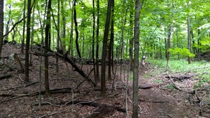
 Deming Hill Trail
This is the trail we started on to Deming Hill in NY. The trail was very muddy and wet in places with lots of mosquitoes so we turned back. Notice more of the stone walls seen on other hikes.On Wednesday morning, we left the motel around 8:00 AM and drove south into New York state. We checked out one trailhead around Garrison, NY, that went to a viewpoint called Deming Hill but the AT here was overgrown and traversed a marshy area with tons of mosquitoes. After hiking about a half mile fighting the bugs and humidity, we decided to turn around and go to our second choice – Anthony’s Nose. Anthony’s Nose is a rocky outcropping just above the Hudson River overlooking the Bear Mountain Bridge. The AT crosses the Hudson River here along that bridge. We parked at the base of the ridge that the viewpoint is located on and hiked the AT northbound for about a half mile – straight up. You only gain about 500 feet in that half mile but boy is it steep! Near the top of the ridge the trail to Anthony’s Nose splits off to the right with the AT continuing on to the left. We hiked on to the nose for the views and to eat lunch there. Returning to the car, we had only hiked about a total of 2 miles with only 1 of those on the AT,

 Anthony's Nose Trail
The climb to Anthony's Nose.but we had technically met the requirement of hiking on the AT in New York state. We would get one more hike on the AT in NY on Friday so we actually did a bit more than the one mile in NY.
Returning to our car, we drove on to our next motel in Greenwood Lake, NY, just north of the NY, NJ state line. This motel, called Anton’s on the Lake (never met Anton) was the worst one we have stayed in for a very long time. In hindsight we probably should have asked for our money back and gone somewhere else. Even if we couldn’t have gotten our money back we should have gone elsewhere – but we toughed it out. Suffice to say that problems were numerous – room wasn’t ready until almost 5:00 PM, the bathtub nozzle fell off while trying to take a shower, the handle to the water control for the shower/tub fell off, the microwave did not work, the A/C spit water into the room, etc. However, the hikes we did from here were pretty good.
On Thursday we did our AT hike in New Jersey to

 Bear Mt Bridge
This bridge is called the Bear Mt bridge after a summit nearby in NY, not the same as the one we climbed in CT.high point called Pinwheel Vista in the Wawayanda Mountains. From the Appalachian Trail Boardwalk trailhead on state highway 517, McAfee Glenwood road, just south of the NY, NJ state line, we hiked about 2.5 miles of relatively flat off and on boardwalk that took us across a marshy or boggy area, a creek with a suspension bridge, a train track, and a muddy meadow with lots of cows and to a second trailhead at state highway 93. From this second trailhead, we had to start climbing in earnest gaining about 1,000 feet in the next 1.5 miles to the viewpoint overlooking the valley where we started our ascent. This steep section of the trail is called the “stairway to heaven,” a series of rock slab steps that steeply switch-backs up Wawayanda Mountain to a short side trail to the viewpoint. I’ve looked all over the internet to see why this place was called Pinwheel or Pinwheel’s Vista but can’t find it. If anyone knows where the name comes from, please let me know. Anyway, the hike was quite a workout but with a pretty nice view as a reward. Thankfully this was the last of several steep rocky climbs we

 Selfie
On Anthony's Nosehad on trails on this trip. After a leisurely lunch atop the rocky overlook, we retraced our step back to the car, finishing with about 7.5 miles of the AT in New Jersey under our boots.
Friday morning we checked out of Anton’s, vowing to write a scathing review on Trip Adviser, and drove to the trailhead for our last hike before continuing on to the airport in Connecticut. Our final hike was to a place called Cat Rocks (had to do this one) in New York just north of Greenwood Lake and the NY, NJ state line. At only 3.6 mile round trip with only a little over 500 feet in elevation gain, this hike was relatively easy compared to most of the others we did on this trip. Most of the elevation was gained in the first half mile so it was a little steep for a short distance but no huge rocky climbs on this one until we got to the Cat Rocks themselves. There we did have to scramble up a short climb to the top of the rocks for some nice views of the countryside. The rocks themselves were pretty impressive even

 Lunch
Lunch
Our lunch spot on Anthony's Nosewithout the views. Returning to our car, we took off our hiking boots for the last time on this trip and headed for our motel near the airport, a Hilton Garden Inn that was 5 star luxury compared to what we had left at Anton’s. After a good, though short, sleep we were up very early to catch our 6:00 AM flight home. Got to GSP around noon and on to home and the cats about 2:00 PM.
Advertisement
Tot: 0.083s; Tpl: 0.013s; cc: 15; qc: 30; dbt: 0.0319s; 1; m:domysql w:travelblog (10.17.0.13); sld: 1;
; mem: 1.1mb


