Advertisement
Published: June 22nd 2017

 IMG_7418
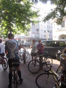
Our driver and navigator. Was my taking this photo mere coincidence?No time to write today, had a bit of an adventure getting lost by following the right road?? It's almost 10PM as I write this and will go to sleep soon. hope to catch up tomorrow.
Updated June 23 Where to start? The day began with a lovely al fresco breakfast topped off with a canoli courtesy of Dan while we assembled early in the shade hoping to get away before the day heated up too much. My original intention was to make this an easy transition day as we started the second half of our journey, and I figured I might add an additional loop at the end if I felt strong, but after a discussion with route-master Tom I opted instead to do an extra loop beforehand inasmuch as it was presented as a relatively easy climb that would afford good views of the lake from on high, whereas the later loop apparently just followed a gorge.
We all rolled out of town together and when we hit a red light at a roundabout I asked Tom if that was where I should turn for the climb to Le Semnoz, there being far too many

 IMG_7420
Canoli power!signs to read; "not this one - straight through" was his response. We continued on for several kms on the narrow road filled with cars (why we weren't on the bike path where we should have been, I once again had no idea) before stopping once more, at which point I confirmed that my earlier suspicions had been correct and indeed upon retreating to the previous roundabout I saw that the very last sign on the pole indicated the route to Le Semnoz. I didn't realize it at the time, but this minor snafu was but a harbinger of things to come.
There was a bit of a climb to get to the road that led to Le Semnoz, at which point my plans for a leisurely transition were immediately kyboshed: the 16km journey started with km-average grades listed (this time I made sure to read the placards inasmuch as they were on my side of the road) as 6%, 8%, and 7%. When km 4 appeared at 4% I assumed the worst was over, and indeed the next few kms were listed at 3%, 3%, and 5% - although one has to remember these are averages: the very

 IMG_7422
Leaving Annecy (we should be on the path)spot where the 5%!g(MISSING)rade was announced proved to be the toughest section I had met yet. Of course that wasn't to last - subsequent kms checked in at 8%!,(MISSING) 9%!,(MISSING) 10%!,(MISSING) 9%!,(MISSING) 8%!,(MISSING) 8%!,(MISSING) 9%!,(MISSING) 9%!,(MISSING) and 8%!t(MISSING)his was one tough climb! Not only that, but when I got to the top I discovered
• All I really got was a better view of the haze
• In any case the most scenic viewpoint was just before the summit, and having discovered this I was not about to descend for a better photo.
Things didn't look like they were going to get any better when I discovered that the top part of the descent was rough and pebble-strewn, but that eventually gave way to glorious long, sweeping runs on smooth pavement connected by equally-smooth switchbacks and affording great views of the valley. Of course such conditions allowed for very high speeds, which means I didn't stop for any photos. Until I hit the final 2km of freshly-spread gravel that led into the Col de Leschaux (which I actually descended to rather than climbed, and that is why I didn't take an Obligatory Col Shot there).

 IMG_7425
This local blew by me on a hill; I noticed he wasn't even in his lowest gear (but maybe he knew the grade relaxed just ahead)Continuing to descend, I made a side trip to the "artisinal chocolate" shop mentioned in our route notes but found it overpriced for what it was (OK, but nothing spectacular), but I did at least seize the opportunity to fill my water bottle. Thus fuelled and hydrated I set off for another side trip to the Pont de l'Abime, which had been billed as being "way up" and offering "great views". I found it not worth the 1km I had to descend and then climb back up from. This was after having laboured up a wobbly road whose irregular surface made generating any sort of speed almost impossible, but at least the signs warning of gravillon seemed to have been mistaken, and eventually the wobbliness disappeared and I could resume cruising.
Turning off onto the road to Montcel I was surprised to have to climb again (I guess the name might have been a tip-off) but did find a cool stump on which to sit and have lunch. Need I mention it was ridiculously hot again?
The climb through the heat was eventually rewarded with what would have been an enjoyable ride down but which had to

 IMG_7427
Art shot #2be interrupted because the car ahead of me kept slowing in the turns, But that was nothing compared to the traffic I encountered when I reached Chambery, where cars were at one point completely stopped bumper-to-bumper as I sought to pick my way through town with the directions I had.
It was here that - how gingerly can I put it? - a successive combination of circumstances conspired to eventually find me heading in the right compass direction on the right highway yet getting further and further away from my desired destination. Even when I had a sense something might be wrong and stopped to consult at the Tourist office in Challes Les Eaux to confirm things, my error did not get noticed/corrected by the young woman there, and when I did eventually reach the distance at which I should have noticed a significant tunnel (but didn't) and realized I was off course, consulting my map (or at least the snippet included in our directions) showed that there were indeed 2 branches of route D1006 that ran south from Chambery and since I had a river on my right and the top part of the map showed the words

 IMG_7428
The final km at last (8%)Challes (if not the town itself) it seemed like I was simply descending the 'wrong' one (think of it as U-shaped). I thus thought I could continue until I reached the bottom of said U, at which point I would intersect our route, make the turn onto a different highway and proceed as if nothing had happened.. And so I pressed on.
It was not a very enjoyable ride. The highway was narrow and heavily-trafficked with lots of trucks, and it passed through mainly industrial areas so I was relieved when I finally saw in the distance the bridge that I thought would take me across the river to the 'other' part of the highway. When I got there, however, I discovered that the town names on the signs still bore no resemblance to what was on my directions,. After trying to make sense of things I consulted with a motorist who emerged from a one-lane bridge and discovered that I was nowhere near where I thought, and eventually ended up going onto a hardware store in a nearby town (Chamousset), where the proprietor graciously tried to help me out.
It turned out that I was on yet

 IMG_7429
The view from not-quite-the-topa 3rd section of the highway that ran south-ish from Chambery, and had managed to get myself about 60-80km away from where I should have ended up. He let me use his phone to call our van driver, and after doing some route research we agreed that I would pedal north about 15km back to Montmelian where I would be picked up and driven to Voiron.
We got in at about 7:30. It had been quite a long day and I was very hungry.
Advertisement
Tot: 0.16s; Tpl: 0.012s; cc: 5; qc: 45; dbt: 0.0892s; 1; m:domysql w:travelblog (10.17.0.13); sld: 1;
; mem: 1.2mb


Incila
non-member comment
Kudos
Mark, After logging in, reading your blog was way beyond educating and entertaining compare to smartphone. Thank you for your extra time answering my questions about your trip. The thing that I am most curious about is how many calories you consume every day that you ride. Can you make a food list that you eat a day? Actually, I would like to know it for every single day but I know this would be too much work and time to spend in front of the computer. All my best