Advertisement
Published: September 29th 2016

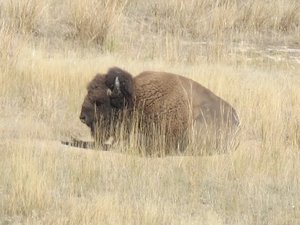
 Old Bison
He was alone in another part of the park, away from the herd.We left Coram on Tuesday morning, where the temperature was 38 degrees, and drove south along Flathead Lake. I had found an interesting first stop at the Kerr Dam overlook in Polson at the end of the lake. Well, we never found either the overlook or the dam and Bill was not happy about making a fruitless 40 minute detour...
My next stop was to be the National Bison Range. The GPS had it listed so we were certain to find it. However, the GPS had it marked incorrectly, and we were just about ready to give up, when it came into sight! I was very happy to avoid another useless quest... It had gotten much warmer by midday, with the temperature nearing 90 degrees!
"The
National Bison Range (NBR) is a
National Wildlife Refuge located in western
Montana established in 1908 to provide a sanctuary for the
American bison.
[ The NBR is one of the oldest National Wildlife Refuges in the United States. The size of the bison herd at the NBR is relatively small, numbering between 350 and 500 individuals. The initial herd of
American bison was provided by organizations such
as the
American Bison Society, and today the refuge serves as the central point for bison research in the United States. The NBR consists of approximately 18,800 acres and is managed by the
U.S. Fish and Wildlife Service.
Once believed to number in the tens of millions, bison once were found in all the current U.S. states, except Hawaii, and also throughout
Canada.
Bison were nearly extinct by 1890, having been part of a Federal government sponsored program of eradication during the Indian Wars, thereby removing a vital food source from the Plains Indians diet, and ensuring easier relocation onto Indian reservations."
After a great driving tour of the Bison Range, we continued southeast through Missoula and across Lolo Pass into Idaho, stopping at Travelers' Rest for lunch:
In the summer of 2002, archaeologists uncovered evidence of the Corps of Discovery's visit to the area, including a trench latrine tainted with mercury, fire hearths, and lead used in the repair and manufacture of firearms. The discovery makes Travelers' Rest the only campsite on the Lewis and Clark Trail with physical evidence of the expedition. For centuries Native Americans also used the area as a campsite and trail junction. Salish, Pend d'Oreille and Nez Perce peoples were
among those who traditionally occupied the area.
We drove along the Lochsa and Clearwater rivers from the pass to Lewiston, where they join the Snake River. There is a lot of of very sad Nez Perce history along this route.... We spotted smoke from several forest fires, but didn't come close to any.
We spent the very warm night in Lewiston (with too much traffic noise, but good Mexican food!), and got a pre-dawn start the next day for our final leg of the trip through Washington.
Our first stop was the beautiful little historic town of Pomeroy. The
Nez Perce trail existed in the area before history was recorded, and the first written record of caucasians passing through the area were
Lewis and Clark in 1805 Pomeroy was officially incorporated on February 3, 1886.
When we crossed the Snake River near Lyon's Ferry, we were amazed to see a small cruise ship in the bay at the junction with the Palouse River. Further research informed us that many cruise companies operate boats from Portland to Clarkson!
We drove northwest to see Palouse Falls at dawn. This is one of my favorite places in all of the West...it's

 National Bison Range
There is a herd about half way up in the photo..black dots in the grasslands...beautiful and I love the geological stories here. At the end of the blog I'll add more about the Great Flood whose path we followed on the last two days of travel.
We stopped at the old mining town of Liberty on our way north and then took the old Blewett Pass road up to Highway 2. It is mostly one lane due to the vegetation encroaching the road. We saw no other cars until we were almost to the end! We crossed Stevens Pass back into Western Washington and then north to the Skagit Valley and home
Flood Facts: • The ice dam was over 2000 feet tall.
• Glacial Lake Missoula was as big as Lakes Erie and Ontario combined.
• The flood waters ran with the force equal to 60 Amazon Rivers.
• Car-sized boulders embedded in ice floated some 500 miles; they can still be seen today!
About 12,000 years ago, the valleys of western Montana lay beneath a lake nearly 2,000 feet deep. Glacial Lake Missoula formed as the Cordilleran Ice Sheet dammed the Clark Fork River just as it entered Idaho. The
rising water behind the glacial dam weakened it until water burst through in a catastrophic flood that raced across Idaho, Oregon, and Washington toward the Pacific Ocean. Thundering waves and chunks of ice tore away soils and mountainsides, deposited giant ripple marks, created the scablands of eastern Washington and carved the Columbia River Gorge. Over the course of centuries, Glacial Lake Missoula filled and emptied in repeated cycles, leaving its story embedded in the land.
Much of the National Bison Range was once under prehistoric
Glacial Lake Missoula, which was formed by a glacial ice dam on the Clark Fork River about 13,000 to 18,000 years ago. The lake attained a maximum elevation of 4,200 feet, so the upper part of the Refuge was above water. Old beach lines are still evident on north-facing slopes. Topsoil on the Range is generally shallow and mostly underlain with rock which is exposed in many areas, forming ledges and talus slopes.
The ancestral Palouse river flowed through the currently dry Washtucna Coulee to the
Columbia River. The Palouse Falls and surrounding canyons were created when the Missoula Floods overtopped the south valley wall of the ancestral Palouse River, diverting it to the current course
to the
Snake River by erosion of a new channel.
In the summer of 1922, and for the next seven years, J Harlen Bretz conducted field research of the
Columbia River Plateau. Since 1910 he had been interested in unusual
erosion features in the area after seeing a newly published
topographic map of the
Potholes Cataract. Bretz coined the term Channeled Scablands in 1923 to describe the area near the
Grand Coulee, where massive erosion had cut through
basalt deposits.
[The area was a
desert, but Bretz's theories required cataclysmic water flows to form the landscape, for which Bretz coined the term
Spokane Floods in a 1925 publication.
[Bretz published a paper in 1923, arguing that the
channeled scablands in
Eastern Washington were caused by massive flooding in the distant past. This was seen as arguing for a
catastrophic explanation of the geology, against the prevailing view of
uniformitarianism, and Bretz's views were initially discredited. However, as the nature of the
Ice Age was better understood, Bretz's original research was vindicated, and by the 1950s his conclusions were also vindicated.
Advertisement
Tot: 0.151s; Tpl: 0.023s; cc: 17; qc: 29; dbt: 0.0633s; 1; m:domysql w:travelblog (10.17.0.13); sld: 1;
; mem: 1.1mb


D MJ Binkley
Dave and Merry Jo Binkley
Bison
Love the wild life.