Advertisement
Published: April 29th 2008

 Shop with a view
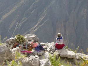
The woman in the picture ran a strategically placed shop, located about 1 hour from the top of the Colca Canyon. Even though the drinks were expensive we had no hesitation buying them on the climb back up.A long and somewhat crazy day began in Puno with an early wake up call to catch the 8.30 bus to Arequipa. Arequipa, Peru's second biggest city, lies north west of Puno, a long six hour trip, with with good views of mountains such as Misti and Chachani along the way. No sooner had we arrived and found a hotel in Arequipa than we were booked on a climb to Cerro Chachani, a 6075 metre peak - leaving in 8 hours time at midnight! So with 6 hours sleep the previous night followed by a six hour bus journey, we were clearly well prepared for a first attempt at 6000! The reason we booked the trip for that evening was that the company had a tour leaving that night and they offered us a special deal if we went with the same group. The guy in charge seemed to think all our time at altitude in Copacabana, La Paz and Puno was sufficient acclimatisation, so we signed up.
By the time we had bought supplies, packed our bags for the trek and eaten dinner it was 8pm, which meant we'd get a maximum of 3

 Sunrise on Cerro Chachani
After 1.5 hours of hiking in the dark the sun finally rose and we could see the path ahead.hours sleep. It turned out we got about 20 minutes as it was impossible to sleep knowing we'd be getting up soon at 11.15pm. Our guides showed up at midnight on the dot and off we went to the trail head. In our group were Ruth, me, a German girl called Stephanie, Pepo from Austria, 2 guides (Mario and Angel) and a driver, Vlado. Valdo, originally from Denmark, was also the owner of the agency, and had a taste for pena music (traditional Peruvian folk music) which he played loudly for the entire 3.5 hour trip to Campo Aleman, the trail head, located at 5050 metres. So no chance of getting much needed sleep then either!
I felt more sleepy than excited or nervous as we put on all our warmest clothes at the trail head and set off in the darkness. The guides walked at the front at a very slow pace via long, switchback paths. By the moonlight we could see the vague outline of a peak (which turned out to be a smaller peak in front of Chachani) and a pass to which we were headed. During the first hour I felt fine and it seemed

 Cerro Chachani
View of Cerro Chachani (left, 6075m) and Cerro Fatima (right, 5950m) from Angel Falls. neither tiredness nor the lack of oxygen was affecting me. We had a quick break at the campsite at 5350 metres, and from then on the going got very tough. The path became steeper, the air felt much thinner than before and, despite walking very slowly, almost all of us needed frequent rests to breathe properly. At 5000 metres there is about 50% less oxygen than at sea level, so it's unsurprising how difficult it was.
When we reached the top of the pass at 5600 metres, we all just threw off bags, lay down and tried to breathe. The guides made us some coca tea which helped a little but I didn't feel good. I had lost my appetite, plus I felt nauseous; two definite signs of altitude sickness. We needed crampons for the next section, the traverse of Angel Falls, a long, flattish crossing of a very steep snow field. The sun was up by now and we could see Chachani's summit; though it appeared tantalisingly close, we still had a long way to go. After crossing the Falls, I was shattered and needed a long break. We had a quick breakfast/brunch but I couldn't eat anything,

 Views of Colca Canyon
After crossing the orange bridge to Yanque, we had a fine view west across the canyon.again a bad sign. I made it another 50 metres to a final height of 5650 metres before giving up. Stephanie gave up soon after, Ruth went on to 5850, while Pepo climbed a 5950 summit, Cerro Fatima. So none of us made the top of Cerro Chachani. It was very disappointing to give up like that but it would have been even more foolish to go on given how bad I felt. The others had left me at a pass while they continued and soon after they left I was vomiting badly. There was little consolation in beating my previous climbing record by 10 metres!
Descent is usually the best cure for altitude sickness but I didn't feel good at all until we were back in the jeep at 5050 metres. We were back in Arequipa 3 hours later, and immediately I felt better and my appetite had returned. Altitude sickness is a strange affliction, you feel like hell one minute, but perfect soon after you descend. In hindsight we should have done a 2 day climb, and stopped at the campsite for a night. All 4 of us were experienced trekkers yet not one of us made

 Memorial on Chachani
I reached a spot about 50 metres above the cross, at 5650 metres, before stopping. the summit, which from base camp, was just over 1000 metres ascent.
Arequipa: The city lying behind the peak Back in Arequipa (which means in Quecha "lying behind the peak" - i.e. Volcan Misti), we finally got a chance to see the city. Arequipa contains many beautiful buildings, most notably the cathedral on the main square. If you stand on the south side of the square there is a fine view with Cerro Chachani to the left of the church and Volcan Misti to the right. The most impressive place we visited in the city was the Santa Catalina convent, a huge complex of buildings near the main square. The convent dates from the 16th century, not long after the Spanish arrived. The entrance price here was a steep 30 soles but it was well worth it, as the convent was full of history: beautiful courtyards, colourful streets, and rooms with hidden stairways and lots of nooks and crannies. A great place to photograph!
In a city with so many restaurants and bars it's easy find a cheap meal and we ate some delicious, good value food in restaurants around the city. We also spent a fun evening

 Entrance to Santa Catalina Monastery
Only a few nuns remain in Santa Catalina Monastery nowadays, though once this "city within a city" had a large population. Nowadays, there are far more visitors than nuns. playing scrabble and drinking Pisco Sour (Chachani felt a long time ago by now) in Farren's Irish Pub near the cathedral.
Colca Canyon Leaving Arequipa behind we moved on to the nearby Colca Canyon, the second highest canyon in the world, more than twice the height of Arizona's Grand Canyon. We stopped first at Chivay, a small village of 3000 people at the entrance to the canyon. There wasn't much time to trek the first day so we limited ourselves to a hike as far as some ruins above the town. They appeared to be burial plots to me, similar in a way to those we had seen at Sillustani. Chivay is as unlikely a place as anywhere to find an Irish pub, but McElroy's on the main square proved that no matter how far I travel I can never escape the comforts of home. Judging from the graffiti on the wall, it's a popular stop for gringos. They didn't have draught Guinness but we did have two delicious pisco sours during happy hour and spent some time playing pool.
Next morning bright and early we set off on a hike around the rim of the canyon. We

 Santa Catalina Monastery
The Santa Catalina Monastery in Arequipa is a fascinating place to visit. You'll need a half day to see it all. left Chivay and headed north along the road to Corporaque, the next village along the north side of the canyon, 7km from Chivay. There were fantastic views of three high volcanoes (Sabancay, Nevado Ampato and Hualca Hualca) that dot the landscape around the Colca Canyon, and we met no other trekkers all day. Occasionally we would meet a local farmer or a couple of kids on their way to school (or maybe skipping school), all of whom were all very friendly. We arrived in Corporaque and hiked up to the main square, where a crowd of locals were sitting on the steps. It felt like one of those moments when you walk into a bar, everyone goes quite and turns to look at the newcomers!
From Corporaque there was a spectacular descent down to the canyon, and the views just got better and better. We took a bright orange bridge to cross the canyon and followed the path up into Yanque, another small village. The only sight in town is the museum, but as it was Monday this was closed so instead we sat in the nice main square and had lunch facing the snow capped volcanoes in the

 Looking Rosy
Santa Catalina Monastery gardens.distance. From Yanque back to Chivay the path went via the main road. This was the least interesting part of the hike, though there were still some fantastic views over the canyon from the edge of the road. It made me a little worried about travelling this way by road the following day as in some places there was nothing between the road and a few hundred metres drop down the canyon.
After hiking 20 km we should have taken it easy in the afternoon, and that's what we did at the hot springs, though we had to hike another 3km from Chivay to get there. This is a popular spot with tour groups visiting the canyon so while we had the morning trek all to ourselves, we had to share the pools with huge groups of backpackers. The pools were lovely, not too hot, just right after a long hot hike, and we spent an hour in the outdoor pool watching sunset over Chivay and the canyon. A great end to a good day.
Cabanaconde: Gateway to the Colca Cancon We travelled along the south side of the canyon from Chivay to Cabanaconde, a spectacular route along
a road that was a little to close to the canyon edge in places, but which provided great views into the canyon. We passed through small villages before arriving at the most popular spot in the canyon - the Cruz del Condors, a popular condor watching spot. We didn't see any while the bus was stopped but a French lady who boarded the bus told us she had seen two. Most tourists stopped here and we saw them being charged the controversial 35 soles "entry fee" to the canyon. But we stayed on the bus, and ironically, having seen no condors near the condor lookout (where there was a charge), we saw a group of them at the next lookout, Mirador Tapay, where there was no charge. I had seen many condors in Chile and Argentina but never this close. Some of them swooped right down past the bus windows, so our driver kindly slowed down, giving us opportunities to take pictures.
From condor spotting we dropped down into Cabanaconde, a small village at the edge of the canyon. It's a popular spot with visitors as there are trails leading down to the floor of the canyon. Accommodation options

 Cerro Chachani from Arequipa
View of the mountain from Santa Catalina Monasteryin Cabanaconde are limited, so while we had the cheapest double room of our trip so far for 20 soles (about 6 Euros) including breakfast, it was a very damp room, with musty walls and barely room to swing cat. We had arrived at 9am, and by 10 we were ready to hike. We set off to the edge of the canyon, then followed the obvious path down. The drop from top to bottom was an incredible 1300 metres and the path was quite rough, with sharp, jagged stones and winding paths. We met some very tired looking hikers heading up, carrying large backpacks, which made me glad we'd booked a hotel in Cabanaconde and didn't have to caryy too much with us. The views became even better as we descended and we could see the outline of other trails in the distance, leading to small villages. It took 2 hours to reach the bottom of the canyon, where we found the Sangalle Oasis hotel, where we had bought a drink and ate our picnic lunch. The hotel is in a nice spot right at the bottom of the canyon, and it had a very inviting pool. It's not surprising

 Plaza de Armas, Arequipa
Plaza de Armas is the main square in Arequipa, and is dominated on its north side by the cathedral. that so many hikers stay the night here before returning to Cabanaconde. I expected the hike back up to be a killer but it turned out to be more enjoyable than the trek down, and it only took us 45 minutes more. We ran out of water before the top but to our surprise and delight a local lady was selling drinks at a strategic point before the top. There was obviously a markup as she had hauled them down there but it was still the best 2.50 soles I've spent in Peru!
Back in Cabanaconde we relaxed after our hike and had dinner with a Danish mother and daughter whom we'd met in town that evening. I was sorry to leave Cabanconde after only one night as there are some fantastic looking trails in the area. But, once again, we had no choice as we need to pick up the pace if we are to make Mexico by September. We left Cabanaconde for Arequipa bright and early, arrived there in the afternoon and booked onto an overnight bus to Cusco. Anyone who has read the Lonely Planet Peru guide has probably been scared off taking overnight buses, but

 Chivay from the cross
A short hike outisde the village of Chivay, at the edge of the Colca Canyon, takes you to a cross and a mirador overlooking the town.the company Cruz del Sur seemed very security conscious to us, and we had no hesitation booking with them. So leaving canyon country behind, we headed on to the city of Cusco, former capital of the Inca empire and our planned base for the next few weeks.
Advertisement
Tot: 0.084s; Tpl: 0.013s; cc: 8; qc: 24; dbt: 0.045s; 1; m:domysql w:travelblog (10.17.0.13); sld: 1;
; mem: 1.1mb


