Advertisement

 Cerro Salkantay
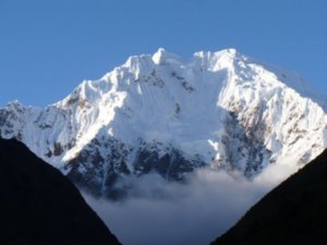
Views of Cerro Salkantay from Soraypampa. At 6271 metres, it's the second highest mountain, after Ausengate, in the Cusco region.We arrived in Cusco bright and early at 6am following an overnight bus from Arequipa. It had been difficult to sleep so it was something of a relief that there were people there waiting at the Cruz del Sur station to offer us a cheap hostel. We, along, with two other backpackers, Nick, from Canada, and Kirilee, from New Zealand (whom we'd get to know well over the next few days), set off for Hostal Apu Wasi in San Blas. Our driver took the scenic route via Plaza de Armas, which looked magical in the early morning light (for the rest of our time in Cusco I would never see the square so devoid of people). We spent the next three days getting to know this beautiful city, visiting it's museums, cafes, restaurants, and old buildings. I'll talk more about Cusco in a later blog, as this blog is primarily about hking the Salkantay trail.
Before arriving in Cusco we knew we wanted to trek to Machu Picchu but we weren't sure which trail. Most hikers aim for the Inca Trail but since 2005 this trail has been limited to 500 people

 Denilson & Son
We camped in Denilson's farm on Day 1 at Soraypampa, a village in the valley below Cerro Salkantay. per day (incuding guides and porters who outnumber tourists), and at the time of writing was booked up until September 2008. The Salkantay trail is the next most popular choice, though it's more than twice as long as and far tougher than the Inca Trail, and includes a pass of 4600 metres altitude. We shopped around the various agencies in Cusco and received quotes ranging from 180 USD to 450 USD. No guessing which one we went for! Our price included entrance to Machu Picchu, train back to Cusco, a guide, mules, 2 cooks, 12 meals, tents and sleeping mats. Given that the entrance fee to Machu Picchu is 45 USD and the cheapest train 31 USD one way, Hiking Peru's price of 180 USD was very good value indeed.
Day 1: Mollepata - Soraypampa (15km - 800m ascent) We were collected from our hostel at 4.30 am and taken to the bus station where we boarded a bus to Mollepata (2800m), access town for the Salkantay Trail. The journey took about 3 hours, and we had good views along the way, including spectacular ones of Cerro Salkantay (6271 m). Mollepata is a small place and despite the

 Anyone for Centipede?
After 3 days on the trail Arturo was getting a bit tired of the food, so tried something different. daily influx of visitors it didn't seem at all a tourist town. There were a couple of places on the square offering breakfast, so we ate here while Hubert, our guide, organized the mules. We were a group of 9: myself, Ruth, Sebastian from France, Mark from England, Trang & Tiffany from USA, Natalia & Leticia from Argentina and Arturo from Brazil. So quite a good mix of people! Before leaving, two others joined our group; Robert and Danca from Poland had originally booked the Inca Trail but their agency had messed up the dates so at the last minute they joined with us. After quickly getting to know the others in our group over breakfast, we set off at 9am.
We walked at a steady pace as there was plenty of ground to cover, but Hubert made sure we stopped frequently. Often these stops were to observe the local plants, such as cacti, muña and others which are used by the local population for both nourishment and medicinal purposes. I thought we were walking fairly fast but it wasn't long until the mules, muleteer and cook passed us out. They walk this way about once a week so

 Mollepata Main Square
Mollepata is the small village from where the Salkantay trek begins. I suppose it's not too surprising the speed they go at. One of the good things about going on an organised trek is that the mules take most of the gear! After about 3 hours hiking we had a quick stop at Cruzpata at 3300 m altitude, where the stunning Cerro Umantay (5850m) came into view. There was a shop at this spot, and despite having brought plenty of supplies, we decided to stock up some more just in case. From Cruzpata there was another 1.5 hours of walking to the lunch spot. We had ascended about 600 metres by lunchtime, though the path wasn't too steep and we all felt fine.
I wasn't too sure what to expect from the meals on the trip but lunch that day put my converns at rest, as we had a fine and filling meal of mushroom soup, lomo saltado (stir fried beef with rice - a Peruvian speciality) and coca tea. Sunset falls early in Peru so we had to cover the afternoon section along the Rio Blanco valley in 3 hours. Cerro Umantay was impressive, but it was nothing compared to Cerro Salkantay, which first came into view as we

 The start of the adventure
The group sets off from Mollepata. approached the hamlet of Soraypampa, our camping spot for the night. Despite having to wash up, clear away and load the mules after lunch, the muleteers had already set up our tents by the time we arrived in Soraypampa. The campsite was in the grounds of a local farm run by a man named Denilson. It immediately became very cold after sunset (approx 6pm) as we were at an altitude of 3800, so we all wore our warmest clothes for the rest of the evening. Dinners was served in one of Denilson's rooms, and we had a fantastic meal again. First there was hot chocolate, popcorn and crackers. Some of the group thought this was the entire meal, but not quite, as there was still soup and beef with rice to follow! Almost everyone retired to bed early as it had been a long day and it was very cold. We had a full moon that evening which lit up Umantay behind us - there were also perfect views of the night sky with thousands of stars on view.
Day 2: Soraypampa - Chaullay: Over the Salkantay Pass (23km - 800m ascent, 700m descent) It grew even colder throughout

 Shop at Cruzpata
This strategically placed shop at 3300 metres and one hour's hike from Mollepata had a good amount of business from our group.the night, and I swore revenge on that Chilean man who told me the sleeping bag was good to -10 degrees! We were woken at 5am by Hubert and Claudio (the cook), who brought us all a cup of coca tea, which I held to my face to heat me up, before reluctantly struggling out of bed. After another delicious meal, we were all set for what was supposed to be the most difficult day of the hike, both in terms of distance and altitude. Salkantay had been visible last night, but was now covered by ominous looking clouds. We faced 800 metres of ascent before the pass, though the path wasn't too bad at first. The most difficult part was a series of 7 switchbacks which took us to a false pass, before a final hike to the real pass. Some of the group had flown in from Lima only a few days before, thus hadn't had time to acclimatise properly, so it was fantastic that we made it as a group in 3.5 hours. (Hubert told us the fastest group he had did it in 1 hour from camp - leaving him behind). We were surrounded by clouds

 Evening of Day 1
After a good day's hike from Mollepata to Soraypampa we were rewarded with fantastic views of snow-covered Salktantay as we reached the campsite.by this point meaning we missed out on the (supposedly) superb views of Salkantay and its glaciers. After one or two obligatory group shots at the pass, we began our long descent along the Rio Salkantay valley.
We had brief glimpses of snow-covered Cerro Tucaray on the descent before the clouds again enveloped us and everything around us. The cooks had set up lunch inside a tent, and it was with much relief we reached the lunch area. Hubert was sure the rain would clear as in 5 years as a guide he had never had rain from the top of the pass to the bottom of the valley. But today was to be the first time! After lunch, the weather grew worse, the path was muddy and slippy and at times it felt like we were walking in a river! We left the mountain terrain behind and entered a rainforest. Everyone was soaked through at this stage, and we couldn't really stop for breaks in the heavy rain, so we had to plough on. Nevertheless, the beauty of the rainforest and the varety of the plants and flowers was impressive despite the conditions. We finally arrived at Chaullay

 Dinner in Soraypampa
Note the warm clothes everyone is wearing. Soraypampa is at 3800 altitude, and as soon as the sun set, it became very cold. campsite at 5pm in the evening. We had hiked 23 km in atrocious weather, but everyone was still in fairly good spirits.
This campsite was in a beautiful location at the foot of the Salkantay Valley, though overall I think it was my least favourite of the campsites during the trek. There was one toilet for the family, 11 hikers and support team, but unfortunately the toilet didn't flush - I'll say no more about that!! We had dropped to 2800 metres but it was still a very cold evening, meaning we'd have little chance to dry wet clothes. Still, we had a fantastic dinner and another good night's sleep. Robert and Danka were leaving us the following morning as they were going to join their original group at Santa Teresa. They were a great couple and had kept us all entertained with their stories over the first two days.
Day 3: Chaullay - La Playa (15km - 600m descent descent) Thankfully the bad weather had departed and we awoke at 5.30am to cloudless skies, though it was still cold at this altitude. After a cup of hot coca and another filling breakfast we set off from

 Clouds in Salkantay Valley
Early on Day 2, the clouds and fog were a sign of worse weather to come.Chaullay. The first part of the hike was a descent to Colpabamba, the meeting point of four valleys. We followed one of these valleys - Valle Santa Teresa - for the entire day, a hike which took us through beautiful cloud forest, along the left bank of Rio Santa Teresa, where we could see a whole host of flowers and fruits. In one section I remember seeing coffee beans, bananas, passion fruit and corn growing. We stopped at a small farm for a short break, where I bought a whole bag of passion fruit for 1 sol. These were delicious and it was just as well I bought a bag as we had a long way to go until lunch.
It took a good six hours to reach our lunchspot in the village of La Playa. This was also where we said goodbye to our muleman, Eusebio. He would be returning back to Mollepata alone, while we continued by bus to Santa Teresa. I didn't expect that we'd be taking the bus for any part of the trail, but I think we were all relieved to have this option. It also gave us the opportunity to visit the Hot

 Eusebio leads the mules
Our mule man Eusebio leads his mules up the switchbacks before the Salkantay PassSprings in Santa Teresa. After 3 days without a shower, a visit to this springs was pure bliss and also something of a necessity! We had a lovely meal in the campsite that evening, washed down with a few beers (much deserved after all the hard hiking), and we rounded the evening off with a game of UNO.
Day 4: Santa Teresa - Aguas Calientes (15km - 160m ascent) The mornings up to now had been very cold but at Santa Teresa we were at a much lower altitude, so it was a nice change to wake up unshivering. We left Santa Teresa and hiked down to the river. On the way we passed what looked like old ruins, but which on closer inspection turned out to be much more recent. Hubert explained to us that these were the remains of old Santa Teresa. In 1998, the village was destroyed in a flood caused by a landslide in the nearby Aoabamba Valley. No one in Santa Teresa was killed but the village was destroyed and since then "new" Santa Teresa has been built high above the river. This flooding also destroyed the rail link to Quillabamba, meaning the train
now only goes a short distance beyond Aguas Calientes.
To cross the Rio Santa Teresa we went via an oruyo (a cable and sling type bridge), which looked scary but turned out to be great fun! We were now hiking alongside the mighty Urubamba river, and again the scenery was fantastic, with a huge variety of frutis an flowers on view. As we approached the ydroelectric plant we had our first view of Machu Picchu on a ridge high above the Urubamba. We were within striking distance! Lunch was at the train station near the Hydroelectric plant, before the final section of the trek, along the railroad tracks to Aguas Calientes.
In 4 days on the trail, other than local people, we had met very few hikers, so to return to a place Aguas Calientes was a bit disconcerting. This town was once a small farming village below Machu Picchu, now it's a complete tourist trap, with overpriced hotels, restaurants and endless souvenir shops. Nevertheless, we had finished our hike, and we could relax in a nice, warm bed and enjoy a hot shower for the first time in days.
After 68 km, 4 tough days, rain,

 Ruth at 4600
Looking happy at the Salkantay Passsun, snow, hailstones, cold mornings, we had finally made it!! Salkantay may not be as well known as the Inca Trail, and it doesn't offer the chance to see Inca ruins along the hike nor the privilige of entering Machu Picchu directly at the end of the hike; but it is a long, challenging hike, passing through high mountain passes, rainforest and beautiful valleys, and there are far fewer trekkers on the trail and more ìmportantly there is plenty of opportunity to interact with the local people. Our group also got along extremely well and by the end we were all close friends! Eleven is a large number of people for one group but I couldn't have asked to hike with a nicer bunch of people.
The fun (nor the early mornings) didn't end there as we had a full day at Machu Picchu the following day. But that's another story....
Advertisement
Tot: 0.397s; Tpl: 0.019s; cc: 27; qc: 116; dbt: 0.2573s; 1; m:domysql w:travelblog (10.17.0.13); sld: 1;
; mem: 1.5mb


Gracia
non-member comment
TREK SALKANTAY
I just want to know how ws this trek for you and if it s better than the one tht is called CAMINOS DEL INCA....because everything was booked for this trek, I read some commnts about this SALKANTAY trek and it looks much better.....waht do you think?