Advertisement
Published: October 24th 2008

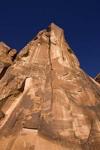
 petroglyph walls
I did include two images of the petroglyph walls but neither of these focus in on the petroglyphs. I did not saturate this image to get the deep blue sky - it pretty well reflects what I saw.What an absolutely fantastic day! I drove along the Colorado River 17 miles south of The Arches National Park entrance in the morning. That road is called Potash Road for the potash and salt mine at the end of it. There are Indian petroglyphs on some of the canyon walls (I didn’t work on any of those images to see if I captured them in the morning light), several arches and fabulous views along the river.
While I was photographing at a primitive campground about 5 miles along the drive I struck up a conversation with a couple. They were staying in their RV (dry camping) there and we had a really nice talk. I learned from them that before the potash and salt were mined, uranium was discovered in the area. The train tracks that run alongside the road was used to transport it out. It’s now used to transport salt and potash.
I spent all morning on that section of the Colorado River. I stopped by the Arches NP visitor center and had my picnic lunch and started north along the Colorado River. I drove about 20 miles north and the views were even MORE SPECTACULAR in

 perspective
This is the base of the same wall seen in the previous image. I spoke briefly with this couple and this man's wife made the comment about having him in the image to show perspective. I thought it was a GREAT idea so I snapped a shot as well. Even with my wide angle lens, I couldn't get the top (nor the bottom in the earlier image). But hopefully this gives you a good idea of how tall these walls are.that direction. I’m sure I didn’t adequately capture the essence of the magnificent views but it sure wasn’t for lack of trying! Around every bend and turn was another breath taking view.
I learned from Cousin Jeff and “Cousin” Brenda that a young man from NC is working out here. They are good friends with his parents. The resort where he works is on the northern section of the Colorado River so I stopped in and visited with him for a few minutes this afternoon. He was totally shocked when I went in, asked for him, and told him how I knew of him. We both enjoyed our brief visit.
Then I made a loop on Castle Valley Road and the La Sal Mountain Loop Road back into Moab. In reviewing my Photo Traveler’s Guide to Southeast Utah just now one of the formations I saw and photographed today just clicked (pun intended). It was Castle Rock and it looks like a huge castle. I didn’t edit any of those images for inclusion in this entry - perhaps another day. Castle Rock was just before Priest and Nuns formations.
I got a late start this morning -

 Jug Handle Arch wide view
Here's a wide angle view of Jug Handle Arch. You can see the arch on the right side of the wall. This is right along the road, but even with my guidebook, I missed it initially. I drove about 1/2 mile up a dirt and rock road (which had some awesome views, too) and then realized the arch was back next to the road. Next trip I'll have to tow Ike out here so I can do some off roading. Jeeps are EVERYWHERE. departed around 8:30 - and didn’t return to the RV until 6:30. I plan to get an earlier start tomorrow and head up to Dead Horse Point State Park and the northern portion of Canyonlands National Park.
Hope you enjoy the images from the day. Thanks for checking in with us.
BTW the weather is perfect, too. It was 32 this morning but pleasant and about 60 in the afternoon. Tonight is supposed to be around 35 with upper 60s on Friday and warmer over the weekend.
Advertisement
Tot: 0.147s; Tpl: 0.012s; cc: 12; qc: 75; dbt: 0.0912s; 1; m:domysql w:travelblog (10.17.0.13); sld: 1;
; mem: 1.2mb

 petroglyph walls
 perspective
 Jug Handle Arch wide view


