Advertisement

 Mount Rainier
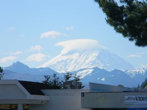
from the road through Enumclaw, WAThis morning was sunny and mostly clear. The standing water from yesterday evening’s hard rain was mostly gone. We drove east to Hwy 410, getting an occasional glimpse of Mt. Rainier. Hwy 410 was beautiful, with dark forests, the green waters of the White River visible through the trees. However it was very bumpy. It made my adventure road feel like a newly paved super highway. Well, not quite. At Cayuse Pass, elevation 4694’, there was plenty of snow along the sides of the road. The road had steadily climbed to the pass and then, of course, we went down. It wasn’t too bad, but Kerry does hate those steep downhills. After Cayuse, the road south became hwy 123 for a while before joining US Hwy 12. While in the Mt. Rainier National Park, the scenery was very pretty, with snowy mountains and green forests, but we never saw The Mountain, Mt. Rainier. There were almost no pull outs for scenic views and the visitor center at the SE corner of the park had very little parking and the rv parking was at least ¼ mile away. In order to see the mountain we would have had to take twisty mountain

 White River
Hwy 410 pretty much runs along this riverroads up several miles, but I think those roads were closed until July anyway. It was altogether disappointing. I feel lucky that I was able to snap a few pictures from the car of Mt. Rainier before we got to the park.
After leaving the park we drove west on Hwy 12, where there was a big street fair or something in the town of Packwood. There were booths set up along the road through town and the traffic was pretty backed up. The people did look like they were enjoying themselves, which is what it is all about anyway.
We got back on I-5 and drove south to the Mount St. Helens visitor center. The atlas calls it Mt. St. Helens
National Volcanic Monument, but the visitor center said it is a state park. Whatever. We could not see the mountain from the visitor center, and didn’t have time to drive 90+ miles round trip to see it. So another letdown.
South to Vancouver, we did get to see Fort Vancouver. It is a beautifully maintained park, the site of a fort which was instrumental to the fur trade back in the 1800’s.
From there

 Entrance
Mt. Rainier National Parkwe crossed the mighty Columbia River again into Portland, Oregon. We are stopped for the night in a nice campground in Troutdale, where we were treated to another big thunderstorm after supper.
Advertisement
Tot: 0.072s; Tpl: 0.009s; cc: 11; qc: 30; dbt: 0.035s; 1; m:domysql w:travelblog (10.17.0.13); sld: 1;
; mem: 1mb

 Mount Rainier
 White River
 Entrance


Barbara
non-member comment
SNOW?? Send some here, it going to be 98 Monday!