Advertisement
Published: August 8th 2023

 PXL_20230807_062819131
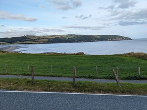
The view from the patio of our hotel looking south across Teifi River inlet Monday 7 August 2023. Day 20 on the Pembrokeshire Coastal Path from Ceibwr Beach to Poppit Sands and St Dogmaels. This is our final day completing the 180 miles (300 kilometers) walk from Amroth.
Alltrails app. 3 hours 45 minutes walking. 7.58 miles. 1211 feet elevation gain.
Garmin forerunner 25. 4 hours. 7.7 miles. 1253 feet elevation gain.
Home James is the name of the taxi company that has been our shuttle at the end. They picked us up yesterday at Ceibwr Beach and returned us there this morning. The two vans were different each time and very new and roomie. A lady was the driver yesterday afternoon and an older man today.
Home James was in front of the Gwbert Hotel ready to transport us before 9 am.
Today the trail reaches the highest point of around 600 feet. So out of the cab and up the hill we walked. We are now far enough along this part of the coast that we can look back and see Stumblehead light flashing in the far distance. The weather was only partly cloudy and no rain. Visibility was good and we could just make our the north end

 PXL_20230807_062829465
The Gwbert Hotel and Flat Rock Bistroof Cardigan Bay, sixty miles away.
Again we were walking along the cliff edges going up the hills, going down the slopes and then along the cliff tops near the farm fields.
About 2 miles along we met a lone young lady going the opposite direction and just starting her Pembrokeshire Coastal Path walk.
It is now clear to me that Amroth where we started is the border to the next county, Carmarthen, along the coast. So the path only goes the entire coastal shoreline of county Pembrokeshire in Wales. The crow flight distance between Amroth and Cardigan is less than 30 miles. The Wales Coastal part part of the path around all of Great Britain is over 800 miles.
As we rounded the corner of the bay we could see the Cliff House resort and Gwbert Hotel directly across the water of the inlet feed by the river Teifi (pronounced teever).
We had sandwiches at Poppit Sands, very popular and busy beach, and took photos at the signs for the start/finish of the path there. Then we walked a mile and a half farther to the Ferry Inn. The book and alltrails navigation show this

 PXL_20230807_072043993
View looking north from our roompoint as the end/beginning. We took more pictures there as well.
A third Home James taxi driver in a small SUV picked us up at 1330 as agreed and brought us back to the hotel
Back at our hotel by 2 pm we all had a drinks and I played Frank Sinatra song "My Way". We did it our way!
We were a very congenial group and have different perspectives about this long walk. It was a nice way to spend a month where the temperature varies from 52 to 72 degrees for the entire duration. Back home every day was over 100 degrees. The ocean views are all refreshing although sometimes perilous.
Til next time thanks for reading.
Advertisement
Tot: 0.35s; Tpl: 0.013s; cc: 9; qc: 53; dbt: 0.1233s; 1; m:domysql w:travelblog (10.17.0.13); sld: 1;
; mem: 1.2mb

 PXL_20230807_062819131
 PXL_20230807_062829465
 PXL_20230807_072043993


