Advertisement
Published: August 6th 2023

 IMG-20230806-WA0000
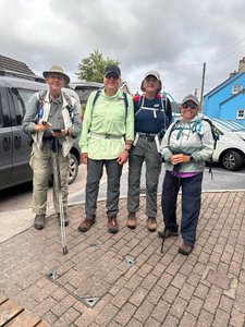
No taxi so we walk down the street together Sunday 6 August 2023. Day 19 on Pembrokeshire Coastal Path - Newport in Pembrokeshire to Ceibwr beach.
Alltrails app. 4 hours 24 minutes walking. 8.05 miles. 1275 feet elevation gain.
Garmin forerunner 25. 4 hours 26 minutes walking. 8.1 miles. 1348 feet elevation gain.
Saturday was a planned rest day and it rained. Rested my knees.
At 0910 we left our Golden Lion Hotel to walk about 0.3 miles to the start of today's walk. We joined the coastal path at the bridge where the stream meets the bay. The tide was out and several types of birds were enjoying the mud flats. We could see that the previous high tide had deposited sea debris on the path.
Before reaching the start we passed the neolithic burial site estimated to be 5000 years old. Archeology shows this site was used for about 450 years starting in 3000 BC.
Our books said this section was one of the most rigorous with about 1500 feet of elevation gain and reaching 500 feet above sea level. But much of it was a more gentle continuous up not the very steep but shorter ups from prior days.
While

 PXL_20230805_103348112
Carreg Coetan Burial Chamber. we met several folks walking the opposite direction only a few were starting to do the walk from north to south. These folks are just starting as we are one day away from ending.
Cardigan Bay begins as we come into St Dogmaels. It continues for 60 miles to the north and is the largest bay in Wales. In comparison Milford Haven is 22 miles deep.
Besides Pembrokeshire there are 28 other counties in Wales. At Cardigan we leave Pembrokeshire and enter Ceredigion.
Advertisement
Tot: 0.282s; Tpl: 0.012s; cc: 12; qc: 53; dbt: 0.0786s; 1; m:domysql w:travelblog (10.17.0.13); sld: 1;
; mem: 1.2mb

 IMG-20230806-WA0000
 PXL_20230805_103348112


