Advertisement

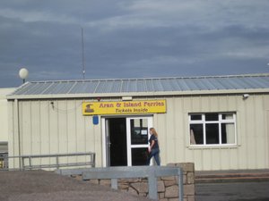
 Ferry ticket office
traded our voucher for real tickets and bought bus tickets for the evening.There are three islands off the coast, the Aran Isles. For a day trip, we could only figure out going to Inishmore. If you stayed the night, you could then go on to another one or two the next day. We had booked the ferry before leaving home but didn't get it together to figure out the bus out to the dock in Rosaveel so we took a taxi out; the driver (playing Johnny Cash music most of the way) told us we could buy a return bus ticket at the ferry office and save money and time. We had to go in there and exchange our vouchers for tickets so we bought the bus tickets at the same time. Very friendly and efficient. I think the ride was about 50 minutes but, honestly, we fell asleep within minutes and napped the entire trip over to the island.
John and Bobby Joe (his horse) met us at the dock, just as he said he would. John grew up on the island, worked away as a fisherman with big companies for years, and has retired to the island. His children live in England and Galway; he and his wife built a
new house on the site of the old one, he rents space in a barn for the horses from his cousin who's living in America. Obviously very proud of the island, and pleased to be doing this as a retirement living. He has three horses so each only works every three days, at the most. He outlined the route we would take, telling us the island is 12 square miles, has a populace of 800, has seven churches built in the 6th century, and is Gaeltacht (Irish-speaking), has three schools and a technical school.
We started off in a windy mist/rain, about the same time as several mini vans (there are 39 on the island), a couple other traps, and numerous people on bikes they'd brought or rented (including electric ones). There were two routes so the traffic diverged a bit. First stop was to see the seals along the beach edge. They live there year-round and, later, when heading back to the ferry, we could hear some of them barking. The first part of the island had lots of stone walls, the seal beach, a couple of church ruins, an abandoned seaweed production plant, and the recycling facility.
All non-recyclables have to be shipped to the mainland to be disposed of just as all products have to be imported, from food to cinderblock.
There are walls all over the place; they are not necessarily there to delineate property (which they do) but to do something with the rocks.
Dun Aonghusa, one of western Europe's most magnificent stone forts, managed by the OPW, was the last of the part of the island that was not really inhabited. Over 3000 years old, they've found metalworking, houses, and burials; it was REfortified in 700-800 AD. No one is sure who the "Angus" was for whom it's named; there are a couple of candidates. I paid the 4Euros and hiked up the 1 km 'trail'. The beginning was gravel but soon gave way to just plain rocky path, lined by more walls. There is no fence or barrier at the edge of the cliff. It's an 87 meter drop. The fort faces the Atlantic Ocean and has three massive drystone defense walls in the shape of a semi-circle with the cliff as the outer edge. Beyond is a chevaux-de-frise, a dense band of jagged, upright stones, thousands of them. A
very effective way to impede intruders, the chevaux surrounds the entire fort, from cliff to cliff. I wandered around (see pics) and made it within a couple feet of the edge at a point where I could sit and lean forward a bit but it felt very strange very quickly. And, yes, as is often the case, the walk down was almost worse than up. Thank heavens for new knees!! See https://heritageireland.ie/dun-aonghasa for better pics on a clearer day.
When I came down and before we set off again, John walked us up a path to a beautiful ruined church. Built in the 10th to 12th centuries, you can see the difference in the stones and stone work between the older and 'newer' parts. Outside and a bit away is a carved stone with the Christian cross on one side and the Celtic cross on the other. That was one of the seven ruined churches on the island; there is one functioning Catholic church.
There are 10 'villages' on the island and each has a name sign in the rock wall as you pass it. John paused at each, pointed out his house when we passed it, and
told us who was now living in London, America, Australia, etc. They don't sell the property--might want to return. He pointed out the highest point on the island which used to be manned, keeping an eye out for intruders.
There are many older traditional cottages, now abandoned, scattered around the island. Stone with three windows, a door, and a chimney. Now, mostly covered in vines.
Returning us to the little area near the ferry, we ate a great late lunch at The Bar then wandered the shops until time to get on the ferry. Again, we napped through the trip. The bus was awaiting us and we rode back to Galway in pouring rain. While it was overcast and sprinkling some on Inishmore, it seems to have poured on the mainland. We walked back to our B&B; a hot shower and sleep was all I required after that climb!
Advertisement
Tot: 0.045s; Tpl: 0.012s; cc: 15; qc: 28; dbt: 0.0179s; 1; m:domysql w:travelblog (10.17.0.13); sld: 1;
; mem: 1.1mb


