Advertisement

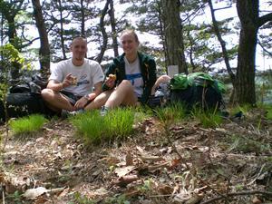
 Still smiling
Ham and cheese sandwiches for lunch on top of our first peak of the day.
Darrell and Cathy We woke up in the middle of our beachside forest to the sound of fifty year-old women exercising next to us. It seems the ajummas here are far to tough! Within minutes we had packed our backpacks, found the public bathrooms to brush our teeth and caught a bus inland towards Seoraksan, Korea's biggest National Park. We got off the bus along the side of the road and walked the few minutes to the entrance to the hiking trails.
As we reached the north entrance to the mountain trails, the friendly park ranger came out of his little booth to give us a fantastic trail map, and casually inform us that the trails are all closed. Apparently we had arrived on exactly the last day of the fire hazard (dry) season. Believe it or not, despite our camping through the rain last night, the mountain is too much of a fire hazard to be accessible. Tomorrow of course will be safe. As we started to plead with him, he went on to tell us that the area we were planning to hike was also closed for the year for rehabilitation. Seriously!?!
Now stranded along the highway in the

 Our trail
Follow me, I'll show you the way!middle of nowhere, we decided to do what any good students would do - we followed the road around the corner and turned up the next ravine into the mountains. Our plan from the start had been to take 2 days to hike accross the park from north to south over 2 days. We reasoned that by tomorrow it would be the official hiking season and we'd be hiking in the open part of the park.
Once in the park we found that our choice to go off-trail meant that we were hiking up and down the steep, forested sides of the mountains. Often scrambling and sliding on slopes around 45deg. We tried to join the trails further in, but noticed that workers were busy rebuilding the trails, so instead headed straight up the ridge of the line of dominant peaks that runs across the park.
We knew that the highest peak, Ansan, stood at least 200m above any of the others, at 1431m. We could also tell from our map that it was the last peak in the string we were hiking. What we didn't know, was which peak we were on at any given moment (the

 Down there?!?
Contour paths? Who needs them!benefit of being off the trail), we could only see the steep side of the peak directly infront of us. All we knew was that each time we scrambled to the top of a peak and could see that the next peak (or the one behind
that was still above us, we were going to have to follow the mountain ridge down between the two peaks and up the other side.
Each scramble found us having to urge each other on over the frustration of sliding backwards, being scratched and wacked by plants and stumbling in the thick leaves. As we topped each peak, we would have a few moments of awe at the 360 degree views and the lush valleys that dropped steeply off to both sides. Then we would be jolted back to reality by the next peak which each time was clearly just a little bit higher than the one we were standing on.
About 2/3 of the way into the hike we realised that we had not carried enough water. Our original plan had been a gentle waly up along side the waterfalls and pools up the valley trail. By avoiding the trail we

 And back up here?!?
What comes down must go uphad also inadvertently managed to avoid all water to the extent that we could barely even hear the cool mountain rivers downing the valleys either side of us.
We continued to sweat our way up and over peak after peak with the thought of tinned peaches and the water we were saving for supper driving us on. After climbing so many peaks that we peaks that we were so sure were each Ansan, we finally summited a peak that stood apart from all the others. A few meters before the top we passed a lovely grassy area in the shelter of some trees, and unanimously decided that would be our campsite. We dropped our packs and used the last of our energy to push our bodies up the last few boulders to the peak. The view that greeted us was truly glorious, exept for one tiny angle... On the other side of a deep valley, it the distance stood the one peak which clearly towered over the rest of the park. We were not on top of Ansan. Not even close to it!
With a peace that sometimes only comes with accepting defeat we returned to our packs

 Makes you want to take off
Off trail, on top of an unnamed peak, 5 hours hike from anything on our map. That's freedom!to pitch our tent. No, we were not where we had planned to be, but we were in a fantastically beautiful spot, and had already given ourselves over to the idea of supper and a good nights sleep.
The noodles and soup did not disappoint, and the tinned peaches were almost delicous enough to make us cry. With that out of the way we crawled, smelly and dirty, but with the little pleasures of clean socks and underwear, into our sleeping bags. Now all that we needed was for the lights to go out. It was only 6pm.
Advertisement
Tot: 0.303s; Tpl: 0.013s; cc: 36; qc: 162; dbt: 0.1855s; 1; m:domysql w:travelblog (10.17.0.13); sld: 1;
; mem: 1.5mb


David
non-member comment
Dry Season!!!
No water fire danger forest and darrell making the fire..... Please come back alive :P