Advertisement
Published: March 20th 2017

 IMG_0106
Down StreamAuburn RV Park, Auburn, AL
We hitched up, said goodbye to Lake Tobesofkey, and programmed Auburn, Alabama into the car's GPS system. It offered us three different routes, one of which took us all the way back up to Atlanta and then back down, using interstate highways the whole trip. Not wanting to revisit that mess, we opted for a leisurely drive over Georgia state and county roads to Columbus and then US 80 on into Auburn.
We stopped for lunch at a brew pub in downtown Columbus located in one of those restored downtown areas. We were able to find parking on a side street that wasn't busy. Food was tasty but not overwhelming. We both had chicken dishes, Joan's came with shrimp in a Cajun style sauce, mine had a mushroom gravy and mashed potatoes. I'm enjoying the y'alls and southern accents of the waitresses.
We are staying at the Auburn RV Park, a commercial place just across the street from a state park. We normally do not like staying at commercial places - the rates are too high and we really have no use for all the 'entertainment' value these places try to add. But

 IMG_0108
Joan Journaling Creeksidewhen Joan had inquired about the need for reservations at the state park, she was told that we didn't need them. But then, two weeks before we started the trip, she called again to confirm and they reported that they were all booked up. So, assuming some big event was happening, she booked us here to make sure we had a spot to stay.
The ride in was relatively easy and interesting. Driving county roads, we got to see rural Georgia as well as you can without stopping. As in Tennessee, you can't drive more than a few miles without seeing another residence of some kind. And they range from dilapidated shacks to 'plantation' size mansions with acres of groomed front yards and immaculately kept fences.
The most interesting part of the drive, though, was the natural scenery. This trip goes through four or five distinct ecological zones, and we have now seen three of them. Russell Cave, Chattanooga, and Marion County Park were all in the Appalachian Highlands. As the name suggests, this is the 'mountainous' part of the trip, although to those of us who live in the Rockies, 'mountainous' is rather hopeful term. But there

 IMG_0109
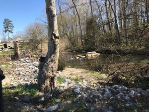
Looking Upstreamare definitely lots of beautiful hills and valleys, limestone rock beds, and scattered old igneous rocks from when the Appalachians were formed hundreds of millions of years ago. (These mountains formed when North America slammed into Europe as part of the formation of Laurasia, a massive continent that predates the Atlantic Ocean.).
The Highlands are covered in rich deciduous forests full of hardwood trees of nearly every description. They were, and are, a rich source of nuts which formed a significant part of the Woodland Indian diet. We started our Southern Charms tour there and will return to it at the end of the trip.
Just to the south and east of the highlands is the Piedmont. This is a band of mostly sedimentary rocks that are, really, the products of wind and, especially, water erosion of those Appalachian mountains. In Alabama and Georgia, they refer to this band as the Black Belt, because the soil is so rich. This area is where the most productive agriculture is found and where most of the cities are located. Atlanta and Macon are on the Piedmont, as is Columbia, SC, and the Raleigh-Durham area in NC. Vegetation continues with dense

 IMG_0112
How to Spend a Lazy Dayforests of deciduous and pine trees.
Macon, and I suspect Auburn as well, are located at the border of the Piedmont and the Atlantic Coastal Plain, the third geological zone. The coastal plain should really be considered the flood plain for the Atlantic Ocean. When the earth was a lot warmer, and the oceans fuller, they extended pretty much right up to the Piedmont. As a result, this area is pretty much just sand and is not very good for agriculture of any kind. Pine forests increase in this area, mixed with cypress and other really hardy trees. In fact, aside from the trees being taller and denser, they look a lot like the forests at home, where we don't have very good soil either.
We learned something else from an Ocmulgee ranger the other day. Along the border of the Piedmont and the Coastal Plain the land falls off some - maybe just a few feet elevation decrease, but enough to produce water falls on the rivers and creeks. If you draw a line connecting these waterfalls in all the rivers, you create what they call The Fall Line. And it is the Fall Line that serves

 IMG_0107
Auburn RV Campsiteas the border between the two ecological zones. It is also where rich finds of archeological artifacts have been found and where a lot of today's cities are located. The Indians located there because the border between two eco-zones is always a very rich source of food and materials - you can take advantage of two ecosystems from one location.
At anyrate, our 130 mile drive yesterday took us down into the Atlantic Coastal Plain and back up onto the Piedmont. We got to where we could easily tell the zones by the nature of the forests. It was a fun and easy trip.
But we are tired again and in need of fresh laundry. So today will be a down day. (17.1.12
Advertisement
Tot: 0.195s; Tpl: 0.011s; cc: 12; qc: 50; dbt: 0.0889s; 1; m:domysql w:travelblog (10.17.0.13); sld: 1;
; mem: 1.1mb


Mickey
non-member comment
AUBURN
Evelyn's son-in-law (my nephew-in-law) graduated from Auburn. It's definitely a SOUTHERN university with all the attending baggage...in my humble liberal opinion.