Advertisement
Published: September 27th 2016

 Trail to Hidden Lake
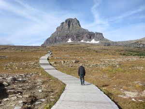
It begins as a boardwalk...so cool!After breakfast and packing (we had to change cabins today..) we drove back to Logan Pass, in the sunshine this time! The morning started out quite cold (38 degrees at the coldest point), so we set out wearing down vests, jackets, and gloves. By the afternoon, I was in a hiking skirt and tank top!
The hike to Hidden Lake starts on a boardwalk at over 6000 feet. The boardwalk uses steps to climb steeply and then turns into a trail and climbs up to 7000 feet in the first 1.3 miles! It was hard going at first... The trail is very popular, and there were quite a few people until we reached the overlook, where most turned around. Just before the overlook, a mountain goat joined the hikers, and followed us along. We tried to stay away from him since they can be dangerous, but he was intent on staying near us and the trail. When we finally decided to get past him, he came about 3 feet from a woman taking a photo!
The trail followed the base of the mountains, which are composed of uplifted layers of sedimentary rock:
Across northwestern Montana, the southern portion 
 Wish I had my paddle board...
A quiet MacDonald Lake tonightof Alberta, Canada, and the panhandle of Idaho exists a series of
sedimentary rocks known as the Belt Supergroup. Beautifully exposed in the
Rocky Mountains that cut through
Glacier National Park, where they create spectacularly scenic outcrops, such as those found along Going-to-the-Sun Road.
The Belt rocks are enormous—about 15 to 20 kilometers in thickness. They also are extremely old, with their deposition having taken place in the interval from 1.47 billion to 1.4 billion years ago, during the Mesoproterozoic era. The Belt rocks consist of horizontal sediment layers that contain minerals such as carbonate, argillite, crystalline limestone, and quartzite. These layers were stacked one on top of the other within a sprawling and topographically featureless basin that covered a portion of modern-day Alberta, as well as western Montana and eastern Washington. Over the course of several million years, water repeatedly filled and retreated from the basin, producing features such as mud cracks and ripple marks. Many unusual geologic features of the Belt Supergroup are betrayed in the impressive outcrops and formations found in Glacier. The Grinnell Formation, which weaves through the mountains and is prominent in the Many Glacier area, provides a stunning example of the sedimentary and deformation processes that were 
 Bighorn Sheep
Spotted this beautiful animal in the first quarter mile!at work during the Mesoproterozoic. A striking deformation seen in its layers of white quartzite and red argillite are folds of rock that curl upward, generally bending toward a
faultplane. Known as a drag fold, this powerful contortion of rock conveys a sense of force beyond human imagination.
Also along the Grinnell Formation lie symmetric wave-formed undulations, signs of an ancient sea, recorded in ripple marks. To see traces of an aquatic past in sedimentary rocks 6,000 feet above sea level is a bit surreal. But ripple marks can be found scattered throughout Glacier, and at various elevations. Their presence suggests that in the shallow waters of the Belt sea (an ancient body of water thought to have occupied part of the basin), or perhaps even in another body of water there at another time in the Mesoproterozic, rhythmic wave actions were at work over a sandy surface. Wave oscillations in shallow water produced small, but distinct peaks and troughs in the seabed, the impressions of which, as water disappeared, were preserved. We saw many rocks imprinted with waves as we hiked. The rocks are deep red, green, and yellow, making for striking contrasts along the trail.
We decided not to hike all the way down to the lake, since the last mile was steep and there were bears near the lake. The views from above the lake were some of the most breathtaking I've seen, and Bill and I agree that this was one of the best hikes we've ever done!
We hiked back to car and ate our lunch before heading out on the Highline Trail, across the road. This trail, while following the path of the highway, is cut into the steep slopes above it! While I'm not completely phobic about heights, I don't like them, so this trail was a bit of a challenge... The trail starts out as a narrow cut into the cliff face, with a sheer drop of several hundred feet on one side. There is a steel cable strung through garden hose to hold on to. I just kept focused on the rock wall and resisted looking down. After about .3 mile, the trail widens and crosses meadows and small stands of evergreens. Bill decided to go back after about a mile, but I continued on for another mile alone, clapping every few minutes to alert bears, so
they are not startled... Never saw one...
On the drive back we stopped for one last visit to the beautiful MacDonald River, and spent some time sitting in the late afternoon on the red rocks above the water.
Tomorrow we start the trip home, crossing Lolo Pass into Idaho.
Advertisement
Tot: 0.644s; Tpl: 0.016s; cc: 36; qc: 114; dbt: 0.2041s; 1; m:domysql w:travelblog (10.17.0.13); sld: 1;
; mem: 1.3mb


Carol McClain
non-member comment
Glacier National Park
Really enjoyed this return-by-proxy to Glacier. Thanks for taking us along and sharing the beauty. Safe trip home! Carol