Advertisement
Published: April 20th 2015

 Taking a Break
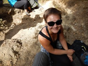
A much needed break on the first uphill.For some reason, we thought doing a 3 day hike from Xela to Lago Atitlan sounded like a great idea. The hike turned out to be amazing but that didn't stop us from wondering what the heck we were doing the night before it started. We went with a company called Quetzaltrekkers which is a non-profit organization. The guides are all volunteers and the money goes straight to providing basic needs and education for the street kids of Xela.
We started our first day having a big breakfast prepared at the the QT office. Since we had slept in the 'hotel' that shares a door to the street we just had to wake up, take our gear downstairs, and eat. Our group was lead by guides, Matt, Joshi, and Ben and we left QT at 0730hrs and had an unexciting walk through Xela to catch the Camioneta (converted School Bus; more commonly known as 'Chicken Buses' by Anglophiles) to Cantel. From there we'd warmed up and the sun started to shine so everyone had to shed layers and lather up with sun lotion. We were told the first hour and a half were the hardest of the whole trek. It's

 The Temescal
This was our shower for the night. It felt good to be sort of clean after a full day of hiking.impressive how... flexible... the truth can be when a guide is trying to help you up a hill. We had a couple stops before we reached the top which spilled out onto, what they called, Alaska. Maybe because it was a relatively open expanse.
Around noon we took a break where our first glimpse of Lago Atitlán was obscured by clouds. 😞 An hour after that we stopped for lunch, everyone encouraging each other to 'Eat more Hummus/Beans/Potato Salad/Guacamole'; whatever they happened to be carrying.
Shortly before we stopped for the night in Santa Catarina came 'encouraging lie' #2. Crossing a small creek approaching town there was more up hill but only 5 minutes... or 20; just the truth bent enough to get you up that last hill. That night we had pasta for dinner and got clean in the temescal.
Turns out the temescal is a traditional Mayan sweat hut, about waist high in this case, that we crawled into sat on a slightly raised bench and scooped hot and cold water from buckets into a third and used that to wash. Not the best clean for those of us without practice, but it was more

 The So Called "Cornfield of Death"
In my opinion, not as deadly as Record Hill.washing up than we'd expected to be able to do. After dinner many of us went to watch a traditional Mayan music and dance performance. It was interesting and the music mesmerizing.
At the end of the performance we even got to try a little dancing ourselves. We slept on floor mattresses in a guest house that night; with 21 of us we filled the place up. Sunday morning was sort of early, waking at 0600hrs. We went to a comedor (basic, cheap food establishment; doesn't typically have a menu, they tell you what they have that day) for a set breakfast of beans, eggs, rice, and tortillas. Many people would have preferred some fruit or bread, and lo-and-behold, breakfast desert of a banana and pancake with syrup arrived. It was a great breakfast and filled us up with much needed energy for the day.
We walked along a road (loosely used term) from town until our first short break at a bridge around 0930hrs. This is where we were informed that we'd reached the bottom of Record Hill; one that those most ambitious try to ascend as quickly as possible. It had a rather steep incline and

 We Made It!
The view on our last morning as the sun rose over San Pedro.they said, 'Mere mortals tend to make it up in 20 minutes.' The fastest anyone in our group made it was between 12 & 13 minutes ( we made it around 27). Ashley started to feel very unwell and even the stop in a small town for ice cream didn't help. At 1300hrs we stopped for lunch and Ashley ate little but took an Advil and a little while later she was feeling much better. We started crossing a creek (7 times) for which we had water shoes; it felt great to soak our feet after all the walking. After changing back out of our water shoes the guides took our order for licuados (fruit drinks, tend to be with water or milk or yogurt and loaded with sugar) for when we arrived a la casa de Don Pedro in Santa Clara. First we had to prove ourselves one more time by scaling the 'Cornfield of Death' (such inspiring nicknames). It wasn't so bad really but it sure sounds daunting. That night we stayed at Don Pedro's house and they cooked us a massive meal but we could only have one piece of chicken (it turned out to be a quarter chicken so it was plenty). There was another shower here that we could use, albeit there was no heat to it. We slept in one big room that night and planned for a 0330hrs wake up; that sun ain't gonna watch itself rise.
Wake up came a little later than we expected: around 0340hrs. Everyone packed up and we headed out. After about a 15 minute walk through town we met up with our police escort. We ambled along mostly awake because of the chill in the air. It didn't take long to reach the look out point and our guides whipped together our instant oatmeal breakfast as everyone snapped photos... or napped.
Then we had more down hill as we walked into San Juan, stopping every once and a while for views. In San Juan we stopped for coffee at a little coffee co-op and hopped into the back of tiny pick-ups to get the rest of the way to San Pedro. The trucks would scrap their hitches on every speed bump, and we even got hung up on one, having to hop to get loose. In San Pedro we were provided lunch and time to jump in the lake while we waited. Ashley and I went to a hostel that had been pointed out and secured a room since not many people on our trek seemed to have reservations; it filled up quickly.
We didn't die and got a great sense of accomplishment (being the unavid trekkers we are). And heck, we didn't have to pay for (much) transport from Xela to lake Atitilán.
Having used our SPOT we have a
map of our trek . Don't use this as a guide to do the hike on your own; there are loads of paths winding through the hills and it's easy to get lost. Plus, Guatemala isn't the safest place to hike solo.
For more pictures check out our
Flickr.
Advertisement
Tot: 0.053s; Tpl: 0.011s; cc: 10; qc: 25; dbt: 0.026s; 1; m:domysql w:travelblog (10.17.0.13); sld: 1;
; mem: 1.1mb


Ryan
non-member comment
Boots
Very nice article, i did not detect any gramatical errors???