Advertisement
Published: June 21st 2010

 El Paso
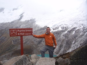
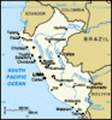
4750 m =15,584 feetThe journey from Huarmey to Huaraz was more difficult than expected. Though the two towns are close as the crow flies, there are no direct roads. I took a taxi first to Patavilca and the driver was completely insane. He drove about 100 MPH down the Panamerican highway (the speed limit is 55 KPH), passing others on blind turns and honking at everything, including the beat of Karma Chameleon, which blared on repeat. He then managed to take an exit ramp that was on the opposite side of the highway. The hour trip only took half the time, at least. After almost killing a few dogs and a whole group of people waiting for a colectivo, the car stopped and I paid my 1.50. I was happy to find a new driver to take me the rest of the way to Huaraz, which was another three or four hours. This driver was more patient and I arrived in Huaraz at around 3PM. I stayed at Edward´s Hostal, which was clean and central enough, and the helpful owner recommended that I go trekking with an organized group rather than alone, as it would be cheaper and safer. I walked to the city
center and found a four-day trek referred to as ¨Santa Cruz,¨ which goes through the heart of the Cordillera Blanca.
If you´re looking for something more challenging, consider heading south to Cordillera Huayhuash. The scenery is apparently more stunning, but the changes in elevation is more drastic and it´s a good bit colder. Also, the minimum number of days for a trek is 8 days, and 10 to 11 is preferable.
The cost for the Santa Cruz tour was 100 USD for me, but you should be able to get it for around 85 if you argue and haggle a bit. Deal with the company directly to avoid paying someone for commission. If you´re in good shape, you could easily do the hike in 3 days, but the third campground is under a picturesque waterfall; if you do it in three days, you just pass it by. The next morning we met at 6 AM to take a bus to the trailhead.
I highly recommend that you NOT take any trips through Mony Tours or through Montrek or Ganesa. Mony tours works through these other two, so if you deal with Mony, be sure that you ask
if the trek is through Montrek or Ganesa.
These companies managed to lose my pack within five minutes of my arrival. They put our bags into one taxi and the group members into another, and when we arrived at the bus, my pack was gone. Whether this was premeditated or just irresponsibility is unclear, but it contained over 400 dollars of clothes and equipment needed for the trek. The company then convinced me to go on the trek anyway, even though I didn´t have enough clothes for the extreme temperatures near the pass. They promised that the trip would be refunded either way, but that since the equipment and supplies were already bought, I might as well go on the trek and give them three days to look for my pack.
After the trek, I met with the owners of the company and they were dishonest and unhelpful. They kept trying to convince me that the U.S. would pay for all new equipment for me. I explained that I have no travel insurance that they were responsible for the bag, since I handed it over to them. They have no insurance, and they weren´t even willing to refund
the trip, even after telling me that earlier.
The police in Huaraz were helpful and kind, but it quickly became clear that there isn´t much they can do. Even after threatening Montrek·Ganesa that I would write to all major travel guides and post this information on this blog, they claimed that they didn´t have any money to give me. And they probably didn't, but their lack of concessions annoyed me.
Below is a description of the trek. Pretty much any company can offer a similar tour.
SANTA CRUZ TREK ... 3 to 4 days ... MODERATE TO DIFFICULT HIKING... MAX ALTITUDE: 4750 meters
DAY 1 ... 5 hours hiking
All the companies describe the first day as being very easy, but there are, in fact, some difficult uphill sections, and after four hours on a bus, my legs were tight. Most of the trail goes through indigenous farming communities, and local children follow along, hoping for treats. Huascaran National Park costs 65 soles as an entrance fee. Hold on to your ticket; you have to present it several times on the hike.
The first camp (see photo) is at around 3800 meters. It was all
set up for us when we got there, which didn´t exactly make me feel self-reliant, and didn´t give us much to do except wait for dinner. I had just come from sea level the day before, so I had some mild altitude sickness; some coca tea seemed to help. The food was excellent and the group tent was comfortable. The temperature dropped to just above freezing and near the middle of the night it began to rain. The guides weren´t expecting it since it´s the dry season, so they failed to put ground covers beneath the tents. When I woke up, everything was under water. This was pretty irresponsible of them, and I had to walk in cold, wet clothes.
DAY 2 ... 7 hours
The scenery of the first few hours is wonderful... snowy peaks abound and seem deceivingly close. In the hour and a half before the pass, the trail gets much steeper, and the altitude makes it much more difficult to walk... I could only walk for a minute before stopping to sit down. It began to sleet and then snow, but when I went through the narrow pass, however, it was well worth it. Below
was a turquoise blue lake, and the view of the peak was even more brilliant and surreal than on the other side.
After some time at the peak taking photos, we descended about 700 meters to the campsite. Again, it began to rain, but this time the guides put ground covers under the tents. By seven PM (bedtime for me), it was very cold, and I was only comfortable because I had my own sleeping bag as well as one provided by the company. When we woke up in the morning, the broken zippers on the tents were frozen shut.
DAY 3... 8 hours
The final day has the most drastic changes in scenery and vegetation. You begin at high altitude and descend past lakes, marshes, wild horses, impressive waterfalls, violent rapids, and cacti.
Advertisement
Tot: 0.047s; Tpl: 0.011s; cc: 11; qc: 26; dbt: 0.026s; 1; m:domysql w:travelblog (10.17.0.13); sld: 1;
; mem: 1.1mb


