Advertisement
Published: September 5th 2022

 Colca Canyon
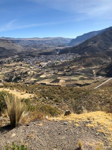
Leaving the valley.Another fairly early morning saw us on our way to Puno on the shores of Lake Titicaca, the largest lake in South America. It was an anticipated destination to experience another timeless Peruvian tradition, the Uros Islands and the people who have lived on them for centuries.
Our trip required a brief stop again on Yanque, to pick up the boxed lunches that Juanita's restaurant, The Alpaca Chef, had prepared for our journey.
In order to get to Puno we had to backtrack a portion of the way, and cross again the same high altitude passes we had braved before and access the Altiplano, or Andean Plateau, the most extensive high plateau on Earth outside Tibet. Its height averages about 12,300 feet and it's dominated by massive active volcanoes of the Central Volcanic Zone to the west. The Atacama Desert lies to the southwest.
But, although we stopped at the same place where we had enjoyed our boxed lunch two days before, our lunch destination this time was an even more idyllic location on the shores of Lagunillas at an altitude of 13,900 feet above sea level.
I have to admit that once we entered the plateau,
the scenery became rather unchanging and dull, broken occasionally by the sight of herds of the area's important livestock, llamas and alpacas, which graze on the immense plains.
I was relieved to reach the outskirts of Puno, although our drive towards the lakeshore and our hotel was underwhelming. But our hotel was lovely, with sloping terraces overlooking the lake and it's own private dock from which we would board the boat that would take us on our next adventure the following morning, the Uros Islands where, to this day, the Uros people maintain and live on these man-made islands, depending on the lake for their survival
Puno was established in 1668 and is the largest city in the Southern Altiplano. Established in the two miles of flat land between the shore and the mountains, the city has continued to expand upwards onto the hillsides. The poorer areas are high on the hillsides, with very steep and generally unpaved streets that cannot be accessed by cars.
Because of it's high elevation, Puno experiences lower temperatures than would be expected for its tropical latitude. Although at this high altitude, the rays of the sun are very strong the average

 Mirador de los Andes
Overlooking some of the volcanoes. annual temperature is about 47.1 °F and during the winter months from June to August, night-time temperatures usually drop well below 32 °F.
Planning to go into the city center the following day for lunch, we decided to explore the hotel grounds instead. On one of the terraces we ran into a few fellow travelers enjoying a happy hour sunset drink, so we decided to join them and soon had a lively group enjoying the comforts of a fire started by our attentive bartender and waiter. The sunset was beautiful, as was the view or the surrounding shores all lit up for the night.
Advertisement
Tot: 0.146s; Tpl: 0.012s; cc: 11; qc: 49; dbt: 0.0999s; 1; m:domysql w:travelblog (10.17.0.13); sld: 1;
; mem: 1.1mb

 Colca Canyon
 Mirador de los Andes


