Southwestern circuit


Advertisement
Published: January 8th 2006
Edit Blog Post

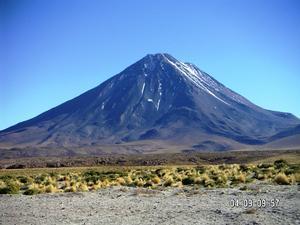
volcano Licancaburvolcano Licancaburvolcano Licancabur

The majestic and mystic volcano Licancabur (5,916 meters above sea level) is only 40 kilometers away from San Pedro de Atacama. The name means 'village hill', and it was venerated by the Incas, who carried out ceremonies and left offerings in the crater of its top.
After staying a week in groovy backpackers gathering spot San Pedro de Atacama we decided to do a tour to Bolivia. We chose Turismo Colque as they promised us that we could get a ride to Potosi. I wanted to do more than just a usual trip to lagoons and Salar de Uyuni. Early in the morning we said goodbye to Chano and squeezed into a van full of Japanese, Englishmen, Germans and even a couple from Poland. Hearing all those stories about beautiful landscape, a very severe frost and altitude sickness, we couldn’t wait to get on a 4WD at the Bolivian border... And we could wait to get back to San Pedro too!!!! it's true what they say about Bolivia, everything it's true. And Boliva is a dream, a perfect dream, but it could also be a nightmare.


Additional photos below
Photos: 25, Displayed: 22


Advertisement

Bolivian borderBolivian border
Bolivian border

Our tour took us from San Pedro up to the Bolivian border and Laguna Blanca in a small bus. The border is at 4,300m - the highest I have ever been. The lanscape changes quickly to dark brown gravels surrounded by enormous peaks and volcanos. In between this peaks the plain of Altiplano is surprisingly flat and there is complete absence of any vegetation.
Laguna Verde &LicancaburLaguna Verde &Licancabur
Laguna Verde &Licancabur

Laguna Verde in front of volcanos Juriques and Licancabur. The colour of these salt lagoons comes from the various micro organisms that have become dominant in each one.
Laguna VerdeLaguna Verde
Laguna Verde

Laguna Verde, a chilly aquamarine lake at 5,000 metres above sea level.
Laguna ColoradaLaguna Colorada
Laguna Colorada

Laguna Colorada, a dark red lake surrounded by a bleak landscape, which is a very popular resort by the rare James pink flamingos.
Termas de PolquesTermas de Polques
Termas de Polques

Soaking our feet in hot springs with 30 degrees. Termas de Polques, a sulphur pol at around 4,200 m. Clear air is still bitterly cold though. They even said we need bikinis for this trip. Hm, hm.
Sol de MañanaSol de Mañana
Sol de Mañana

A set of geysersat 4,970m, with its boilong mud pots, fumaroles and sulphurous atmosphere. The mud was different colours - due to sulphur, mercury and other minerals. Scary roaring and lava not that far beneath our feet.
4WD4WD
4WD

Our 4WD, me and 'polish vodka' couple sunbathing.
WCWC
WC

very modern toilet...
flora&faunaflora&fauna
flora&fauna

The Altiplano was formed millions of years ago by sediments washed down from the mountains to fill a deep valley that formed between two Andean chains as they were pushed up from the seabed. When the sea eventually retreated, it left behind giant salt lakes and saltpans. But as dry as it is, the Altiplano is hardly devoid of life. Animals and birds thrive here: Condors, herds of alpacas and vicunas, grey foxes and vizcachas all flourish in the ochre desert, and the algae-rich salt lakes support formidable colonies of all three species of South American flamingos.
Sunrise in UyuniSunrise in Uyuni
Sunrise in Uyuni

Our group has acclimatised by now (okay, there is still some odd headache). We spend the second night in a better place, still basic accommodation, no hot water and 6 of us in a tiny room, 5 stars though. Bolivian’s maybe!at 5 o’clock in the morning the Japanese started to scream “sunriz, sunriz”!This is what I saw.
Salar de UyuniSalar de Uyuni
Salar de Uyuni

Salar de Uyuni, a dead flat, white as you can imagine and simply immense. The mountains in the distance seem to be floating on a mirage. At 10,500 sq. km, is said to be the largest salt flat in the world, lying 3,653 metres above sea level.
Salt HotelSalt Hotel
Salt Hotel

Salt Holer, where everything is made of salt: chairs, beds, tables, walls...
Isla de Pescado Isla de Pescado
Isla de Pescado

Isla de Pescado is considered the largest "oasis" in a salt flat presented by such an isolated ecosystem. The island is populated by a number of cacti more than 8 m (26 ft) tall. Landscape is similar to those of Polar Regions where blues and whites merge together, and whose reflections generate images of inverted and horizontal saline hills over the horizon.
cactuscactus
cactus

Huge cacti only grow one centimeter a year, so they are pretty old. This one should be the oldest, don't you think?
 The Japanese &cactus The Japanese &cactus
The Japanese &cactus

Their new friend?
PotosíPotosí
Potosí

Perched at 4,000 metres above sea level in the shadow of the Cerro Rico mine mountain, Potosí, 550 km southeast of La Paz, is the highest city of its size in the world. Enriched by the Spanish for its seemingly endless supply of silver, today the city is bleak and impoverished but still spectacular for its setting and crumbling colonial churches and mansions.
marketmarket
market

Hm, what should I buy to cook for dinner?
market2market2
market2

Some spices? Herbs?
medicinesmedicines
medicines

Medicines? Medicine-man? No, thanks, I'm okay.
bus stationbus station
bus station

waiting for the bus to come.
bus station 2bus station 2
bus station 2

Indigenous people buying fruits and vegetables.
senorasenora
senora

Ups, I have forgotten what or who this statue is supposed to be representing.
abuelaabuela
abuela

While she was peacefully dreaming...
Where are we? Where are we?
Where are we?

...they threw us out of the bus in the middle of nowhere (you don’t want to hear the story of crossing Bolivian-Chilean border, from Bolivia’s side… 20 hours of waiting in the desert - no toilets, no water, no food!, when only 5 uf us could cross the border). I want to go home!


Tot: 0.107s; Tpl: 0.039s; cc: 9; qc: 56; dbt: 0.0456s; 1; m:domysql w:travelblog (10.17.0.13); sld: 1; ; mem: 1.1mb