Advertisement
Published: November 23rd 2011

 Ready to go
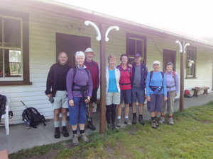
The gang lined up at the Cook House ready to leave for the first dayNear the Cook House is the old Homestead originally built as a cottage for the head shepherd of Glens of Tekoa station in 1882. Since then it has been added to over time and now appears badly in need of renovating to a cohesive dwelling in it's original style. The Shand family now live in a more modern home near the old homestead.
We left the station homestead and farm base and headed up the valley along the Dove River flats with views of the surrounding mountains and lower hills covered with broom, matagouri and manuka scrub. It is easy to see how the farm of 7100 hectares has not been productive. Much of the good land is covered with scrub whilst the higher hills are alpine and non productive. With lamb and wool prices down over the past many years there would not have been the incentive to clear the land in order to make it more productive. Now, it is primarily the hiking visitors, beekeeping, forestry, some sheep and cattle grazing that is keeping the farm continuing. Perhaps now with lamb and wool prices at a more economic level, the land could be made more productive.
From

 On the river flat
Linds and I on the river flat heading along the Glencoe Riverthe Glencoe Downs we walked along the Glencoe River alongside a large Douglas Fir forest (planted 1960s) before walking steeply uphill through the forest to the Summit at 750m for lunch where we had grand views over the surrounding country side of deep valleys and river flats and high mountains to the Waikari Basin in the south and the Lewis Pass mountains in the north. The rocks in this area are the greywacke of the Torlesse Supergroup which means they are indurated sediments laid down in a deep syncline off a large land mass (Gondwanaland) during the Jurassic and Triassic periods before being uplifted to their present position. There did not appear to be any fossils but the upturned beds of mudstone, siltstone and sandstones were easy to see affecting the landscape.
We walked along a ridge before walking steeply downhill to the Mandamus River (the boundary) to Gills Block, named after a sheep stealer. Finally we crossed the river and then followed the track to the clearing of the "Cricket Pitch" and then on to the destination of the Valley Camp Hut. The walk had been 14kms ending at a basin surrounded by forest and hills in the

 Lunch at the Summit
Lunching at 750m which is the highest part of the three day walk. From here you see the Waikari Basin to the south, the mountains towards the Lewis Pass to the north and the nearby Organ Range (named because of the erosion on the bedding planes)middle of which was the new hut which had been rebuilt from the earlier one built in 1933. Across the nearby stream was another small historic and self contained musterers hut. The main hut consisted of a large room with double and single bunks at one end and a large living area for recreation. Between the two was a large fireplace where a fire was lit as for yesterday. Lighting was provided by solar panels and water heating from LPG. There was a marvellous huge outside shower which we all reveled in after the long walk. Lindsay and I stayed across the stream in the smaller hut.
The "other four" BBQ'd a dinner of sausages and ham steaks followed by a dessert of creamed rice and peaches followed by lamingtons. Two bottles of sparkling wine had been provided by the Shands and was most appreciated. Following dinner was the obligatory Uno game again which as usual caused much laughter and outrage.
Whilst Linds and I had a lovely quiet night despite the wind getting strong, the others had a night of a banging roof plus a sheet of iron under the hut lifting in the wind and banging
against the floor much to the wrath of Dougal.
Advertisement
Tot: 0.337s; Tpl: 0.01s; cc: 14; qc: 64; dbt: 0.1194s; 1; m:domysql w:travelblog (10.17.0.13); sld: 1;
; mem: 1.1mb


