Advertisement
Published: January 4th 2011

 Routeburn Track
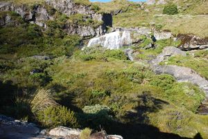
Waterfalls just above Routeburn Falls HutEarly to bed, early to rise. I was up by about 6:30, and after a quick bite (english muffins, peanut butter, and honey) it was time to hit the trail. The weather was fantastic again. The track climbed steeply for the first twenty or thirty minutes before evening out to an alpine valley. Stunning. The scenario kept repeating, revealing more and more of the valley. Then another steady climb brought me to Lake Harris, the source of the Routeburn and more amazing views.
I left the lake behind and a short while later came to the day shelter at Harris Saddle (elevation 1255 metres). After a short break at the saddle, I left my heavy pack behind and headed up Conical Hill (elevation 1550 metres). The following excerpt is from the trail guide:
This walk is not recommended in snow or adverse weather conditions. A short, steep, rocky climb from the Harris Saddle up Conical Hill gives superb view of the Hollyford Valley through to Lake McKerrow, Martins Bay and the Tasman Sea.
Yup. It was steep. It was rocky. The views were amazing.
After scrambling back down to the saddle and having lunch, it was time
to grab the full pack and keep moving. I had about another four hours of hiking before reaching Mackenzie Hut (elevation 800 metres), down a gully, along the Hollyford face (very exposed...not a place to be in high wind or rain...but again, amazing views), and finally down into the bush through a series of switchbacks. I just reached the hut as the rain started. Good timing.
Water. Supper. Warden's talk. Bed. I had been on the trail for over nine hours. Yes. Sleep is a very, very good thing.
Advertisement
Tot: 0.109s; Tpl: 0.012s; cc: 8; qc: 50; dbt: 0.0569s; 1; m:domysql w:travelblog (10.17.0.13); sld: 1;
; mem: 1.1mb

 Routeburn Track


