Advertisement
Published: March 2nd 2009

 258
258
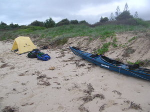
Evans Head - Note 'water gear bag' behind tent - went missing overnightDays 26=>30: Noosa (26 miles), Inskip Pt. - beginning of Great Sandy Straight (48 miles), Hervey Bay - Scarness (52 miles) (3 days)
In my foggy mind this morning, I can't remember the paddle into Noosa, but my notes tell me that I started at 1am and was there by 8am. I do remember arriving, because I wanted to note the depth of the water in the river mouth I was entering (I stayed at a caravan park inside the river about a mile or so). The 2nd year I stayed there also - and on departing at my normal time (dark, am), I navigated myself onto a sand bar trying to get out - it seemed like a maze of channels to navigate to get me out. (after checking with the locals - the easy way out was just to follow the outside shore on the right - worked great)
Noosa to Inskip: A longish paddle - to be done in good weather, there is a long bight that I wouldn't want to land in in surfy weather.
There was a 'fair' southerly blowing. The swell was quite manageable - but I had worries about entering the Wide

 259
259
Byron HeadBay bar (as I recall my readings in the Pilot (from years ago) - there are warnings about this bar, the chart (GPS - BlueChart) says - 'always breakers').
I used the same method to enter this bar as I did with the Jumpinpin bar - I headed for the shore - just outside the surf - on the south side of the bar. It was the same situation - though less sizeable breaking waves - I got quite wet - but it was an easy entrance (had I come in straight down the middle (though I wouldn't have because the tide was still going out) - I would have encountered about a mile of breaking waves).
Inskip to Hervey Bay:
My sleep at Inskip Pt was the most pleasant of the trip - very dark, comfortable ground, and the thought of a 'safe' (though long, it would be calm waters) paddle the following day.
The paddle up Sandy Straight (between Frazer I. & mainland) was a bit of an ordeal.
First of all - due to my conservative nature - I started too early for the flood current.
Since I started too early, once I did start enjoying

 260
260
Kingcliffthe 'free ride', I got to the mid-point far too soon, so I had a few hours of battling an opposing current.
Then, just as I started to enjoy the ebb, which should have pulled me all the way up to Hervey Bay, a northerly breeze came up, then freshened after about an hour. (probably about 15mph - for me (at my speed) enough to negate the benefit of the ebb current).
Complicating matters - I made the decision to cut through some channels and go into Urangan (town on far east side of Hervey Bay). The problem was - the GPS was not quite right I got stuck high and dry on a mud flat. I had about a 1/4 mile (equals 2 mile carry (one way) - 4 loads to and fro) portage to high water.
Once I'd completed the portage, the tide had changed, and I got to fight a flood - that I should have beaten. (total for the day: 4:15am - 11:30pm with a 3 hour break in Urangan). I think I get a grade of 'D' for navigation today (but maybe a B for stamina).
I'm now in a Scarness (town in the middle

 261
261
Gold Coastof Hervey Bay) caravan park. (police kicked me off the beach at 2:30am - where I set up the bivy (at 11:30pm).
I'll be off in the morning next - for parts north.
NOTE: Hervey Bay: It is pronounced 'Harvey' - as in the rabbit (though they don't care much for the rabbit around here - now if only the rabbit had a taste for cane toad - they might appreciate the little buggers a little more).
Advertisement
Tot: 0.069s; Tpl: 0.011s; cc: 10; qc: 45; dbt: 0.0398s; 1; m:domysql w:travelblog (10.17.0.13); sld: 1;
; mem: 1.1mb

 258
258
 259
259
 260
260
 261
261


