Advertisement
Published: February 1st 2008

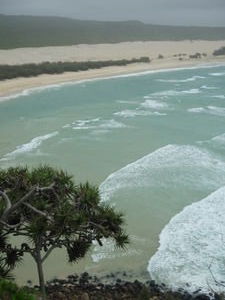
 Indian Head View Point.
Don't go swimming here, lots of sharks and sting rays. When Scott first told me about wanting to go to Frazer Island I was a little turned off by the presentation. Simply put, it's the largest sand Island in the world. Some say it contains more sand than the Sahara desert. As well as that, because of the lay out of the ocean's geography around the island (close to the deep ocean trench) it is a prime breeding ground for bull sharks and tiger sharks. Which are known for being very aggressive. Not to mention an over abundance of sting rays (Steve Irwin Killers as we've heard them called down here). Everyone that ventures to the island is told never to swim in the ocean, period. So why in God's name must we trudge out to the world's largest sand Island when we can't even go in the ocean. Odd for sure.
So I am thinking to myself "great, a big hot sandy island surrounded by so many sharks in the ocean you can't even go down to the beach to cool of in the waves." But Frazer Island turned out to be that plus a lot more. When I discovered the island was pock marked with huge

 Remember this?
Mrs Walker. (Lake Birrabean).fresh water lakes I was sold and wanted to go. I was ready for fresh water. I didn't even care anymore that we wouldn't be able to swim in the ocean.
Since the island is fairly isolated there are only three ways you can get on it. You hire a guide, rent a car or you find a company that arranges a random group of ten people and provides a car to get there. We considered each one of these options. And finally went with going with a guide. We wanted to rent the vehicle but it was going to be too costly. We thought of doing the random group thing but didn't want to risk paying a bunch of money to be stuck with a group of people we totally hate being around for the next few nights. The random group thing could either work out great or be hell. In the end we opted for the guided tour of 3 days, 2 nights.
Our guide was an Aussie named Shayne. He picked us up in vehicle called a "truss". Which means it is a cross between a bus and a truck, hence the word
truss. It was a big blue thing up on jacked up shocks and tires. Then we headed off to the island along with a few French, Croatian, Danish and Austrian travelers.
No vehicles go on to Frazer Island unless they are four wheel drive. Everything is sand so the traction is terrible. Most of the inner island is reached by driving around on 75 km long beach. Then through very bumpy back roads. The most important part of driving around the island is to pay attention to the tides. Everyone is supposed to have a tidal chart with them at all the times. If you get caught on the wrong tide on the beach you forfeit your vehicle to the waves. It was one of the other reasons we decided to leave the driving up to some one who was used to dealing with the tides. At the end of the trip we stopped to see the "Wall of Shame" in which people have taken numerous pictures of wrecked, sunk, or otherwise totally screwed up rental vehicles.
When we first drove out on to the beach it was approaching high tide. Fraser Island has an official

 Remember this?
Tomorrow tomorrow land. (Lake Wabby). legal road that is right on the beach. The tricky part being that the tide comes swinging in pretty quick and can cause your car/truck to be flooded if your in the wrong spot at the wrong time. There's even a Hall of Shame in which you get to view photo's of flooded, flipped, and otherwise totally ruined vehicles that got caught in the tide.
As we moved off of the ferry we encountered a large line of people waiting for the tide to go down so they could continue off. So with this in mind our bus driver went flying by the rest of the parked vehicles as he decided it would be fun to race the tide. Granted we were in a big 4 wheel drive Truss that was jacked up higher then most other vehicles. Our view of the beach was a wall of sand 8 feet tall on our left side with nothing but sand and waves on our right side. We learned right away that it wasn't Shayne's motto to drive slow. Strangely enough there's something oddly relaxing about ripping across the beach in a 4 wheel drive Truss with a sand bank to
your left and lapping ocean waves to your right.
(clover)
So what makes the largest sand Island in the world so special? For starters it would have to be the water in the lakes. We had the pleasure of spending several hours at lake Birrabeen which has got to be one of the clearest lakes we've ever seen. There was a light rain coming down on us when we got to the lake but that didn't stop a one of us from having the time of their life. Clover seemed to morph into a friendly lake otter on the spot as she dove into the lake. For the next hour or two you could see her skimming through the water in glee as you caught a glimpse of her foot or arms. Her frowny face swiftly turned upside down.
If life is composed of million different moments that slide from one to the next then truly swimming through the waters of Lake Birrabeen will stand out to us as one of those perfect ones. The rain only made this more paramount as we realized how much fun we were having regardless of the rain. Not to mention

 The lake Flounder.
Hobbits mostly sink, mostly.we were loving having a day off with no sun block.
Side Note: The skin cancer commercials in Australia can be a bit gnarly at times. We were wolfing down some noodles while watching T.V. when all of a sudden we were accosted with doctors cutting out slabs of black flesh and fat that they placed in a petri dish. Watch with caution.
Of mention, is the wrecked ship the Moheno. The Moheno has a whole history that would take to long to discuss here. Needless to say, the old passenger cruiser that served as a medical boat during D-day had crashed while being towed and ended up washing up on shore along Fraser Island. Stopping along our journey, it was amazing to see how quickly the sea was reclaiming the old iron side boat as we inspected the pitted iron and rusty sides. It was both odd and yet strangely serene to watch the waves crashing through the old steamer's skeleton. Water and oxygen. The keys to life and yet the very agents that break life down so quickly. I could not help but wonder if the ghosts of old soldiers who had died while sailing from
France back to England during D-day ever wondered these sandy shores waiting for their final ship to join them. One of the coolest things we were told about the Maheno had to do with a couple that got the very cool idea to have a wedding on board the crashed ship. Of coarse this in the early days when the ship had just washed up on shore and was still in pretty good condition. The procession of the wedding was walked to the tune of the ship's original organ (how cool is that!). We had the chance to glance at some of the photos of the wedding bringing us back in time to when everyone was standing on a tilted deck with crashing waves on the broadside while they said their vows. Very cool. I'd give that a 9.5 on my wedding Richter Scale.
We arose early on the last day of the Island and went out for a little hike to Lake Wabby. Lake Wabby is just a couple of km from the beach and all in all is nice little hike. The fun part just begins however when you get to Lake Wabby since it's got some
very large sand dunes around one of it's sides. Like a good tour guide, Shayne brought an old boogie board for some fun with momentum. Clearing out a path at the highest sand dune we built a little ramp at the base of it. Watching our guide he then leaped onto the board and went flying down the dune face first to go ripping right off the little ramp and into the water. Of coarse we had to give it a try (had to get the group peer pressure going to clover into it, but in the end she gave in) since there's always something to be said for gravity, water, and moving fast. Hopefully the video clips we posted turn out.
Like all things though, the Fraser Island express ended before we had really grasped that it had begun. From the crystal clear waters of Birrabeen to the rusty remains of the Maheno to speeding down the sand dunes on a boogie board we simply put, had a blast of a time on the Fraser express.
(Scott)
Advertisement
Tot: 0.121s; Tpl: 0.015s; cc: 9; qc: 59; dbt: 0.0682s; 1; m:domysql w:travelblog (10.17.0.13); sld: 1;
; mem: 1.2mb


Steve Waggoner
non-member comment
Curious?
Sounds great all. So when are you guys going to see that Mother Big Rock with all the juju? The one in all the post cards that the aborigines like so much? Ever think about island hoping for some good WWII vintage diving? Guadalcanal and such. Of course my idea of distance is exagerated by all maps here placing America in the middle and I think they tend to cut through the region where your at. Suppose maps the Aussies use puts their country in the middle eh? Wonder what Canadian maps look like (ponders America being at the bottom much like Mexico is on American maps). Well, tons of snow, snow, snow and more snow. I've taken to wearing my sunglasses even though the sun isn't out just because everything is so damn white. Still working and planning the wedding. Kate's doing well and we're having a great time...in the snow. Love you both and take care of yourselves. Keep sucking in that gut Scott, it might go away. Steve