Advertisement
Published: April 21st 2022

 Let's go to Sugarloaf Mountain
Between Patrick, Ruby, Cheraw and McBee in Chesterfield County, South Carolinaby
Gallivanting Like a Royal, Duchess DJ Love South Carolina is the home of my southern accent. My trademark, as I call it. Growing up, many Saturdays were spent with grandpa, who would take all of us grandkids over to Sugarloaf Mountain to spend the day. This unusual hill located in the Sand Hills State Forest of Chesterfield County South Carolina is thought to be created from an asteroid blast and home to lost confederate gold. The “mountain” is just across the dirt road from the smaller horseshoe mountain. Sugarloaf gets its name from looking like sugar on its white top. Horseshoe is named by its shape which looks like a horseshoe. You will find interesting rock geology, hiking and horse trails, camping, fishing, birdwatching, wildlife, and scenic piney landscapes including a 1.7-mile nature trail, and primitive camping sites.
TIP: Be sure to spray yourself for the insects.
A lot of history is rooted in this unique recreational area. My grandfather shared stories of lost confederate gold hidden in this forest that his grandfather had passed down to him. We would go exploring seeking
the lost treasure. Supposedly a chain was buried with the gold so that it could be found later in the sandy soil. Grandpa thought the government made the area a park to protect the gold, if found. Nearby Cheraw was nicknamed "the Prettiest Town in Dixie" because General Sherman of the Union Army liked it so much. He called the town a treasure house due to all the State’s valuables stored there during the civil war. It is believed that in April 1865, the Union Army was about to take the Confederate Capital, Richmond Virginia, so the southern government officials quickly loaded and shipped by train and wagons the wealth to Georgia. There were many crates and barrels filled with gold and silver coins. Grandpa said the money made it from Richmond, Virginia to Cheraw, South Carolina. As the Union soldiers were nearing the Confederate convoy making its way to Georgia with the stash and with the train route becoming compromised, all was loaded on the wagons and hauled away from the tracks in Patrick, South Carolina to avoid the Union soldiers. However, the heavy, overburdened wagons became stuck in the sandy hillside and the journey with the heavy containers
became impossible, so the cargo was buried in the Sandhills forest. It’s recorded that Jefferson Davis made it to Georgia, but the $54 million fortune never did. Grandpa firmly believes it lies in the sandy land near Sugarloaf Mountain. It makes sense since the convoy would have taken the Old Wire Road, the telegraph line, and the train runs from Cheraw to Columbia and the nearest stop to Sugarloaf Mountain is Patrick, home of the Pine Straw Festival. Since the mountain rises way above the tree line in this flat, sandy area, it would be a great market for hidden treasure. Another nearby town, Ruby, is known as the jewel city, so the area is rich in history along with this hidden pearl, Sugarloaf Mountain.
Legend has it that Paul Bunyan was from South Carolina. During one of our hot and humid summers, he went North to help baby babe stay cool. On the way, crossing through the Sandhills, baby babe got stuck in the sand, so he kicked her loose and Sugarloaf Mountain came into existence. The Horseshoe Mountain is where his stomped foot landed, throwing the sand over to form Sugarloaf. There are nature trails, bird blinds,

 Sugarloaf Mountain Riding Area
Lake and Recreation Area Sandhills State Park. Horses Welcome!porta potties, covered picnic areas and a fishing lake available for day campers. While taking photos for this blog, wild turkeys and deer crossed my path. A squirrel ran up the tree and plenty of bees pollinated the blooming flowers. Butterflies danced in the air and birds sang in the breeze. This is a special place. Be on the lookout for the fox squirrel; he has a raccoon looking face. Hiking either the Horseshoe or Sugarloaf is an easy climb, great for kids. Over the years erosion has reduced the height of the mountains. The red cockaded woodpecker, southern bald eagle, pixie moss, and the pine barren tree frog are some of the rare plants and animals making the area home.
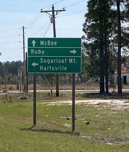
Since you know about my childhood stomping ground now, come for a visit. South Carolina has smiling faces and beautiful places. It is even stated on the license plates. From Charlotte NC heading to Myrtle Beach SC, Sugarloaf is just a short detour from the route near McBee which is about an hour and half from Charlotte, the Queen City. Coming from Columbia SC take US 1 North for about an hour and half, then turn right on
Hwy 109/Hartsville-Ruby Road to the site. Chesterfield County is steeped in history, beauty, and memories…make it one of yours.
Hope you enjoyed my blog. I’d love to hear from you! I’ve traveled all 50 states and plan to post more of my adventures sharing the love as I go, one heart at a time. Currently I am working on details for my Cheraw and Chesterfield Small Town blogs coming out next month.
Follow me on Tripadvisor.com/Profile/DuchessDJtravels @DuchessDJtravels for my trip reviews and photos, or Facebook: DuchessDj Love and Instagram: duchessdjlove. South Lake Tahoe, Big Island Hawaii, and Sedona are all in the works for travel this year. Stay tuned in…
Advertisement
Tot: 0.286s; Tpl: 0.016s; cc: 11; qc: 50; dbt: 0.1243s; 1; m:domysql w:travelblog (10.17.0.13); sld: 1;
; mem: 1.1mb


