Advertisement
Published: October 2nd 2008

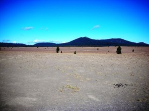
 Pumice Desert
Up to 50' of ash from the eruption, still very little vegitationWe had read an article about Crater Lake in one of our RV magazines about 8 years ago and had decided definitely to put it on our “bucket list.” Thursday was my day to add to my bucket. I am staying in La Pine which is at + 4000’ elevation. I don’t know what I was expecting, certainly not what I found.
The land around the park is very flat so the first thing I saw when I got in was the Pumice Desert. Then I started to climb until my ears started to “pop.” There was a scenic overlook pull in and a lot of people were there so I drove in - then gasped. This has to be one of the most beautiful places in this country.
According to the info I received “The Lake rests in the shattered remnants of a volcano called Mount Mazama, which erupted and collapsed into itself 7700 years ago.” At the time of its eruption the volcano stood at 12000’ and had been an active volcano for at least half a million years before. Ash from Mount Mazama has been found scattered over eight states and three Canadian provinces; about 5000 square miles

 Downward Flow
Taken from about 6000' up the side of the mountainwere covered with six inches of Mazama’s ash. “In the Pumice Desert ash lies 50’ deep. The eruption produced more than 150 times as much ash as did Mount St. Helens on May 18th, 1980. The Mazama magma chamber was emptied and the volcano collapsed leaving a huge bowl-shaped caldera. The high mountain was gone. As volcanic activity subsided water began to collect. For the past 5000 years the volcano has not stirred. Springs, snow and rain began to fill the caldera. As the lake deepened and widened, evaporation and seepage balanced the incoming flow. The depth now varies less than three feet annually in this, the Nation’s deepest lake.”
I had been staggered by the sight of Mount St. Helen’s a couple of weeks ago; the 1980 eruption reduced the height of the mountain from 9677’ to 8363.’ Mt. Mazama was 12000’, I was now standing on the rim at 7,000’ and the lake was 1000’ below my view point and at its deepest point is 1943’ deep. Just mind blowing.
Advertisement
Tot: 0.053s; Tpl: 0.009s; cc: 11; qc: 26; dbt: 0.0349s; 1; m:domysql w:travelblog (10.17.0.13); sld: 1;
; mem: 1mb

 Pumice Desert
 Downward Flow


