Advertisement
Published: August 7th 2007

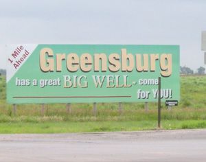
 Greenburg Welcome Sign
This sign sits just a mile west of town on HWY 54.I was in CO on a riding tour with HOG (Harley Owners Group). On the ride home from Breckenridge CO to Kansas City, KS., I decided to take the long way. That route would be to NM, then OK, TX and back into KS. I am on my 2005 Harley Davidson 883 Sportster. My favorite form of transportation. I love Hwy 54 that goes through the southern part of KS, its like Route 66, except the stuff on Hwy 54 is still open.
Greensburg, KS., is located on this stretch of Hwy 54. So I pulled over to observe the progress of recovery of this town. It was hit by a tornado the first week in May. May 4th I think. The President, FEMA everyone seems to be helping. A little background. Greensburg was/is the county seat for Kiowa County. It is the home of the worlds largest hand dug well, at 109 feet deep by 32 ft wide and also home to a 1000 lb meteorite. Kind of like that Route 66 stuff I like.
The fields leading into Greenburg were looking great. Some farmers are going to be happy if that continues. Entering Greensburg, I was amazed

 Greenburg City Limit Sign
Here is Effie at the sign. I stopped and took a ABC photo.at the total ruins. I thought that by this time rebuilding would have started. It has been 2 months since the tornado, but the town is still piles of debris everywhere. The road is littered with boards, tar paper or other construction materials that were torn away from the houses and buildings in the area. I had to be careful to not pick up a nail in my tires. There were some groups of people working, one was cleaning a pile of bricks, others were filtering through debris on the ground. A shocking sight was the Kiowa County Memorial Hospital that was right off the highway. I don’t know if this was the original site of the hospital, but the new one is 5 tents. All the streets were labeled. Originally after the tornado, it looked like cardboard signs were put up, now a board with black letters and white background is nailed on top of the other markers.
The rest of the ride will be posted in a different blog, this one I just wanted to put the photos from Greensburg by themselves. God bless them and lets all help them.
I visited Greensburg again in 2008.....

 Cannonball Stage Route
Hwy 54 is the original route of the Cannonball Stage line. There is a historical marker east of Greensburg that tells about it.Here is the blog:
08 Greensburg Kansas
Advertisement
Tot: 0.136s; Tpl: 0.019s; cc: 11; qc: 36; dbt: 0.0659s; 1; m:domysql w:travelblog (10.17.0.13); sld: 1;
; mem: 1.1mb

 Greenburg Welcome Sign
 Greenburg City Limit Sign
 Cannonball Stage Route


