Advertisement
Published: September 30th 2017

 On Biscayne Bay
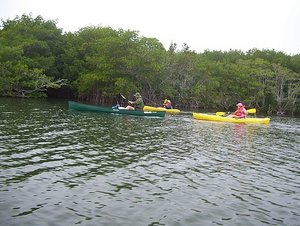
Our main activity in Biscayne NP was to rent a canoe and take a guided canoe trip into Biscayne Bay. The folks in the two kayaks were the only others on the tour. The person in the green canoe is the park ranger/guide on the tour. Geo: 25.4533, -80.3386
On our third day of this trip, we visited Biscayne NP. We only spent one day in the park so not nearly as many pictures on this page. After our canoe tour in Biscayne Bay, we walked along a bayfront boardwalk and out a short jetty and back and that was it for us in the park. The park does have one long hiking trail, but it is on Elliot key and is only accessible by boat, and it was too far to paddle to. The hiking trail is actually a highway that was built before the park was established as a National Monument in 1968 (it became a national park in 1980). The highway, nicknamed 'spite highway', was built by a group of landowners who hoped to prevent the park from being established so they could develop it similar to the development that occured along most of the Florida coast. Fortunately it didn't work.
After visiting the park we drove north, along the coast in the direction of Miami and ran accross a Miami-Dade County park called 'Black Point'. This park is on the shore of Biscayne Bay and the actual shoreline is still part of the national park,

 Mowry Canal
In Biscayne NP, we paddled up this canal that flowed into the bay. The ranger is in the canoe ahead and just over his head you can see the gates used to control flow of fresh water into the bay. There are a bunch of these canals and, while probably necessary to provide fresh water for the population (which grows by 800 per day), it wreaks havoc on the marine life used to steady salinity levels. The canoe trip was fun but, as you can see, overcast with a little rain.though the county park begins just inside the shoreline and includes a trail out along a breakwater that extends into the bay. This trail, including the portion in the county park itself, was a couple of miles long so Anne got her walking in for the day here. It is a nice park but, unfortunately, just inland from the park is Miami's Mt. Trashmore - a huge manmade mountain of garbage that is the area landfill. The prevailing winds at that time of day were from the West and the smell was not a nice one.
Enjoy the pictures.
Advertisement
Tot: 0.11s; Tpl: 0.011s; cc: 7; qc: 44; dbt: 0.0691s; 1; m:domysql w:travelblog (10.17.0.13); sld: 4;
; mem: 1.3mb

 On Biscayne Bay
 Mowry Canal


