California Central Coast


Advertisement
Published: March 7th 2008
Edit Blog Post

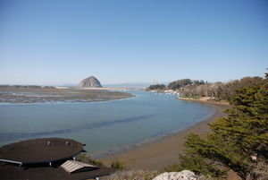
Morro Bay, CaliforniaMorro Bay, CaliforniaMorro Bay, California

Low tide in Morro Bay. The roof of the Natural History museum is to the left and town harbor to the right. Morro Rock marks the entrance to the harbor.
We are coming to the end of a 5-day stay at a state park in Morro Bay, a part of the Central Coast of California that seems to have everything a reasonable person could want. First, the scenery is drop-dead beautiful. The entrance to the bay is marked by Morro Rock, a 23 million-year-old volcanic plug, the first of some nine that are arranged in a line between Morro Bay and San Luis Obispo. Morro estuary is considered to be the least disturbed and most important saltwater marsh in the state and provides critical habitat for thousands of ducks, geese, and shorebirds. So, the birding is great. We have been kayaking every day in the bay and estuary, accompanied closely by several species of loons and grebes, all kinds of sea ducks, and sea otter and sea lions. A pair of peregrine falcons can be regularly seen at Morro Rock, and there is a heron “rookery” next to the state park. Wow!

The campground is situated in a mixed woodland planted by the Civilian Conservation Corp in 1930 and is crawling with white-crowned and golden-crowned sparrows and California and spotted towhees. The fresh seafood is cheap and very good, the
Morro Bay State ParkMorro Bay State ParkMorro Bay State Park

The state park is in the wooded area in the picture foreground. Part of the Morro Bay estuary is also shown.
crowds are scant, but the weather is boring—highs in the low 70’s, with sunny skies, and 10% rain chances everyday for the 10 day forecast. Who needs the weather channel? The state park not only includes the campground and lots of trails to beaches, the estuary, and several of the volcanic plugs, but also a full marina, a restaurant, and an 18 hole golf course (golf clubs are the only thing we did not bring along!). Lynn noticed a powerboat at the marina that was called “Sailbad the Sinner”, and thought that was pretty funny. Adjacent to Morro Bay state park is another, much larger state park called Montaña de Oro, which has little camping but miles of trails and beaches. We spent yesterday driving and hiking around there. Also, a Small Wilderness Area Preservation (SWAP) natural area called the El Moro Elfin Forest Natural Area preserves a section of unique coastal dune scrub habitat and has extensive boardwalks and trails adjacent to the estuary. We decided that this travel blog entry should be largely photos, since words are inadequate to describe this place. Saturday we leave Morro Bay for Big Sur.


Additional photos below
Photos: 21, Displayed: 21


Advertisement

Morro Bay EstuaryMorro Bay Estuary
Morro Bay Estuary

One of the largest and least disturbed estuaries in the state. Ducks, geese, and many shorebirds were abundant. Seen here from the Elfin Forest Natural Preserve.
Morro Estuary from Black RockMorro Estuary from Black Rock
Morro Estuary from Black Rock

Seen at almost full high tide.
State Park Marina and CafeState Park Marina and Cafe
State Park Marina and Cafe

Sailing in the bay must be limited by the tides, which are substantial.
State Park Golf CourseState Park Golf Course
State Park Golf Course

Although we do not golf, it seemed like a very nice course.
Volcanic plugsVolcanic plugs
Volcanic plugs

Starting with Morro Rock, there are eight additional volcanic outcropings in a line between Morro Bay and San Luis Obispo.
Kayaking on the BayKayaking on the Bay
Kayaking on the Bay

At low tide there was a lot less water available for paddling, something we needed to take into account.
Downtown Morro Bay from the Water.Downtown Morro Bay from the Water.
Downtown Morro Bay from the Water.

Fresh seafood was available at several fish markets.
Lynn and a Common LoonLynn and a Common Loon
Lynn and a Common Loon

The loon is off the port-side of the kayak. Getting close to marine birds and mammals was easy.
Elfin Forest Natural PreserveElfin Forest Natural Preserve
Elfin Forest Natural Preserve

The Central Coast of California is quite dry, about 15 inches of rain per year, but another 10 inches per year comes from water vapor in sea mist.
Ceanothus at the Elfin ForestCeanothus at the Elfin Forest
Ceanothus at the Elfin Forest

A dominant scrub with white flowers is also known as buckbrush and California lilac.
California PoppiesCalifornia Poppies
California Poppies

Just starting to come into bloom.
Under a Canopy of Pygmy Oaks--Elfin ForestUnder a Canopy of Pygmy Oaks--Elfin Forest
Under a Canopy of Pygmy Oaks--Elfin Forest

A unique form of coast live oak ([i]Quercus agricfolia[/i]), these oaks at about 200 years old.
Fuscia-Flowering GooseberryFuscia-Flowering Gooseberry
Fuscia-Flowering Gooseberry

Anna's hummingbirds were all over these plants, but difficult to photograph.
Morro Rock from Black HillMorro Rock from Black Hill
Morro Rock from Black Hill

Black Hill is the volcanic plug nearest Morro Rock just out of town.
Morro Rock from Black HillMorro Rock from Black Hill
Morro Rock from Black Hill

Another view of Morro Rock!!
View of Morro Rock from Montaña del Oro State ParkView of Morro Rock from Montaña del Oro State Park
View of Morro Rock from Montaña del Oro State Park

Located seven miles south of Los Osos, this park provides hiking access to the sand dunes forming the sea barrier to Morro Bay.
Secluded Beach, Montaña del Oro.Secluded Beach, Montaña del Oro.
Secluded Beach, Montaña del Oro.

Dogs were allowed on this beach, which Moxie appreciated.
Power Plant, Morro Bay, CAPower Plant, Morro Bay, CA
Power Plant, Morro Bay, CA

Morro Bay even has its own gas-fired power plant. Sirens in town warn of either power plant problems or tsumanis.
Dinner GuestDinner Guest
Dinner Guest

What do you mean our dog is spoiled?


Tot: 0.086s; Tpl: 0.012s; cc: 11; qc: 53; dbt: 0.0508s; 1; m:domysql w:travelblog (10.17.0.13); sld: 1; ; mem: 1.1mb