Advertisement
Published: June 28th 2013

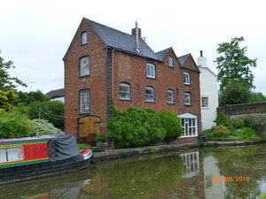
 Canalside at Gnosall.
Could be interesting layout inside.0 locks, 248 in total.
The rain from yesterday afternoon continued overnight and for the first part of this morning so we listened to Hugh Laurie on
Desert Island Discs before shopping and taking on water when the rain had virtually stopped. Something I forgot to mention yesterday – we went through a short tunnel which had been rough hewn through the red sandstone – no brick lining at all - the surface was very uneven and we had to watch our heads.
Fewer and shorter cuttings today which was a relief. First area of interest was the Shelmore Embankment, one mile of endless grief and expense to the canal company in general and Thomas Telford in particular. It was only necessary because Lord Anson of Norbury Park didn't want his pheasant covert disturbed or his farmland split up so the 40' high embankment was built to the west across lower ground. Hundreds of thousands of tons of soil and marl were transported from the Grub Street cutting but the bank shifted and collapsed time and time again. By 1834, Shelmore Embankment was the only unfinished section
of the whole canal. It was not until 1835, after 5 ½ years' solid work and well after Telford's death that the embankment was finished by William Cubitt. There are flood gates at each end, to close off the channel in case of a breach. These were closed each night during WW2 as a precaution against bombing.
We stopped at Norbury Junction where there are many facilities for boaters (pub, cafe, chandlery, repairs, water, refuse and
showers - bliss) and a huge number of boats line the cut. The Newport branch heads off at this junction; only the first 200 yards remain in water although there are hopes of restoration. The lock at the end (originally the first of many) is now used as a dry dock.
Both before and after the junction there are extensive views westwards to The Wrekin.
Oh look! It's raining again.
Advertisement
Tot: 0.116s; Tpl: 0.013s; cc: 11; qc: 31; dbt: 0.0662s; 1; m:domysql w:travelblog (10.17.0.13); sld: 1;
; mem: 1.1mb

 Canalside at Gnosall.


