Advertisement
Published: January 2nd 2023

 Teufelsmauer I
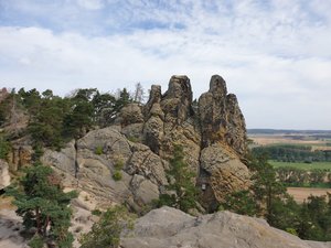
Devil's Wall. This part of the rock formation is called "Hamburger Wappen" ("Coat of Arms of Hamburg") because it looks like the coat of arms of the city of Hamburg.In August 2021, I needed a holiday, and I thought a hiking holiday would be the best thing because I usually recover and recharge best when I go hiking. However, because of the ever-changing Corona regulations, I did not want to leave the country; I was worried that I might have to go into quarantine upon returning into Germany. So, I decided to book a holiday in the region of Harz from 14th to 21st of August. Harz is the highest of the Central German Uplands. Its highest mountain is Brocken with an altitude of 1,142 metres ASL.
I had booked a nice little hotel in the town of Braunlage, which is about three hours by car from Dortmund. When Germany was still divided into Eastern and Western Germany, Braunlage was part of Western Germany, with the border just a few kilometres outside town. Most of the Harz is in former Eastern Germany, including Brocken. During my holiday, I crossed the former border almost every day, and I always found it hard to believe and almost surreal that there used to be a heavily guarded border running right through the middle of a country. How wonderful it is that we

 Teufelsmauer II
Devil's Wall. View towards the eastern foothills of Harz.do not have this border anymore!
I arrived in Braunlage on a beautiful afternoon, checked into my hotel and got myself comfortable in a nice little room underneath the roof, overlooking the town. When I went into town for dinner, there was an unpleasant surprise: In the restaurant, they asked me whether I had a reservation although I was by myself. I did not, but I was lucky, they had a table for me, and I could have a nice dinner. However, it turned out that the whole region was so busy that it was almost impossible to find a table without a reservation, even for one person. This was not so much to my liking because I enjoy being spontaneous when on holiday. Still, I ended up making reservations almost every night. On the other hand, most people who were on holiday here did not seem to be so much into hiking; as soon as I left the popular spots and set out onto the trails, I was almost by myself, which I loved.
Anyway, after my dinner, I went for a walk into the beautiful spa gardens of Braunlage and watched a pretty sunset. The spa

 Teufelsmauer III
Devil's Wall. This formation part of the rock formation is called "Großvaterfelsen" ("Grandfather's Rock").gardens are probably one of the more beautiful spots in the town of Braunlage. Otherwise, I have to say that the town appears as one that has seen better days. Moreover, people were often rather unfriendly. For example, sometimes when asking for a table in a restaurant, I felt like a beggar asking the waiters for a favour, and they treated me like an annoying bug that one wants to get rid of. To a certain extent, I can understand that one can get stressed out during such a busy summer season, with tourists certainly not always being pleasant and friendly either. I ended up spending most evenings in the former East, where people in my perception were a lot friendlier and kinder.
On my first morning, a Sunday, I enjoyed a lovely breakfast buffet and had my breakfast on the sunny terrace of the hotel. Then, I headed to Timmenrode in the Eastern part of Harz. There is a rock formation called “Teufelsmauer” (“Devil’s Wall”) that looks like a wall made of rock, with a circular track around it. On the eastern end of it, in Timmenrode, there is a rock formation called the “Hamburger Wappen” (“Coat of

 Teufelsmauer IV
Devil's Wall. Footpath on top of the rock formation, with railings and stairs.Arms of Hamburg”) because it resembles the coat of arms of the city of Hamburg, a gate with three towers of top of it. From there, one has a nice view into the eastern foothills of Harz. From there, I walked through a forest along the foot of the rock formation to its western end. There is another rock formation called “Großvaterfelsen” (“Grand father’s rock”) that I climbed an from which I had a wonderful view into all directions. I walked back on top of the rock formation, where there is a path and stairs, all secured with railings. It was fun climbing the rocks, I really enjoyed it! When I got back to the car after about 1.5 hours, I was sweaty and dusty, but I decided to drive to the nearby town of Blankenburg anyway.
Blankenburg is a pretty city, with a historic city centre dating from the 12th century and a lot of baroque buildings and parks. I wanted to have a coffee and cake, but the city looked almost deserted, with many places closed and few people around. So, I went for a walk in the most beautiful baroque palace garden. There was a tea

 Blankenburg
Baroque garden in the town.house where I could have a coffee and cake. Close by, only ten minutes by car, there is a castle ruin dating from the 12th century, Regenstein, that I decided to visit next. It is a fascinating monument because the castle was built into the rocks overlooking the surrounding flatlands.
After a (badly needed) shower in my hotel I went into Braunlage, on a quest for a place to have dinner. After dealing with some unfriendly waiters, I managed to find a place where at least everyone was friendly, and the food was okay.
On Monday, the weather was a lot chillier already. It was still good enough to have breakfast on the terrace. I stayed in Harz National Park and hiked in the source region of the river Oder. The 3.5-hour hike started at Oderteich (“Oder Pond”), one of Germany’s oldest artificial lakes, and went along the lake for a bit. The trail is part of a trail called “Hexenstieg” (“Witch’s Steps”). There are a lot of legends around witches in the region of Harz, so one comes across them in all kinds of variants. There were a lot of roots on the ground, and I had

 Regenstein I
Fascinating castle ruin not far from Blankenburg and Teufelsmauer.to mind my step. Sometimes, there were also board walks across the swampy grounds. The Hexenstieg entered another trail called “Märchenweg” (“Fairy Tale Trail”), then I got back onto Hexenstieg, and from there onto another trail called “Kaiserweg” (“Emperor’s Path”), which took me back to Oderteich, and from there I walked back to my car.
In the evening, I could not find a restaurant that had a table for me. So, I ordered some salad and pasta for takeaway at an Italian restaurant that was not far from my hotel, and I had dinner in the hotel dining room.
On Tuesday, I drove to Altenau in Harz National Park. From there, a trail leads up the hill and from there, I walked along various channels that date from the times when there was mining in the region. I crossed bridges and dams and got an impression of the sophistication with which the waterways had been constructed. I walked on Hexenstieg for a bit again, and then climbed Wolfswarte, a rock formation with an altitude of 918 metres ASL. It was stormy and rainy when I got there, but I had a nice view of the surroundings anyway. After

 Regenstein II
... built into the rock. around 5.5 hours, I got back to the car.
I decided to spend the evening in the pretty town of Wernigerode, called “Die bunte Stadt am Harz” (“The colourful city by the Harz”). Somewhere halfway between Braunlage and Wernigerode, I stopped for dinner at a hotel somewhere out in the countryside. I was lucky to get a table because dinner in the restaurant was just for people staying in the hotel. I was very grateful. In Wernigerode, I bumped into a guy giving a free city tour that was super interesting. The city was first mentioned in the 12th century. It has a very beautiful town hall with two towers, a lot of colourful half-timbered houses, and a fairy-tale castle that overlooks the city. It is a pretty place!
On Wednesday, I decided to climb Brocken. There are various trails leading up the highest mountain in the region. I started in Ilsenburg, a pretty little village located on the stream Ilsebach. The altitude difference is 830 metres. At first, the ascent was rather moderate. I passed two beautiful waterfalls of the stream Ilsebach. After I had passed the waterfalls, it started raining. I continued through a dense needleleaf

 Oderteich I
Oder Pond, an artificial pond through which the river Oder runs.forest and emerged onto a track from which I was supposed to have a beautiful view of the surroundings. However, there was so much fog that I could not see much. The footpath led onto a road consisting of concrete slabs. It had been built by the Soviets so that they could drive tanks up the mountain. They were not very pleasant to walk on, the ascent was very steep, and the fog became more and more dense. As I got closer to the peak of the mountain, the wind also picked up. It felt odd, as if I was coming out of nothingness and walking into nothingness. At some point, I could hear a whistle, and then suddenly the steam train that runs up the mountain emerged from the fog and disappeared into it again. It all felt surreal, and at the same time the walk seemed to drag on forever.
I was glad when I finally arrived on the peak of the mountain. It was very busy there, but most people had come up by train. I tried to find a place that was sheltered from the wind where I could have my lunch, but I could

 Oderteich II
Footpath with lots of roots.not find a bench or anything. So, I ended up in a corner of one of the buildings eating my sandwiches. It was very cold, and I went into one of the cafés. It was self-service and not a very pleasant place to be in, but at least I could warm up a little. I went to see the steam train before heading back down the mountain via another trail. Not too far from the peak, the fog opened up and I could see into the countryside. Further down the track I could see some of the effects of climate change: There used to be a lot of spruce on one side of the mountain. Most of the trees are dead, but they have not been logged yet. For many kilometres, I walked past dead trees, with a bit of green sprouting here and there. I felt like in an end time movie, after an atomic war in which most life has been extinguished. I was glad when I entered the forest again and made my way down past the waterfalls of Ilsebach and back into Ilsenburg.
I wanted to have dinner in Ilsenburg, but in the Italian restaurant

 Oderteich III
Board walk through the swampy grounds above Oderteich.there, they let me wait at the door forever, so I decided to drive to Wernigerode again. It is just a 15-minute drive from Ilsenburg, and found a place to have dinner there.
On Thursday, I went to Thale in the Eastern part of Harz. The town has many attractions, like a cable car and a chair lift, a high rope course, various playgrounds for children… However, it is also the entrance to the valley of the river Bode. It is a steep valley with cliffs on both sides. At first, the trail runs along the river, then it continues above the river so that I had nice views of the rock formations. Close to where the trail emerges out of the valley into the village of Treseburg, I saw a baby boar – and hoped its mother was close enough so that the poor little creature would not starve, but not too close so that I might be in trouble. There was no fierce boar mom, and I continued to Treseburg. There are a few restaurants, but none of them looked really inviting to me. I considered taking another route back to Thale and tried to follow some

 Altenau to Wolfswarte I
Waterway and dam, dating from the times when there was mining in the region.of the road signs. However, after about half an hour, I arrived at a viewpoint and intersection where there was no more sign, and there were two trails that I could take. So, I had my lunch there, enjoyed the view, and then walked back to Treseburg and returned to Thale via the Bode valley. Shortly before arriving back in Thale, I decided to head up to Rosstrappe, a viewpoint high above the valley and town. The ascent was steep, but I felt in good shape and made it up within no time. The view was stunning. There was not only the valley and the river, but also the rock on the other side of the valley, “Hexentanzplatz” (“Witches’ dance square”), where, according to the legend, witches meet during Walpurgis Night. After having enjoyed the view from different viewpoints, I needed to hurry back to the car and head to Wernigerode because I had booked a table there, and I definitely did not want to lose it!
On Friday, I drove to Bad Harzburg and climbed up to a castle ruin that is located on the hill above the city. There is not much left of the medieval castle,

 Altenau to Wolfswarte II
The ascent to Wolfswarte.but the panoramic view of the valley was beautiful. From there, I walked through the forest to a huge cross, “Kreuz des deutschen Ostens” (“Cross of the German East”) and on to Kattnäse. This is a rock overgrown with beautiful flowers and bushes offering a wonderful view of the flatlands north of Harz on one side and of the high mountain Brocken on the other. It had been raining all morning, but when I arrived at Kattnäse, the rain stopped, and the sun came out. I sat there for quite a while, had my lunch and enjoyed the view. Then I continued to Rabenklippe, where there is a restaurant with a terrace that offers another beautiful view of Brocken. I sat there for a bit, had some Kaiserschmarrn and coffee, and then went to the nearby sanctuary where one can see lynxes.
When I got back to my hotel, it was still early enough so that I could shower and then spend another late afternoon in Wernigerode. This time, I took some time to visit the fairy tale castle.
Saturday was my departure day. The weather was beautiful, and since my drive back home was not too far,

 Altenau to Wolfswarte III
View from the top of Wolfswarte towards Altenau.I decided to go for a short hike after checking out of my hotel. I drove to nearby Elend where there is a tiny wooden chapel. When I walked in, there was someone there explaining the history of the building, and I sat down for a bit and listened. Then, I walked up the valley of the river Elend and up to “Schnarcherklippen” (“Snorer Cliffs”). Their name is said to come from a natural phenomenon: In south-westerly winds they make a noise that sounds like snoring. There was no such sound when I got there, but climbing up the cliffs was fun anyway. It is also said that Goethe got some of his inspiration for the Walpurgis Night scene in his “Faust” from this place.
I made my way back to the car and started driving home, with a late lunch stop over in the city of Göttingen. Before heading home, I took a short walk to some of its attractions. There is, for example the gothic town hall dating from the 13th century. There is Johanniskirche, a church that has two different towers. There is Junkernschänke, an old tavern built in Renaissance style decorated with beautiful paintings. There

 Altenau to Wolfswarte IV
Another view from Wolfswarte.is Deutsches Theater (“German Theatre”), the biggest theatre in the city. And of course, there is the university. Göttingen is a university town, and so, there are a lot of young people there, international people, just a nice atmosphere. Of course, there is much more to see and do. But I still had over two hours to drive home, so I headed off in the late afternoon.
Advertisement
Tot: 0.167s; Tpl: 0.017s; cc: 15; qc: 35; dbt: 0.1299s; 1; m:domysql w:travelblog (10.17.0.13); sld: 1;
; mem: 1.2mb


D MJ Binkley
Dave and Merry Jo Binkley
Germany
Several people are blogging from Germany right now and it makes me want to return. Thank you for taking us along.