Advertisement

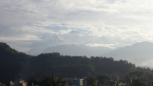
 Viewing the Annapurna Mountains from the Hotel
We took these pictures from the rooftop of our hotel in Pokhara, Nepal. You can see the 8,000 metre tall, snow-capped peaks of the Himalaya's in the distance.Today we woke up at 5:30 and got ready to set off from Pokhara on a tea house trek in the Annapurna mountains. The Annapurna mountains are a branch of the Himalayas. We were disappointed yesterday that it was too cloudy to see any of the snow-capped mountains around Pokhara. Today our guide, Devman (Dave), knocked on our door about at 6:30am to tell us to come to the rooftop to see the mountains. Although not perfectly clear, we could see some of the high snow capped peaks of the Himalayas from there. It was so cool — they are just so high and very impressive. Makes me sad that we weren't here in October when you can see them all! In any case, we'll take some view instead of none. After breakfast at the hotel, we were driven through the mountains to the starting point of the trek, Naya Pol (New Bridge). On the way we picked up a school boy that we had to drop off at a school high in the mountains (he had been visiting his grandmother in Pokhara).
The drive was just beautiful. It took an hour and a half and we could see some

 Viewing the Annapurna Mountains from the Hotel
We took these pictures from the rooftop of our hotel in Pokhara, Nepal. You can see the 8,000 metre tall, snow-capped peaks of the Himalaya's in the distance.of the snow capped peaks, but also lots of the green treed mountains as we wound our way through them. Even though the clouds created a ceiling that made it difficult to see the high mountains, it was very easy to see the lower green mountains with villages at all different levels on the mountainsides, and terraces with flooded rice paddies as well.
When we started the trek, in a small town called Naya Pol, it was somewhat sunny and very warm. From here we walked along a path that was sometimes rocky, sometimes muddy and sometimes steps, crossing over rivers. The countryside was amazing; tons of little houses embedded in the mountainside, rivers, waterfalls, rice paddies, water buffalos, corn fields and other vegetable fields, too. There were also lots of guesthouses and snackbars for trekkers. It was really nice for the first 2 hours or so until we had lunch at one of the many restaurants along the way.
I have to admit, I was very worried about the leech situation. This is the trekking off season because it is monsoon season in nepal and that brings frequent rains and also a ton of leeches. To me

 Viewing the Annapurna Mountains from the Hotel
We took these pictures from the rooftop of our hotel in Pokhara, Nepal. You can see the 8,000 metre tall, snow-capped peaks of the Himalaya's in the distance.the leech part seemed like the most unpleasant part. However, we only saw a few leeches and to be completely honest, i was just so tired and soaked to care at all about the leeches. Apparently tomorrow is a bigger leech day so we'll see.
Actually what I should have been more worried about is not the leeches, but the bees. Or hornets, or wasps — actually we're not actually that sure what it was, but something got me (Elysia) good! We had just crossed a bridge and all I saw from the corner of my eye was this black thing coming toward me at full speed. I kind of liken this to a thunderbolt coming out of thin air and zapping me on the elbow. Whatever it was, it hurt really bad!!! Apparently it was bee-like but orange and actually bit me. My arm swelled up instantly and it was very painful. We were worried for a moment because I have never been stung by a bee so we were concerned that maybe I have a prophylactic reaction to bee stings...but I don't and I'm good. It just hurts. That happened when I had taken my long sleeve

 Viewing the Annapurna Mountains from the Hotel
We took these pictures from the rooftop of our hotel in Pokhara, Nepal. You can see the 8,000 metre tall, snow-capped peaks of the Himalaya's in the distance.shirt off for not very long because I was hot, but I immediately put it back on.
After we ate lunch (Mike had the Nepali traditional Dal Baht (rice, lentil soup and potatoes) for lunch, which is supposed to give 24 hour power, and I just had some bread because I wasn't feeling too well), we continued along the path. Unfortunately about 2 minutes after we set off again, it started raining. And that was pretty much how it was for the next 3 hours (with a few rain rest periods). The rain was so heavy, it didn't take long to have us fully drenched. We wore raincoats and a moomoo-type poncho on top of that to cover our bags that had their own covers too. These protections lasted awhile, but not the whole time. As we made our way along the mountains, the rain leaked through our fake Nepali covers and eventually seeped through our rain jackets, and even our Gortex hiking boots. It soaked us to the core.
We continued to trudge along pathways with the water flowing beneath us. We saw a few leeches but Dave was the only one who got them on him

 Viewing the Annapurna Mountains from the Hotel
We took these pictures from the rooftop of our hotel in Pokhara, Nepal. You can see the 8,000 metre tall, snow-capped peaks of the Himalaya's in the distance.— that was because he was wearing sandals. After awhile I got so tired, I stopped caring about them anyways. We had a rest stop at one point in our journey because the rain got so bad. We thought we'd try to wait it out in a snack shack. It got a bit better but not much.
Our final destination for the day was supposed to be in a town called Tikhedungga (means rock wedge in the local language), but we collectively decided that since we were already wet, it was a better idea to keep going to the next town, Ulleri to stay there for the night. The guide told us it was only an hour and a half longer but it would be much easier in the rain and at the end of the day instead of first thing and in the bright sunshine. We thought why not, we can dig deep and that way tomorrow is easier. Well, the last part between Tikhedungga and Ulleri was a killer!!! Basically it was just stairs straight up the mountainside. We were already really tired and getting up those stairs between villages was exhausting to say the least. It

 Viewing the Annapurna Mountains from the Highway
This picture was taken during our drive from Pokhara to Naya Pol (where we started our trek). Look between the clouds to see a massive mountain "peaking" out.only rained for part of the way up at least. Unfortunately, the water was flowing down the stairs in such a great volume, our shoes quickly became flooded.
This video shows the view at the entrance to Tikhedungga - the rain let up for a minute, which was nice.
Tikhedungga is a very nice town, even in the rain. Here's a video Mike shot while walking through the village:
Here's a little video of us crossing a bridge just after leaving Tikhedungga:
When we finally arrived at Ulleri, it was the greatest feeling. The guide gave us a choice of hotels, but Mike was keen to choose the first hotel in the village that had toilets, so that we could stop. They at least had some private rooms with European toilets (better than the holes we were using as we trekked). The hotel was probably the most simple one I've ever stayed in — almost like sleeping in a converted barn. The washroom was makeshift and the floor was just cement. In any case it was fairly clean and we were exhausted. The place did have beautiful views

 Our Climb for the Day
This graph was produced by the GPS logging App Mike used in his iPhone. It shows how we climbed through the day.of the surroundings.
After we settled in, we ate dinner in the hotel's restaurant (rooms are cheap if you buy the food. They make their money off the food. Because we had the bathroom, the room cost us an expensive on-mountain price of 600 rupees, approximately equivalent to 6 Canadian dollars. This was about the same price for dinner). We played a bit of Dutch Blitz while we waited for dinner (service in Nepal is slow, but the food is cooked special for you), but we retired to bed really early because we were so exhausted (around 8).
Today's Trek by the Numbers:
Mike has been tracking our trek with the GPS.
Starting Elevation: 905 m (2,969 feet)
Starting Place: Naya Pol, Nepal (28.300720 N, 83.769501 E)
Ending Elevation: 2,033 m (6,670 feet)
Ending Place: Ulleri, Nepal (28.356646 N, 83.735672 E)
Total Vertical Climb (included all the ups in the ups and downs): 1,650 m (5,413 feet)
Distance Traveled over Ground: 9.95 km (6.18 miles)
Pace: 30:40 minutes/km (49:21 minutes/mile)
Hiking Time: 5:05:17
Calories Burned: 3,638
(Note: We started the trek in Naya Pol, but forgot to start the GPS logger at the start. We
started the logger near Birethani, Nepal (28.309214 N, 83.775360 E). The above numbers only include the time after we started logging.)
You can see a detailed and interactive map of our route, along with a 3D video of our path here:
Interactive Map and Video of Route
A Bit About Our Guide
Today was a fantastic day, in no small part to our wonderful guide. We thought we would share his contact information in case any other travellers are planning a Nepal trek and looking for a guide. If you are, get in touch with Devman Tamang - he will take care of you and knows all there is to know about trekking in Nepal and all of the different routes. We would strongly recommend him, without any hesitation! Here is how you can get in touch with him:
Devman Tamang
Email: info@himalayanepaltrek.com or dmanamrita12@gmail.com
Devman's Tour Company Website: Himalayan Nepal Trek Devman's Facebook Page Telephone: +977 9849278906
Advertisement
Tot: 0.06s; Tpl: 0.013s; cc: 11; qc: 31; dbt: 0.0182s; 1; m:domysql w:travelblog (10.17.0.13); sld: 1;
; mem: 1.1mb


Chris
non-member comment
Well you are in Asian leopard cat country. Wouldn't it be cool to see the foundation wild cat of the Bengal breed in the wild?