Advertisement
Published: December 2nd 2011

 KM 82
KM 82
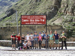
Inka Trail starting pointI made it! 4 days and 3 nights on Inca Trail, some 40 km between mountain tops and vallys, altitudes from 2400 to 4200 m. One of the best experiences so far.
Starting from checkpoint KM82 on the road to Cusco and trecking on the first day to Wayllabamba campsite, 2980m, a good 5 hour walk to start with.
Everything was organised, breakfast, lunch, 5 o'clock teatime, dinner and snacks inbetween. Local porters carried all the necessities in advance - tents, food, gastanks etc. + our backpacks which were waiting when we tourists finally arrived. We only followed the quides and tried to survive the terrain carrying our daypacks with essentials needed for the day.
Day 2 was the real challenge. From Wayllabamba we headed to Abra Warmiwanuska "Dead womans pass", 4200m, 6 km forward and 1200m upwards! Coming from sealevel altitudes 3000m and up are really tough - a constant headache and feeling of powerlessness is the price I had to pay but the landscapes and sceneries paid it multiple times back. After the pass we walked to the campsite in the valley.
Day 3 started with climbing back to 3600m and a days walk in
the jungle like "cloud forest", and after the peak Phuyupatamarka, 3620m, we lowered down to Winaywayna campsite at 2700m.
Day 4 was the climax - Machu Picchu ! Early wakeup at 3 o'clock, to be sure to be one of the first groups to be let in through the gates opening at 5:30 and actually we were the first. From the gate there was a good hours walk to the sun gate from where we could see Machu Picchu at sunrice.
From Machu Picchu we took a train to Ollantaytambo and bus from there back to Cusco where I am waiting now for the start of my next adventure to the Amazon jungle.
All in all Inca Trail gave us a chance to experience what travelling has been here at the ancient days and also we got to see few more Inca ruins that we ever could have seen moving with public transport. If you ever have a chance - do it!
Advertisement
Tot: 0.042s; Tpl: 0.011s; cc: 7; qc: 24; dbt: 0.0241s; 1; m:domysql w:travelblog (10.17.0.13); sld: 1;
; mem: 1mb

 KM 82
KM 82


Captain Sa
non-member comment
No pain no gain
seems that your physical tracking efforts are really paying off with fabulous sceneries and unforgettable experiences. Keep on going...