Advertisement
Published: March 4th 2006

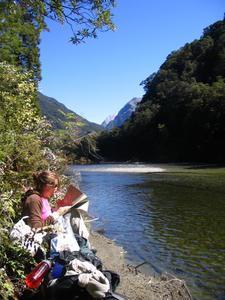
 Michelle with Map
Where are we going anyway?The last few days Michelle and I were on the Milford Track here in Fjordland. The track itself starts from the top of Lake Te Anau and follows the route that the original explorers took trying to pass a pass from Te Anau to Milford Sound. It's been called "The Finest Walk in the World" but in the interest of full disclosure, that was said around 1950 I think. It's still a fantastic "tramp" as the kiwis call it; probably one of the best in the world. Here's a quick summary of the 4 days:
Day 1
The first day is really short and easy. You only travel 5 km on easy terrain. I think they make it easy for the day hikers that are allowed on the trail at this point. You have to take a 1.5 hour boat ride just to get to the trailhead. Since there is a limited number of hut bunks, you have to book ahead of time to do the whole trail. On day 1, the weather was unbelievable. Not a cloud in the sky.
Day 2
In case you don't know, Fjordland is a temperate rainforest. We found this out on day

 Day 2
Day 2
The rain-resistant boots; they do nothing!2. It rained all day, heavy rain at times. The rain itself wasn't a problem but we were hiking in a fjord which is a river valley between 2 towing mountains on each side of you. The terrain is really fantastic to see and photgraphs don't do it justice. Anyway, there were several sections of the "trail" that were flooded by the river or by waterfalls that streamed water down from the mountains. At first, the flooded sections were up to our ankles but we hit a section were the bridge we had to cross was flooded up to our knees. See Michelle in photo. There was another section where the river flooded the trail up to our mid-thigh. The hut ranger had to stand by that section and lead everyone across so that we stepped on the bridge and didn't fall in. One guy in our group actually lost balance in flooded section and was swept away for a few feet but he managed to grab onto a tree. He was fine but his camera got soaked. The day was about 16 km of hiking with a moderate climb.
Day 3
Day 3 is the mountain pass. It
was raining but not as bad as the day before. We had to climb 550 meters in elevation and then descend 1km in a 14 km stretch of trail. Funny enough, day 2 was more dificult mostly because of the rain and floods. I really wish it was a clear day today because the views would have been amazing. As it was, we saw mostly clouds and a little bit of snow at the peak.
Day 4
Day 4 is a 18km day with fairly easy terrain. Not much to talk about. The weather was fine and that made the walk reasonably easy. After we reached the end there's a sign with the trail-end covered in boots. I guess it's tradition to hang up your crappy boots if you don't want them any more. The tramp ends at Milfor Sound so we took a cruise through the sound. It's an amazing cruise. Mitre Peak is the tallest mountain in the sound and it extends 1 mile in the air which is about how deep the water is in the sound. the mountains are right on top of you.
We're relaxing in Te Anau today and soon to be leaving for Queenstown. Till then...
Advertisement
Tot: 0.07s; Tpl: 0.011s; cc: 6; qc: 45; dbt: 0.0466s; 1; m:domysql w:travelblog (10.17.0.13); sld: 1;
; mem: 1.1mb

 Michelle with Map
 Day 2
Day 2