Advertisement
Published: December 3rd 2005

 Survivors!
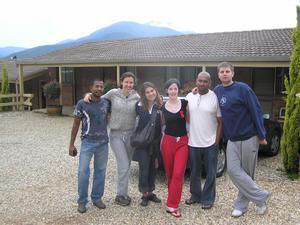
Don, Jo, Flo, Lou, Lucky, Vedran and Mt Bogong lurking in the backgroundI'm writing to tell you all about my huge adventure at the weekend, not
quite a extreme as Blair Witch but heading there!
Basically last Friday night six of us left Melbourne and headed east
to Mount Beauty so that we could climb Mt Bogong (the highest mountain
in Victoria) the following morning. After 5 hours of being squished in
the back of a car we got to our motel in the early hours of Sat morn,
had a few hours sleep and then set off for our 8 hour hike. V.
sensibly we went to the info centre to get a map first, but it wasn't
opened yet. However, the woman who works there came along, without
the key! We told her where we planned to go (up the staircase and dwn
Eskdale spur for those of you who are interested) and she assured us
that the track was well marked and we didn't need a map......do ye see
what's coming yet???
The track to the top of Mt Bogong was well marked (but a v. steep
climb) and we got there in the afternoon - some of it was a bit of a
struggle as one of the guys got really bad spasms in his legs, but
thankfully was ok once he got to the top. Then after some lunch we
started the descent - even had a snowball fight on the way, yes it's
the middle of summer in Australia and there's snow!! We took the most
obvious path down - also known as the wrong one! This was around 3pm.
Everything was fine, although we did remark on how we hadn't made much
of a decent after some time walking. We kept going and then we came
to point just past Cole's cabin where we had to choose between to
tracks, which were signed but neither really meant anythign to us so
we choose the one which appeared to be going the right way. And off
we went. Then something bad started to happen - we started to climb
again. Not good. At 6pm we were still going up and everyone was
beginning to realise that we were a bit lost. We decided to keep
going as a path must lead somewhere, and it was the Alpine pass.
However, all it seemed to be doing was skirting over the mountain
range. But we had no choice but to keep on going. And we knew we
were on a used track cos every so often there was freshish horse poo!
Eventually we found a track off this one which led downwards. We were
all a bit anxious by now about getting down before dark, but
eventually this new track led to one which had once been used by cars
(or more likely 4WDs!). We were so happy to find this - it was
leading down too. We walked along this track for ages, and even
though it got dark the moonlight was enough to guide us but we were
loosing hope of getting down before it got too dark and our feet were
getting sore and tired. We had water and a bit of food but not that
much. After a couple of hours of walking on this track, passing thru
the area burnt by the 2003 fires including a burnt out hut we came to
a place where this met three other roads and realised we'd been on the
Mulhauser track (yeah, it didn't mean much to use either, but we noted
the name in case we ever got reception on our mobiles and had to let
people know where we were). This junction was at a timber logging
place and we took the largest road off the junction. It was a kind of
sandy road. Little did we know what we were embarking on. We walked
on this never ending road for hours - it would be straight for a bit
then curve to the left and when we'd go roudnhte corner there would
just be another one to the right. It went on and on and on like this
- all perfectly symmetrical curves and we felt like we were going
round in circles. We were soooo thirsty but by now water was
beginnign to run low so we had to last as long as we could without it.
Our feet were so sore that most of us were walking with the aid of
sticks by now and at one stage I jsut had to lie down on the road to
feel some other part of my body other than my feet. Then a wonderful
thing happened, the vegetation suddendly and the road too. It wa
really steep and led to this bridge over a river. We were delighted
and thought we were nearly out of the mountains, but alas the road
just went up again! And up and up and up. The wind started to pick
up and we were exhausted so decided to stop and try and sleep for a
bit. It was midnight by this stage.The 6 of us lay in a line on this
sandy dirt road on top of ants, rocks and god knows what else. After
two hours of this no-one could sleep as it was far too cold and noone
could relax enough we started off again. As we went round the next
corner we screamed with delighted - there was another junction, with a
HUGE road sign. We were all jumping up and down with new foudn hope
screaming, it's a real road, it's a real road! Then we read the sign
- one town was 70km to the left another 80km to the right, and Mitta
Mitta 29km to the right. Amazing feeling to know we were near-ish to
a town and started off again. We reckoned we could make it in
6-8hours. The first hour of this walk was ok but then it got really
bad again and we had to stop a few times. At 3:30am we all had to lie
down on the road again to rest. We were dying, but had hope of
getting to the town sometime soon. Yet again we set off saying we
wouldn't rest again till 5am. As we walked down the road trying to
stay in the middle of the road so as not to fall over the edge and our
eyes playing tricks with us as we thought we saw lights, things moving
and following us.
Then we saw another sign - for a campsite. All we could think off was
the possibility of water at the campsite nd two of the guys went to check
it out as the rest of us rested. Next we could hear them shouting
'cars' and 'people'. It took a while to register but realised that
there were people at the campsite and they could help us and we were
finally safe. The feeling of relief was unbelieveable. We went and
woke them, making noise and saying we needed help. Turned out it was
a group of people from the Wagga Wagga 4WD club. They all got up and
drove one of the guys to Mitta Mitta so that he could call the police
(turned out they knew we were missing as the guy in our motel had
reported us missing to the police). They made us tea, coffee and fed us - this is
all at half 4 in the morning! Then they gave us their beds to sleep
in while they sat in the jeeps. There were so nice. In the morning
they gave us all a full breakfast - egg, mushroom, bacon, spaghetti
etc. It was divine - we just ignored the fact that we could barely
walk.
Later the convoy of five 4WDs drove us all back to Mountain Creek
where we had started off our trek and left the car. This was 40km
away! We obviously took the roads through the mountains which was a
really great experience - took an hour and a half to get back. The
last 7km took half and hour!! We were so so so happy to see the car
again and be safe.
The police came to talk to us when we got back to the motel and we
realised we'd first gone wrong when leaving the top of Mt. Bogong.
Apparently a while ago a girl did the exact same thing and took the
path we did, but she was lost for 2 days. We were lucky to have a
group to keep each other going, and even the weather was kind to us.
There was a thunder and lightning storm - but that was in the
distance.
Could barely walk yesterday - couldn't walk on my heels at all so my
toes ached after awhile and I ended up coming home early form work.
I'm ok now. Legs are just a bit week still.
So glad that it had a happy ending and that no-one was injured. But
as for that woman telling us we didn't need a map, well I think ye
can all guess what I think of her! Oh, we're going to be famous now
too - we're appearing in the next Wagga Wagga 4WD newsletter!
Advertisement
Tot: 0.111s; Tpl: 0.011s; cc: 12; qc: 57; dbt: 0.0561s; 1; m:domysql w:travelblog (10.17.0.13); sld: 1;
; mem: 1.3mb


