Advertisement
Published: March 11th 2014

 The pillars
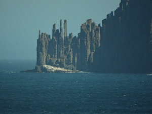
Cape Raoul taken from Maingon BayAfter our very busy day at Port Arthur yesterday, we had a quiet Sunday morning before going to find out what is remarkable about Remarkable Cave. A name like that entices the imagination to create images of stalactites, glow worms and a zillion other things.
There are two things remarkable about this cave.
Firstly, we were able to navigate there without Tommy's help. Now that came about because he did not know where Remarkable Cave is. So we had to rely on good old fashioned map and signpost navigation.
The drive to Remarkable Cave takes you through a couple of sheltered bays that make up the small community of Carnarvon. When Port Arthur was closed (1877) and the Queen ordered that the site be wiped off the map, in typical Aussie fashion the township was renamed Carnarvon, land subdivided, and some of the penitentiary buildings destroyed. However much was retained as there was quite quickly an interest in the historical value of the site.
The first thing you notice as you come over the hill towards Maingon Bay is that the pillar shaped rocks of Cape Raoul quite dominate the distant horizon.
Remarkable Cave is located
at Maingon Bay, which I kept calling Marion Bay, even though that bay is located some 40 ks from here. This is an ocean facing beach and popular with local surfers, though I fear here if they hang too long they will end up on a rocky foreshore.
Although the swell on Sunday was only modest, the rollers arrived making for attractive photography.
The path/steps to the remarkable Cave goes down the cliff face to the landward side of the caves. As you descend you can see the rocky crevice that has the water surging up into the cave. It is not at all clear why this cave has its name as initially it is like most other sea caves. On closer inspection, if you stand towards the right hand side of the viewing platform at the caves entrance, you will see that it creates a map of Tasmania through the shaping of the walls.
A very pleasant attraction just a few kilometres from Port Arthur, but on the seaward side of the land mass.
Advertisement
Tot: 0.063s; Tpl: 0.01s; cc: 12; qc: 29; dbt: 0.0313s; 1; m:domysql w:travelblog (10.17.0.13); sld: 1;
; mem: 1.1mb

 The pillars


