Advertisement
Published: November 18th 2009

 Lake Powell
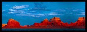
This picture certainly does not do the scenery justiceWell, I backed up my computer while I was in St. George Utah—thank goodness. Unfortunately, I didn’t have another wireless access park until I got back to Texas, then my computer crashed. I lost all the pictures I took in Lake Powell and at the Balloon Fiesta, so I’ll try to describe what I saw as best I can and use some pictures I have copied from the Internet and from a calendar I purchased in Albuquerque.
Lake Powell is the 2nd largest reservoir in the United States and was created by flooding the Glen Canyon area of Arizona and Utah and damming up the Colorado River. The inflow of Lake Powell occurs 186 miles from the Glen Canyon Dam and delivers water to more than 20 million people.
In the late 1800s it became obvious to the Government in Washington that a source of water had to be found for those emigrating into the Southwest U.S. if the emigrants were to stay in the area. The Lake is named for John Wesley Powell who was sent out from Washington at that time to explore the area in search for a suitable dam site.
I stayed in Page, Arizona which is

 Glen Canyon Dam
The bridge was actually constructed in California and transported to Arizona.one of the youngest communities in the United States. It is located approximately five hours north of Phoenix and five hours east of Las Vegas. The town began in 1957 as a housing camp for workers building the Glen Canyon Dam. In 1958, some 24 square miles of Navajo land were exchanged for a larger tract in Utah, and "Government Camp" (later called Page in honor of Bureau of Reclamation Commissioner John C. Page) was born.
On October 15th, 1956 President Dwight Eisenhower pushed a button on his desk in the Oval Office and the first blast which marked the start of construction of the Glen Canyon Dam was underway. The Dam was dedicated by Ladybird Johnson on September 22, 1966. It took 17 years for Lake Powell to completely fill for the first time. At full pool—3700 feet above sea level—the lake would be 560 feet deep at the face of the dam. The red sandstone cliffs make a beautiful backdrop for the dam and lake and make it a popular tourist destination for anyone who enjoys any sort of water recreation.
One of the highlights of my visit to Page was a trip to the Lower Antelope Canyon.

 Antelope Canyon
Such a beautiful and unusual experience, you can see the grooves made by the rushing water.It was stunning. The canyon is on Navajo land and a person can only visit with a Navajo guide. I showed up at the guide office and was immediately loaded into the deluxe transport—an old pick-up truck with two benches installed in the center of the bed from front to back—no seatbelts! Fourteen of us wobbled our way over the 8 miles from Page to Antelope Canyon—needless to say we were “close friends” when we arrived at our destination. For much of the trip we were driving along the river bed left from the annual flood of the Colorado River. The overflow rushes through crevasses to a depth of about 15 feet creating slot canyons, this one is accessible on foot, in the Upper Canyon a person has to clamber down and up ladders.
The canyon has been carved from the Navajo sandstone over the course of millions of years. The narrow passages provide just enough space for a small group to walk the sandy floor - and for the occasional shafts of sunlight to shine down from above. The canyon is so narrow in places that you can easily stretch out your arms and touch both sides.
Advertisement
Tot: 0.41s; Tpl: 0.018s; cc: 14; qc: 64; dbt: 0.2897s; 1; m:domysql w:travelblog (10.17.0.13); sld: 1;
; mem: 1.1mb

 Lake Powell
 Glen Canyon Dam
 Antelope Canyon
