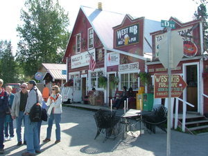
Talkeetna, Alaska


Advertisement
United States' flag
North America » United States
August 7th 2009
Published: August 10th 2009
Edit Blog Post

Nagley'sNagley'sNagley's

Many small shops of this nature line the street in Talkeetna. In this small town there are at least 8 restaurants. This is Nagley's general store . This could be called an "Everything store".
Talkeetna, Alaska is a unique blend of old-time Alaska small town and modern tourist destination. It is an aviation and supply base for Mt. McKinley (Denali) climbing expeditions. Talkeetna has restaurants, lodging, shops, and excellent museums. You can go flightseeing (which is what we chose to do), take a river raft cruise or a jet boat tour up the river.

The National Park Service maintains a ranger station here which is open all year. Their dedication to training and rescue operations on the mountain are to be commended to say the least. These are all volunteers who save many lives of the climbers who collapse on the mountain. All people desiring to climb the mountain must register here and attend classes prior to climbing. Last year around 1200 climbers started the climb and less than half finished the climb. Altitude sickness is a serious concern. The mountain is the highest peak in North America and stands at 20,320 feet, about 6,000 feet higher than the highest peak in the lower 48 states. To view the 4,000 ft. vertical drop of the Wickersham Wall was amazing. Mt. McKinley has a larger bulk and rise than Mt. Everest. The summit of Mt.
The Mostly Moose Gift ShopThe Mostly Moose Gift ShopThe Mostly Moose Gift Shop

Patti's favorite shop. This shop has everything "Moose" except for Chocolate Mousse of course!
Everest is higher measured from sea level 29, 028. Everest's base sits on the Tibetan Plateau at about 17,000 feet, giving it a real vertical rise of a little more than 12,000 feet. The base of Mt. McKinley is actually 2,000 feet elevation, giving it an actual rise of 18,000 ft. To read more about Mt. McKinley, search the internet. So much is available that it would be impossible to cover everything here.

We wanted to flightsee the mountain and land on a glacier. The glaciers have melted so much from the warm weather that landing on the glacier at this late date in the summer was not possible. Large fissures measuring some 50 ft. in width and over 300 ft. deep have formed now due to the warmer weather. We chose to flightsee and land on a mountain glacial lake. What an experience! It was one of the most thrilling things we have ever done. One can only truly say that the camera can never do justice to the beauty the eye can see. These pictures cannot hold a candle to the real thing. You lose the depth perception and the sight of the size of this mountain.
The WildflowerThe WildflowerThe Wildflower

What a nice place.
It was a life changing experience for both of us. I only wish our children and grandchildren could have shared this with us.

We hired an experienced float plane captain, Captain ED, from K2Air in Talkeetna. We took off from Fish Lake heading toward the mountains. It was a sunny day with a little cloudiness over Mt. McKinley. Why is Mt. McKinley so difficult to see? Mt. McKinley rises so abruptly, and so high above its base that the effect is more dramatic here than anywhere else on earth. The mountain is so massive that it generates its own weather systems, much like that of a huge boulder submerged in a river makes whitewater rapids. It is not uncommon for weather systems to obscure the mountains for days or weeks. The winds can get up to 150 MPH and blizzards come out of no where. Temperatures as low as -80 deg. F or -188 deg.F with windchill are not uncommon here.

We took many photos and a video which is now on youtube. The video is of our plane coming down through the snow covered mountains, through Don Sheldon's Amphitheater, through 747 pass, entering Ruth's Glacier area and
The Denali Brewing CompanyThe Denali Brewing CompanyThe Denali Brewing Company

Good Food, Good times, good friends, and good Beer!
landing on Backside Lake, a small lake at the toe of Ruth's glacier. It was thrilling and exciting. We felt as though we could reach out and touch the snow covered glacial walls and the walls of the snow covered mountains around us. The walls of the mountains around us stood 4 to 5,000 feet above our aircraft.
Enjoy the pictures. You will find more verbage there. Remember, if you double click each picture it will enlarge to fill your screen.


Additional photos below
Photos: 20, Displayed: 20


Advertisement

Going for the plane ride !Going for the plane ride !
Going for the plane ride !

That is our aircraft behind us. A DiHaviland single engine Beaver, 8 seater.
Our Captain EdOur Captain Ed
Our Captain Ed

Ed is a wonderful pilot and flies in between the mountain tops as though he has done it all his life.
 The Mountain The Mountain
The Mountain

Once you have seen Mt. McKinley, you only call it "THE MOUNTAIN". When you say, "the mountain", everyone knows which mountain you are speaking of.
 This is 747 Pass This is 747 Pass
This is 747 Pass

The distance between these two mountains is over 400 ft., large enough for a 747 to fly through and have room left over at the wing tips without touching the mountain. We flew through here down to Don Sheldon's Amphitheater , into Ruth's Glacier and down into the lake.
Don Sheldon's AmphitheaterDon Sheldon's Amphitheater
Don Sheldon's Amphitheater

Don Sheldon's Amphitheater was named after Don Sheldon, a famous Alaskan bush pilot who pioneered the technique of glacier landings in and around Mt. McKinley. It looks like you are entering a large snow covered amphitheater amongst the many tall mountains. This is normally where we would land but it is full of deep fissures due to the warm weather here this summer. Also if you look closely, you can see a small cabin built on the top of a rock near the right side, top area of the cliff. At the very end of the cliff , right side, you can see Don's outhouse. He flew the building materials up here in his plane and built the one bedroom cabin and the outhouse himself. Don passed away in 1975 but his cabin still remains on top of this cliff in the middle of Sheldon's amphitheater. Don was famous for operating a ferry service to climbers, hunters, fishermen, and others to places inaccessible to ground transportation. He also played a large roll in mountain rescue for stranded and /or injured climbers. Read his life story in Wager with the Wind, written by James Greiner.
Fissures in the landing area on the GlacierFissures in the landing area on the Glacier
Fissures in the landing area on the Glacier

Here is an example of the fissures which measure some 50 ft. across and hundreds of feet deep. This is caused by glacier melting due to warm weather. The gray matter on top of the glacier is ash from Mt. Redoubt when it erupted earlier this summer.
The Great Gorge of RuthThe Great Gorge of Ruth
The Great Gorge of Ruth

As we entered the great gorge of Ruth's Glacier, the world's deepest gorge, we felt so small and insignificant. The surrounding walls soar 4,000 to 5,000 ft. above on all sides. The ice is 3,700 feet deep, and some of it is more than a thousand years old. If the ice would melt tomorrow, you would witness a spectacle twice as awesome as the Grand Canyon - a gorge a mile wide and nearly two miles high. We stared in awe at mile high spires of sheer granite with names such as Moose's Tooth and Bear Tooth. What an amazing place!
The Great Gorge of RuthThe Great Gorge of Ruth
The Great Gorge of Ruth

Here is another shot of Ruth's Glacier. It was named after Dr. Frederick Cook's stepdaughter. The glacier moves at the rate of 3.3 feet per day.
Two Glaciers MeetingTwo Glaciers Meeting
Two Glaciers Meeting

These are not tracks from automobiles, snow machines, or any other type of vehicle. This is the glacier moving downhill at the rate of about 3.3 feet per day. Two glaciers meeting and joining together on their trip downhill.
 We are landing where? We are landing where?
We are landing where?

YOU MUST BE KIDDING ! We are landing on this tiny little lake ! Yep, and we did ! Amazing !
And here we are !And here we are !
And here we are !

Looks like we are landing on this glacier instead of the lake ! Nope, we made it to the lake! Never a doubt.
Patti and Ed Patti and Ed
Patti and Ed

Ed landed the plane, taxied back to the edge of the lake where we disembarked the aircraft, walked around on the glacier edge and enjoyed the magnificent scenery for a while before departing. The lake was not at the end of the glacier and it was like gravel as the ice carries the snow and ice downhill it picks up pieces of the granite cliffs on it's way. The glacier actually continued downhill from the lake for several miles. Glacier lakes are mostly cement gray in color but very rich in nutrients.
 Taking off for home ! Taking off for home !
Taking off for home !

We are taking off headed back to Talkeetna! Travelled down Ruth's Glacier the full distance from top to bottom, entered the lake at the toe of the glacier and then took off from the lake. Less than 1% of the people in the world today have this experience. What a day !
 Ed's home - Fish Lake Ed's home - Fish Lake
Ed's home - Fish Lake

We are back safely on the ground at Fish Lake and Ed can park the plane safely in it's spot.
 Home Again Home Again
Home Again

Here we are back on Fish Lake!


Tot: 0.247s; Tpl: 0.015s; cc: 6; qc: 51; dbt: 0.1287s; 1; m:domysql w:travelblog (10.17.0.13); sld: 1; ; mem: 1.1mb