Advertisement
Published: February 10th 2013
More photos at:
Picasa

I got up with the truckers and headed back south a little further, then up the Hoh River valley. Along the way (actually, while I was waiting for the park gate to open at 8AM) I was able to answer a question I had been wondering about. If you look at a map of Olympic NP, it looks not entirely unlike someone took a bite out of the west side of the park. The large NPs are often surrounded by larger NFs, and Olympic is no exception, but the NF is also absent from this bite. The bite doesn't look to be all that populated (it actually looks nearly completely unpopulated), so I was curious what was going on there. While I was waiting, I stumbled upon a map that showed who owned all the land in Washington. It turns out that pretty much the whole bite is owned by the state as a Natural Resource Conservation Area. Logging is pretty big important on the Olympic Peninsula, but I couldn't find a clear indication if logging was permitted in NRCAs or not (it seems like not, but I didn't find anything that said it outright). In the end, I did a few short nature hikes in the Hoh area but I didn't spend very long there as there weren't many day hike options.
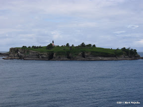
Cape Flattery Light
From there I headed back north, made a quick side trip to Rialto Beach to look at more sea stacks, then headed for Cape Flattery, the northwest most point in the continental US (it falls just short of being the westernmost point). The road to get out there was slow, narrow and winding, much of it right along the Strait of Juan De Fuca, only to find out when I got out there that non-tribe members (it's on the Makah Indian Reservation) have to by a recreation pass to do basically anything on the res. Thankfully it was only $10/year, but it would have been nice to know about before hand. Anyway, the hike out to Cape Flattery and the cape itself were quite nice. Once I was done at the cape, I headed back toward to park and camped At Sol Duc. Along the Sol Duc road, I stopped at the Salmon Cascades to take a few pictures. After setting up camp, I hiked out to Sol Duc Falls on the Sol Duc River for some more waterfall pictures.
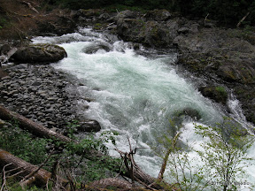
Salmon Cascades
Sol Duc Falls
Advertisement
Tot: 0.126s; Tpl: 0.009s; cc: 5; qc: 45; dbt: 0.0383s; 1; m:domysql w:travelblog (10.17.0.13); sld: 1;
; mem: 1.2mb


