Advertisement
Published: September 2nd 2009

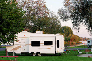
 Moses Lake Cascade Campground
A nice city campground for an overnight in Moses Lake.Day 1. We left the homestead Monday morning by 10:30 a.m. After recruiting friends and neighbors to watch over the house, we set the alarm, crossed our fingers, hitched up and headed out.
We are headed east from south Puget Sound to the Black Hills and Badlands of South Dakota; through central Washington State, the panhandle of Idaho, a bit of Montana, into Wyoming and the Devils Tower, and into South Dakota.
Our destination for the first day was a city campground on Moses Lake. Along the way, we made at least two rest stops to stretch and move about. Ok; Shaddy had us take a short nap at the first rest stop after lunch.
We are using Delorme Street Atlas to plan our route, and the GPS feature with voice command to execute it. The voice function give us turn-by-turn directions.
“I wonder if she is asleep,” I commented as we neared Moses Lake, WA?
Just in case, Nan read aloud the directions on the screen of our notepad computer that uses GPS to show where we are on a map, and where we are going. The computer is plugged into the 12 volt battery system of the truck, and is placed where we can see the screen on the model console of The Beast. A GPS receive is placed on the dash of The Beast and plugged into a USB port of the computer.
The screen shows where we have been and where we are going, according a route I entered which contains all of the overnight stops on the way to South Dakota. This is amazing.
“Honey, have you seen my purse,” I asked Nan after we pulled into a gas station to fill up at Moses Lake.
“No,” she replied.
So, to cut to the quick, my purse has been lost, misplaced or stolen. Nan is betting on misplaced; it must be in her car which I used to run some errands on Sunday, or was it Saturday?
Lucky for us, I use a pocket wallet for my ID and such, but I keep my credit cards in my purse. Since we both use duplicates of the same credit card, we used her card to fill up the tank of The Beast. And will continue to use it the rest of the trip, unless I manage to misplace it.
So, here we are at Moses Lake Cascades Park on our first night on the road. It feels good to have the first day behind us. After parking the trailer in a desirable spot, Nan mentioned that the back left tire looked like it might need a little air. Since the instructions say to check the tire pressure when the tire is cold, I decided to wait until morning to check the pressure and add any air, if needed. We carry with us a 120 volt air pump.
After supper, Shaddy and I walked about and watched some fellows playing 6-against-6 soccer on a short field. No “englesee” was heard, but what great shape the fellows were in, constantly moving and hustling to keep the ball in play. To their pleasure, I contributed a few “ola’s” for plays made against the goal were Shady and I were watching. They appreciated their crowd of two, especially when we stood and did a wave.
We don’t have wifi access tonight, so I’ll have to post this later. I was able to capture a photo of the moon over Moses Lake with Uncle Joe in the frame.
You can see on Google maps where we camped at Moses Lake:
Moses Lake Campground Map Paddy
Advertisement
Tot: 0.284s; Tpl: 0.015s; cc: 17; qc: 74; dbt: 0.0811s; 1; m:domysql w:travelblog (10.17.0.13); sld: 1;
; mem: 1.3mb

 Moses Lake Cascade Campground
Jim
non-member comment
Hardin
Hey, Hardin is about 25 miles from Ft. Smith where I will be in 3 weeks. A Bighorn Fishing trip with Dick Hauch, my old buddy from my intern days. The Custer Battlefield is worth a stop if you get close. Jim