Advertisement
Published: November 8th 2006

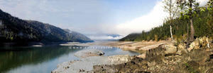
 Rimrock Lake
Pano of Rimrock LakePaddy Mackin of NW Exposures and his two faithful grips (Nan and
Shaddy) made a twelve day photo safari in early October to the east
side of the Cascade Range in Washington State.
The caravan was comprised of a lightweight, fold-out Quicksilver
tent trailer towed behind a four cylinder, sure-footed, all-wheel-
drive Subaru Forester. This combo downshifts from 5th to 3rd gear
going up steeper inclines, and sometimes crawls up a very steep
ascent in second gear, often behind of creep of slow 18 wheelers.
The first photo destination on the safari was 5-star rated, 300 foot
Clear Creek Falls, snuggled into a cliff side about 2.5 miles east
of White Pass along U.S. 12. There are only three 5-star rated
waterfalls within the Mount Rainier Region of “A Waterfall Lover’s
Guide to the Pacific Northwest.”
After bagging Clear Creek Falls, the Oly trio looked about for a
campground in the vicinity of Rimrock Lake. This popular lake,
formed by the construction of the Tieton Dam is surrounded by rich
greens of coniferous forest and steep mountainsides. Used for
irrigation in the Yakima drainage, the water level was extremely
low; so low that the waterside campground destination was

 Volcanic Basalt
Pano of Volcanic Basalthigh and
dry; no lake to be seen.
Snug Harbor Resort on the east end of the lake was selected as an
alternative campground for its water view and full hookup
utilities. At this highland lake elevation, it was clear that the
electric catalytic heater would be of great comfort, if not a
necessity, during the night.
After the tent was hand unfolded over its accordion-like aluminum
frame and snapped in place to the ten foot trailer box, it was
discovered that the wiring had shorted out on the positive side of
the trailer battery that powered 12 volt lights inside the trailer.
The wires had melted. There were no twelve volt lights in the tent
and the water pump was inoperable. Flashlights saved the night.
“Burr,” someone exhaled in the darkness, under a layer of four
blankets. The wind had picked up and a patter of rain drops soft-
shoed on the canvas top of the trailer. “Burr,” again someone
shivered from his position next to the canvas sidewall of the tent.
Shaddy and Nancy were snuggled with two blankets on the warmer side
of the bed nearer the electric heater.
The next day, during

 Dry Falls
Pano of Dry Fallsa scenic drive with photo opportunities to
Yakima, two electric single bulb lights were acquired at a Target
which would illuminate the tent trailer at night.
“Burr,” someone echoed during the second night at Snug Harbor on
Rimrock Lake.
The next day, driving through Othello, on the way to Potholes State
Park, a second catalytic heater was acquired. Paddy volunteered to
go into the store and make the purchase, and returned to the car
with a satisfied grin.
“The computer says to turn left in about a mile.”
About a mile later, “We are supposed to turn left here.”
“There is no road to turn on; it is some kind of path through a
pasture!” she worried.
“The computer says we missed our turn.” He suggested.
And this is how it went. Nan made a rule that she could override
the computer. During a lunch stop, Paddy reset the preferences on
the computer to make it select paved roads only; no paths, trails or
unimproved forest or meadow trails allowed. To help find
photographic sites, Paddy had acquired a GPS gizmo that connects to
his notebook computer, and which provides real time driving

 Blue Lake
Pano of Blue Lake, south of Dry Fallsinstructions to a destination. With preferences limited and its
attitude adjusted, the computer selected the longer way to Potholes
State Park with no suggested shortcuts on unimproved roads.
Much of the east side of the Cascades in central Washington looks a
lot like west Texas; sage brush and all. Most amazing is how the
grounds of state parks are carpeted lush green grass. Industrial
grade sprinkler systems turn the desert into an oasis. No wonder
Potholes Reservoir seemed to be at a low water level.
“Potholes” refers to the many glacial depressions in ancient sand
dunes. The potholes and small islands of the reservoir comprise one
of the best locations in Washington for birding. The best birding
is from March through October; Sandhill cranes and waterfowl in late
February, raptors in April, Sage Thrasher, Lark Sparrow, Burrowing
and Long-eared Owls and shorebirds in May. With the August reservoir
drawdown, the exposed mudflats attract shorebirds such as a variety
of sandpipers, stilts, plovers and curlews. Few birds greeted the
Oly trio during our visit to the area.
Onward to Dry Falls and Sun Lakes State Park along the Lower Grand
Coulee. As the name suggests, Dry Falls no

 Dry Falls State Park
Pano of campground at Dry Falls State Parklonger carries water,
but is the remnant of what was once the largest waterfall known to
have existed on earth. Viewing the 3.5 miles of sheer cliffs that
drop 400 feet, it is easy to imagine the roar of water pouring over
them. (Niagara Falls by comparison, is one mile wide with a drop of
165 feet).
The falls were created following the catastrophic collapse of an
enormous ice-dam holding back the waters of what has been
named "Glacier Lake Missoula". Water covering three thousand square
miles of northwest Montana (about the volume of Lake Ontario) was
locked behind this glacial dam until the rising lake penetrated,
lifted and then blew out the ice dam. The massive torrent (known as
the Missoula Flood) ran wild through the Idaho panhandle, the
Spokane River Valley, much of eastern Washington and into Oregon.
There was only one other camper in the luscious, green, full-utility
serviced spaces of this state park, and they were out of sight on
the far side of the campground. The two night stay was relaxing and
the catalytic heaters kept the inside of the trailer comfortable at
night. “Dang it’s hot,” someone nearer the two heaters complained

 Barn and Fall Colors
Barn along WA Hwy 20, west of Winthrop.during the night.
Hot trail cakes from the griddle is a favorite breakfast while
camping on the road. Nan prefers her batter clumpy, so she cooks
first. Paddy stirs the remaining batter a bit and flips his own
jacks. Nan cooks her cakes at what Paddy calls silver dollar size,
and Nan argues rightly so that they are larger than silver dollars.
Paddy agrees, but insists on using the silver dollar metaphor.
Paddy cooks his cakes cowboy sized; big and round. He thinks Nan
doesn’t cook her silver dollar trail cakes long enough before the
first flip. Paddy browns his cowboy jacks range-style before
flipping.
Before the far away calls of coyotes completed their echo off the
high over hanging curtains of volcanic basalt, Shaddow had climbed
atop Paddy in the darkness, at full alert. Shad is no stranger to
the call of the wild; a familiar chorus of howls and yelps at home
at the edge of the Black Hills. This faithful boy, secure atop
bedrock, is ready to serve, protect and defend.
Two days later, the Subi-Quicksilver tandem was spied crossing
Roosevelt Lake on the small ferry Columbia Princess between
Inchelium and Gifford in northeast

 Washington Pass
Pano of glorious Washington Pass on WA Hwy 20.Washington along Hwy 25.
Campgrounds in the Twin Lakes area looked better on paper, so the
expedition continued up the west side of the Columbia River to
Curlew Lake State Park, north of Republic, Washington.
During the drive west along Hwy 20, the ascent to Sherman Creek Pass
offered expansive views of a young forest regenerating from a
devastating fire which occurred decades earlier, perhaps the 1988
White Mountain Fire. Thousands of burned-out, sun-scored, limbless
trunks stand sentinel on the mountain sides while a young forest of
hope and determination reclaims the sky.
This northeast area of Washington abounds with scenic drives and
vistas. “Burrr,” someone shivered in the dark. Curlew Lake was
cold at night; below freezing, and the two catalytic heaters labored
through the long nights. Water froze in the hose connected to the
trailer and would only dribble a bit of ice in the galley sink.
For Paddy, the best part of the trip for photography was yet to
come; glorious highway 20 from Okanogan thru Twisp and on to base
camp at warmer Silverline Resort on Pearrygin Lake outside of
western themed town of Winthrop.
The forest rimmed farms and ranches of

 Rainy Lake
Pano of 20 images of Rainy Lake on WA Hwy 20.the Methow Valley are a
prelude to glorious Washington Pass and Rainy Pass. Of all the
fascinating trees that grow in the Pacific Northwest -- among them
the colossal Douglas fir, the broad-limbed bigleaf maple and the
enchanting western red cedar -- none is as curious as the larch.
The larch is one of only two deciduous conifers in North America. It
has needles on what look like typical evergreen trunks and branches,
but like a leafy tree, after a show of color, it drops its needles
in the fall. One of two larch species in Washington, the alpine
larch grows as high in the mountains as any other tree, often in the
most inhospitable, rocky spots in north-facing basins buried by snow
much of the year, such as the elbow of Washington Pass near Blue
Lake.
But the larch's most spectacular attribute is the brilliant yellow-
gold it turns in fall, at times almost illuminated when hit by the
angled autumn sun, a stunning harbinger of impending winter.
The fall colors cascading along the length of Hwy 20 are
magnificent; "gash gold-vermilion." GMH, The Windhover.
Your Oly trio broke camp in Winthrop on a Sunday morning during a
light drizzle and threatening skies. By the time we arrived in
Rockport, it was raining with no apparent chance of improvement. We
didn’t want to have to deal with a completely wet tent camper the
next morning, so we pointed the Subi toward Olympia and headed
home.
Advertisement
Tot: 0.107s; Tpl: 0.015s; cc: 12; qc: 28; dbt: 0.0313s; 1; m:domysql w:travelblog (10.17.0.13); sld: 2;
; mem: 1.2mb


