Advertisement
Published: November 13th 2020

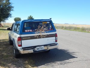
 Clayton picnic area
volcanos & tumbleweedDriving West on US Highway 87 as I crossed from Texas into New Mexico I could see extinct volcanos in the distance. Not far away I drove through Clayton, New Mexico then stopped at a picnic area on the North side of the highway. Of the four historic markers there, my favorite was the Sierra Grande volcano. This is part of the Ratan-Claton volcanic field that extends also into Colorado. I picked up a nice tumbleweed that would follow me for a few weeks. This was also a Southern route of the Santa Fe Trail.
An hours drive West of that picnic area is the small town of Capulin, New Mexico. Just North of that town is Capulin Volcano National Monument, with the large cinder cone clearly visible from the highway. About forty years ago I visited the Capulin Volcano for a wonderful visit. I was shooting with an old 135 mm camera with print film. All my prints were lost to time except three that I included in this blog. The park entrance, and the bottom & top of the road (parking lot) are on the North side of the volcano. The middle of the road up can be

 Clayton picnic area
Historic Marker
one route of the Santa Fe Trailseen from the highway 87 to the South as a white line spiraling up the volcano. Starting upward from the bottom scrub grass ecosystem the trees get fairly large and I saw deer and squirrels while driving. The view from the top was great seeing five states including the Sangre de Cristo Mountains in New Mexico and Colorado. From the top parking lot there are two interesting trailheads. First is the Crater Vent Trail going down six hundred feet down the hazardous loose rock talas to the vent. (Even then I declined cuz if I walked down I may not have made it back up to my truck.) The easy and rewarding walk on the Crater Rim Trail, a bit over one mile long has fantastic views. As I walked the top I got to see the very large breeding population of ladybugs (beetles) on the rocks; that come from far away in the summer.
I really wanted to visit and walk the Crater Rim Trail, but I was late for my big fling in Trinidad later that evening. If I would detour there, I would certainly take over three hours to enjoy the experience. I drove on West
to the City of Raton, New Mexico. I turned North on Interstate Hwy. 25 to Raton Pass at the Colorado State line.
According to Wikipedia Capulin Volcano joined the National Park Service in 1918 by order of President Woodrow Wilson, and the volcano is about 60,000 years ago. The top has an unobstructed view of parts of New Mexico, Oklahoma, Kansas, Texas, and Colorado...and 100 volcanos. This unique ecosystem provides home for 73 species of birds including turkey, osprey, hawks, roadrunners, and hummingbirds. Mammals living there include black bears, deer, cougar, elk, pronghorn, rabbits, badgers, and porcupine.
completed
Advertisement
Tot: 0.168s; Tpl: 0.011s; cc: 15; qc: 46; dbt: 0.0808s; 1; m:domysql w:travelblog (10.17.0.13); sld: 1;
; mem: 1.1mb

 Clayton picnic area
 Clayton picnic area
 Clayton picnic area


