Advertisement
Published: April 27th 2017

 IMG_0579
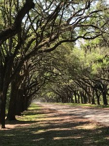
1.5 Mile 'driveway' to Wormsloe, lined with 400 Live Oaks (and Spanish Moss)Wormsloe State Historic Site, Savannah, Georgia
Just because we're getting a little tired and overwhelmed doesn't mean Joan has run out of her Bucket-List Rebellion spirit. Located just 5 miles away (as the woodpecker flies), and 10 miles by car, is a Georgia State Historic Site. Although my bucket list only includes National parks and specifically excludes Historic Sites (because there are just too many of them), that doesn't mean Joan can't add items. And she had read a bit about Wormsloe and wanted to see it. Although we were all hot and tired (this Southern Humidity is becoming a bit overwhelming for us dry-heat New Mexicans), we paid the place a visit. It made it easier that it was just a few miles away.
Wormsloe is a plantation site encompassing the oldest remaining, European built, structures in the State of Georgia. Not much remains of this house, except some foundations, but there are remains of the wall constructed around the place and the grounds are a fun place to walk around.
Wormsloe is the name Noble Jones gave his home, in honor of his Welsh roots. Jones was one of the original settlers of Georgia, arriving with

 IMG_0581
Outer Wall of Wormsloe's Fortlike ConstructionOglethorpe in 1733. He was a carpenter and ended up being assigned a number of other important roles in the community including official surveyor. It was Jones who set up the original plan for the city of Savannah, with its 24 squares. It also appears that Noble Jones is responsible for the plan for Fort Frederica with its grid of homes all in the shadow of the fort. With responsibility, though comes blame, and he was held accountable for the city's slow progress by the Georgia Board of Trustees and even accused of being 'indolent' - a true high crime in those days.
Retreating from that harsh treatment, he moved to this site many miles from Savannah and, by his own sweat and that of some slaves, he built his home on a site overlooking the river. He designed it much like a fort so he could be aware early of any assaults from Spanish troops and defend against them. He died in 1775, before having to make a difficult decision about whether to support his son as a revolutionary, or his King. His son took over the estate and became an important leader in the revolution. The son

 IMG_0582
Another Viewwas the last remaining survivor of the original colonists of Georgia that came over in 1733.
Although the history is interesting here, as it ties together some of the other Georgian sites we've visited, it is also interesting for its geography. Located on a barrier island, as just about everything is in this part of Georgia, we were able from the edge of his property to look out at a huge expanse of marshland. Marshes, although somewhat forbidding, are incredibly interesting places and are important for biodiversity. (I bought a book about marshes, but haven't read it yet. But marshes are significant in most barrier islands, and the Everglades, so I'd like to understand how they work a little better).
As we are looking at all this marsh area, we become aware of how important tides are in Georgia. It is very clear that the area had just been visited by a high tide because, at the edge of the marsh the mud is still very wet. Crabs were even burrowing into the wet clay. We also remember on the road to and from Fort Pulaski, that even over the course of a couple of hours, the marshes

 IMG_0584
Closeup of Tabby - a mixture of oyster shells, sand, lime, and wateron both sides of the road changed considerably, all because of the tides.
Turns out that we weren't imagining it. I'm reading another book about beaches and oceans and there is a chapter about tides. It appears that Georgia has a rather unique position among all of the Atlantic coast states because it experiences the widest swing in tide levels. This has to do with the continental shelf being very wide off of Georgia, extending out as much as 80 miles. The effect of that, when high tide comes in, is to send a huge amount of water inland. So the Georgian barrier islands receive higher and lower tides than any of the other barrier islands.
In itself, that is an interesting lesson in geography, but it gets even more interesting. Yesterday morning, before we headed out to Wormsloe, we received a 'Coastal Flooding Advisory' from the National Weather Service on our phones. Being from New Mexico, which doesn't have any 'coastal flooding' we didn't understand what that meant. So on the way out of the campground, we stopped at the Ranger Station to ask. She explained that, because of the high tides in Georgia, many of the

 IMG_0586
The marsh view from Winsloehighways in the barrier islands can become flooded. She said that we weren't in any danger here, but that some of the islands further out would be experiencing flooding. We remarked that just the day before we had gone out to Fort Pulaski and she replied that that particular highway would likely be underwater at high tide.
We asked how often that occurs and she replied that flooding like that is definitely increasing and it now happens about twelve times a year, when the sun and moon are aligned appropriately. Sea level is on the rise and Georgian barrier islands, because of their unique location, will be suffering early. If you want to see Fort Pulaski, you might want to get there soon! It is likely to be underwater in the not too distant future. (17.1.50)
Advertisement
Tot: 0.291s; Tpl: 0.014s; cc: 6; qc: 45; dbt: 0.1377s; 1; m:domysql w:travelblog (10.17.0.13); sld: 1;
; mem: 1.1mb


