Advertisement
Published: August 5th 2008

 C&TSR
C&TSR
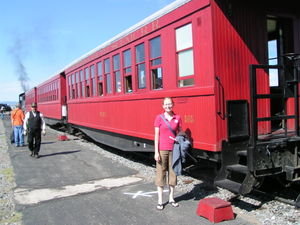
All aboard!!Our first stop on the long leg of our trip was to Alamosa, Colorado. The Cumbres and Toltec Scenic Railroad was the first stop, in nearby Antonito. We took the narrow gauge train 64 miles and crossed the Colorado/New Mexico border 11 times in total, finally ending in Chama, New Mexico. The train snaked through the mountains, reaching a peak elevation of 10,022 feet. The narrow gauge designation is given to trains with a rail width of 3 feet, compared to the standard 4'8", a distinct advantage when making the tight turns necessary to traverse such steep terrain. This resulted in a sometimes alarming amount of rocking back and forth of the railcars. The railway was in its heyday back in the 1880s when it was used to transport mining equipment, mineral ore, timber, cattle and sheep between CO and NM. The C&TSR is a remnant of the Denver and Rio Grand Railway, and is the country's longest and highest narrow gauge railroad, in addition to being one of the best preserved railroad museums.
The Great Sand Dunes National Park and Preserve contains the largest set of dunes in America. After we finished with the railroad, we decided we would

 C&TSR
C&TSR
Preparing to depart the Antonito station.like to camp in the Great Sand Dunes, and attack them in the morning. Unfortunately, we neglected to consider the fact that it was a Friday night, so all of the campsites were filled. We did, however, get to walk around and eat dinner and watch the sun set behind the dunes. As we were walking around, we caught a glimpse of some deer coming out of hiding to graze. We also saw some bear tracks in the soft sand by the river. As we left the park, we came across a doe and her very young fawn (he still had his spots) crossing the road. Luckily, without too much searching, we located a campsite at the adjacent San Luis Lakes State Park. It was already dark out by the time we found the site, and so Cody had to set the tent up by headlight and lantern. He inadvertently parked us right on top of an ant den. Needless to say, the early part of the morning was spent ridding the exterior of the tent of all the ants that decided to investigate our presence on top of their home.
The next morning (Saturday) we set out bright

 C&TSR
C&TSR
You gotta love those old, coal-fired steam engines.and early to conquer the dunes. We set out wearing shorts and hiking boots (stylish, I know) so that we wouldn't get as much sand in our shoes while climbing. It took us a good hour and a half to hike the 1.5 miles with a 650 foot vertical climb, and it only took us 20 minutes to run back down. Afterwards, we walked through the creek barefoot, which felt sooo good, and ate lunch in the parking lot. We then toured the visitor's center, where we got our stamp in our official National Parks Passport, before heading out on our next big adventure, which would turn out to be more than we bargained for....
Advertisement
Tot: 0.077s; Tpl: 0.013s; cc: 12; qc: 29; dbt: 0.0349s; 1; m:domysql w:travelblog (10.17.0.13); sld: 1;
; mem: 1mb

 C&TSR
C&TSR
 C&TSR
C&TSR
 C&TSR
C&TSR


