Advertisement

 Hiking in the Rockies
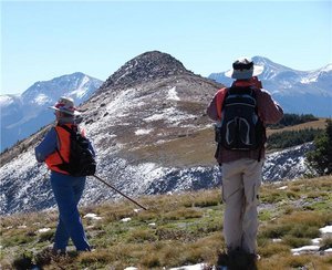
If hiking in majestic mountains is your pleasure, the two mountain ranges surrounding the San Luis Valley will be to your liking. The San Juan and Sangre de Cristo mountain ranges offer some of the most scenic views I have ever beheld.The San Luis Valley, the largest alpine valley in Colorado, offers the best in outdoor recreation, without the crowds. From rim to rim (and oh, what rims!) it exceeds Connecticut in area. And it exceeds almost any western Mountain area outside of Alaska in high peaks.
The valley bottom and the surrounding high mountains hold the secrets of a rich, sometimes tragic history. Hundreds of trails lace this sometimes flat, often very steep landscape. Among the trails, one was recently designated the Old Spanish National Historic Trail. It was a trading trail between Santa Fe and Taos, NM, and Los Angeles, CA.
People question why traders went north to go west. The simplest answer is topography. The flat valley bottom, with available water from the mountains, allowed mule pack trains to pass over the Cochetopa Pass (“Buffalo gate” in Ute) to the western slope with water and pasture along the way. It also served as a route for thousands of Native Americans and early western explorers of Spanish and Anglo origin.
The San Luis Valley is the home of many cultures, some of them ancient. Yet, the permanent population includes only 46,205 permanent residents. The biggest town is home to 8,600 residents, a fine little college, and the only Wal-Mart and MacDonald’s in the huge area. In nearby South Fork, the summer population swells to 4-5 times the number of winter residents.
The area boasts a variety of natural attractions, including about 300 cold-water trout streams and the Rio Grande River. More than 100 small reservoirs and lakes sparkle in the sunshine. A half-dozen hot springs add to the variety, for those who seek soothing.
In this true “Valley High,” simply breathing will clean your lungs. From the valley floor at 7,500 feet (1.4 miles high), the altitude zooms up to over 2.7 miles above sea level. Ten 14,000-foot+ mountain peaks stab into the sky at the top of the valley rim. Many others rise well above timberline. They come in all shapes—flat-tops, huge round tops, and as many forms of ragged as you can imagine. To get that high requires lung-busting hikes or horseback or ATV trips.
The Sangre de Cristos and Culebras on the east, form a “picket fence” of narrow, steep, graceful peaks of mostly sedimentary rocks. This bold, high, narrow range forms one of the most beautiful mountain ranges in Colorado.
To the west rise the jumbled results of centuries of volcanic activity - the San Juan Mountain Range. Ragged, tooth-like ridges (dikes) run north-south and sometimes contrarily. One of America’s largest calderas opened up between the town of Creede and Wolf Creek Pass. It contains many smaller and later eruption cones and calderas.
The huge Rio Grande National Forest offers you 1.8 million acres of varied topography, streams, five vegetation zones, and some of the most intriguing rock formations anywhere. The Great Sand Dunes National Park and Preserve, three National Wildlife Refuges, BLM lands, State Wildlife areas and a State Park, plus plenty of private resorts offer enough opportunities for fun for a lifetime.
Some avid fishermen have been trying for 20 years to reach every lake and stream—in vain. The Colorado Division of Wildlife provides fishing, hunting, and wildlife viewing on 20 small State Wildlife Areas. Some have simple camping facilities.
For wilderness explorers, the Rio Grande and neighboring national forests contain four federal Wilderness Areas, totaling nearly one million acres. The Continental Divide National Scenic Trail travels 200-300 miles along the western rim of the Valley, mostly in the alpine and subalpine life zones. The Old Spanish Trail intersects it at Cochetopa Pass, along with the Canada-Mexico Great Divide Mountain Bike Route.
For diverse and rugged outdoor recreation, the San Luis Valley offers much. Those fit enough to handle the high elevations and rugged terrain will enjoy unforgettable activities and perhaps unravel some of the puzzles that these mountains present.
For orientation, visit the Rio Grande County Museum in Del Norte (www.museumtrail.org), www.oldspanishtrail.org or www.slvheritage.org/heritage.
Advertisement
Tot: 0.088s; Tpl: 0.02s; cc: 5; qc: 43; dbt: 0.0523s; 1; m:domysql w:travelblog (10.17.0.13); sld: 1;
; mem: 1.1mb

 Hiking in the Rockies