Advertisement
Published: August 13th 2010

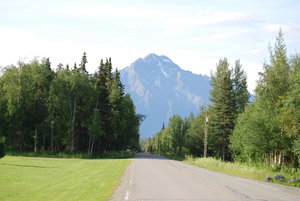
 Pioneer Peak
In the winter, the sun never actually cleared this peak. If you wanted sunshine, you had to drive to Palmer.Mary and Madeline had to leave early to go back to Homer for a wedding on Saturday. So hard to say good-bye to my good friend Mary, and to our almost grandaughter Madeline! Tim cooked us a very yummy breakfast, and reluctantly we said good-bye to him, too. Off we went, all on our own again, a little sadly. We looked in the Denali direction for one last chance, and it was too cloudy. Oh, well, we did actually get to see it that once! (Oh! I forgot to mention that after Janet's plane took off from Anchorage and got above the clouds, SHE got another great look at the peak up above the clouds in the sunshine! Ha!)
As we approached Palmer, the sun came out and it was a beautiful day. We decided to take one last look at our old place. Nancy wanted pictures, and she wanted to know FOR SURE whether that old trailer house there was our old one. It seemed logical, since it wasn't far from the bottom of the hill of our old property. First we drove out to the RV park where we lived for a year when it was a trailer park.
Then we drove out to our place, took pictures and looked at that trailer again. Nancy climbed through the weeds and the bushes and went inside. It was definitely NOT our old trailer. The inside was all different after all. Now we won't have to always puzzle about that! For those who wonder about what happened to the place, we finally sold it in about 1991 and used the profits to build our barn in Carson (which many of you helped with!).
Since it was still a beautiful day when we got towards Glenallen, we thought that instead of waiting until tomorrow to go to Valdez, maybe we should go now and take advantage of the good weather for scenery. First, we asked at the visitor's center if the Taylor Highway to Dawson City was open yet and they didn't know for sure. They said to ask at Tok (possibly short for Little Tokyo, a former name before WWII), and they would
have the latest updates.
So, we turned to Valdez, not knowing what to expect because of the oil disaster, etc. The Milepost said that Valdez was Alaska's Little Switzerland. On the way, we passed a mountainside that had a long area with no foliage that was a natural mineral lick for wildlife. We got out our binoculars, and there we actually saw about five Dall sheep grazing halfway up, not on the mineral lick. We were so happy to see them! Continuing on, we went up the mountain and near the top was Worthington Glacier. Here are the statistics for Thompson Pass by the glacier: record measurements for snowfall were 974 inches for one season in 1952-1953; 298 inches for one month in February, 1953; and 62 inches in one twenty-four period in 1955. Even though the pass is only 2500 feet, it is above the treeline. The landscape was amazing! On the way down the other side, there were many waterfalls, and we even saw a typical moose with water dripping from its head, standing in a pond. We also saw the Alaska Pipeline, making its was to its terminus in Valdez.
Valdez was a wonder. It's a pretty
town and is in a lovely fjord. We were quite taken by it! We found a campground and got set up, looking forward to tomorrow, and glad we made the trip today when it wasn't raining.
Advertisement
Tot: 0.233s; Tpl: 0.019s; cc: 7; qc: 45; dbt: 0.1227s; 1; m:domysql w:travelblog (10.17.0.13); sld: 1;
; mem: 1.1mb

 Pioneer Peak