Advertisement
Published: September 13th 2007

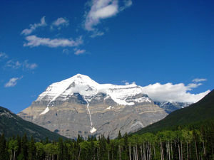
 Mt. Robeson
One of the tallest peaks in British Columbia. We passed it on the way to Jasper. In June, it was fogged in.Monday, September 10, 2007 We were on the road early. There was fog in the valleys and river bottoms which made the farmland picturesque. The fall colors were just barely starting to turn. We suffered some “reentry” getting used to a seeing a number of cars on the highway rather than one or 2 every few hours which was the case in the Yukon and northern B. C. The weather was good, the scenery was pleasant and the driving wasn’t difficult.
We got to Jasper National Park around 4:00 and it was warm. We were amazed to see the number of RV’s and cars. The area is so pretty. We had forgotten in only 2 months! We decided to proceed down the Icefield Parkway, the route that connects Jasper to Banff even though it was another 137 miles and it was after 5:00. We planned to stop at one of the campgrounds on the way. I guess the campgrounds close in early September because none were open.( surprised us because there are so many RV’s traveling which is not the case in the Yukon and B. C.) We were enjoying the ride and the scenery and had resigned ourselves to traveling

 Sunwapti Canyon, Icefields Parkway
This is a view of the canyon, looking down. Couldn't believe all the waterfalls.the entire way when we passed the Columbia Icefields Center (where we had ridden a snowcat on the glacier back in June) and there were a number of RV’s parked in the lot. We thought that was a good idea so we stopped for the night. We traveled 540 miles today and changed time zones (only 2 hours behind east coast now.)
Advertisement
Tot: 0.283s; Tpl: 0.015s; cc: 14; qc: 98; dbt: 0.1748s; 1; m:domysql w:travelblog (10.17.0.13); sld: 1;
; mem: 1.2mb

 Mt. Robeson
 Sunwapti Canyon, Icefields Parkway