Traveling with Friends to El Cielo


Advertisement
Mexico's flag
North America » Mexico » Tamaulipas » Gomez Farias » El Cielo
March 24th 2010
Published: March 23rd 2010
Edit Blog Post

Back in ArizonaBack in ArizonaBack in Arizona

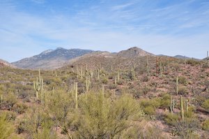
The saguaro cactus defines the Sonoran Desert, just as the Joshua Tree defines the Mohave Desert.
This travelblog covers a lot of distance and time. After leaving our son Nick and the Salton Sea in southern California we headed back to Tucson and the Sonoran Desert. After re-provisioning and some vehicle maintenance in Tucson, we headed south some 40 miles to Patagonia Lake State Park, one of our favorite Arizona State Parks. The plan was to meet Peter and Trudy Brussard and their two dogs, Modoc and Katie, who would be arriving after a quick trip south from their home in Reno, NV. Peter and Trudy travel in a 17 foot Big Foot trailer pulled by a diesel GMC truck. The plan was to travel down the Rio Grande Valley to Brownsville, TX while spending some time at three state parks that Lynn and Jon had really enjoyed in the previous winter. At Brownsville, we would travel to the El Cielo Biosphere Preserve in the state of Tamaulipas, Mexico, sans dogs and trailers. The captions of the following pictures tell the tale.

Note: if you want more information and pictures covering several state parks (Patagonia Lake, Seminole Canyon, and Falcon) than is provided here check several of our travelblogs from winter 2009. Specifically, see Patagonia Lake SP and
Back in ArizonaBack in ArizonaBack in Arizona

A barrel cactus is one of a great diversity of cacti found in the Sonoran desert.
Seminole Canyon SP and Falcon SP.

Terrapass


Additional photos below
Photos: 47, Displayed: 22


Advertisement

Wrightson WildernessWrightson Wilderness
Wrightson Wilderness

The drive from Tucson to Patagonia via Arizona routes 83-82 is spectacular. This shows the view to the west into the Mt. Wrightson Wilderness.
Patagonia Lake, ArizonaPatagonia Lake, Arizona
Patagonia Lake, Arizona

After passing through the small town of Patagonia and following the state park road a few miles you view Patagonia Lake and associated park facilities. The cloud-draped mountain is Mt. Wrightson the highest peak in the area at an elevation of 9453 feet.
Patagonia Lake State Park, ArizonaPatagonia Lake State Park, Arizona
Patagonia Lake State Park, Arizona

Patagonia Lake State Park has emphases on birding, hiking, and boating. As with most state parks these days, the majority of the real work is done by volunteers who receive free accommodations for their RVs as compensation. At Patagonia, some of the duties include conducting pontoon boat tours and bird walks.
ReunionReunion
Reunion

A reunion of good friends (both human and canine) took place when the Brussards arrived during day two of our four day stay. Here we are on the famous Patagonia Lake birding trail, pursuing the Elegant Trogon and other rare birds.
Sonoita Creek State Natural AreaSonoita Creek State Natural Area
Sonoita Creek State Natural Area

One of the beauties of most state parks in the southwest is that leashed dogs are allowed on trails (unlike national parks!). Here we hiked some seven miles into the Sonoita Creek State Natural Area. Just what we needed after too much time behind the wheel!
Birding boat tourBirding boat tour
Birding boat tour

We prepare for a birding boat tour of Patagonia Lake. This was a relaxing trip that allowed close looks at many familiar waterfowl.
Seminole Canyon ShamanSeminole Canyon Shaman
Seminole Canyon Shaman

We left Patagonia for a long, 8-hour drive to Eagle’s Nest RV just off of Interstate 10 in Van Horn Texas. The second leg of this segment was also long and made longer by a flat tire on the Airstream (you recall we also suffered a flat in Gadsden, AL). Eventually we reached the second of our favorite state parks in this part of the country—Seminole Canyon SP. The surrounding land is Chihuahuan Desert and the canyons in this area contain many distinctive early Native American pictographs. The statue next to the park visitor’s center shows a common theme in many of the pictographs—a shaman.
Pecos River BridgePecos River Bridge
Pecos River Bridge

Seminole Canyon State Park is just off of US 90 at the confluence of the Pecos River with the Rio Grande. This shows the high bridge over the Pecos River just a few miles to the north of the park entrance.
Pecos River confluence with the Rio GrandePecos River confluence with the Rio Grande
Pecos River confluence with the Rio Grande

This image is taken from the south cliff overlooking the Pecos River. In the distance, the Pecos River joins the Rio Grande. Creation of the Amistad Reservoir flooded much of the original river channel and the rock shelters they contained. The park was established to help protect the rock shelters and the artifacts they contain.
Hiking the Rio Grande TrailHiking the Rio Grande Trail
Hiking the Rio Grande Trail

Well-maintained trails allow access to many of the canyons and historical sites within the park and were enjoyed by all seven of us.
Fate Bell ShelterFate Bell Shelter
Fate Bell Shelter

Seen here is the Fate Bell Shelter, up Seminole Canyon from the Rio Grande River. This and Panther Cave at the mouth of Seminole Canyon contain some the oldest pictographs in North America, created by native peoples at least 7000 years ago.
PictographPictograph
Pictograph

Some of the pictographs suggest animals, weapons, and other recognizable objects. Some pictographs show mysterious images with unknown meaning. What do you think this image represents?
PictographPictograph
Pictograph

To some, this pictograph seems to suggest a millipede or centipede (or a space alien).
Fate Bell ShelterFate Bell Shelter
Fate Bell Shelter

We left Seminole canyon and its rock shelters with feelings of mystery and awe.
Falcon State Park and damFalcon State Park and dam
Falcon State Park and dam

Our next stop was Falcon State Park, on the shores of Falcon Reservoir, where we stayed for two nights. The park is a special destination for two types of people—bass fishermen and bird watchers. This image shows Falcon Dam, one of many dams designed to prevent flooding and course changing by the Rio Grande. The river flows freely between Amistad and the dam at Falcon.
Brownsville, TexasBrownsville, Texas
Brownsville, Texas

We stayed at the Rio RV Park to the east of Brownsville on the road to Boca Chica beach and the mouth of the Rio Grande. After depositing the three dogs in a reputable kennel (Canine Country Club), we left with Lee Zieger, owner of the RV park and our guide and chauffeur for the four-day trip to El Ceilo, in the state of Tamaulipas, Mexico.
Mango OrchardMango Orchard
Mango Orchard

Aside from a few inspection stations setup by the Mexican army, we encountered few interruptions in the six hour drive to Gomez Farias, the small town near the El Cielo biosphere preserve where we would be staying. We were amazed by the large size of fields and orchards (image shows mango orchard) evident along the roads. Clearly agribusiness was doing well in this part of Mexico.
Sierra Madre OrientalSierra Madre Oriental
Sierra Madre Oriental

While in Gomez Farias, we stayed at a wonderful hotel called the Casa de Piedra. The accommodations were great. This is the view of the cloud forest of the Sierra Madre Oriental from the hotel.
Casa de PiedraCasa de Piedra
Casa de Piedra

This is the view across the garden area of the hotel towards the restaurant where we met for drinks and meals. They make very good margaritas and the food was excellent.


Tot: 0.278s; Tpl: 0.015s; cc: 10; qc: 61; dbt: 0.1431s; 1; m:domysql w:travelblog (10.17.0.13); sld: 1; ; mem: 1.1mb