Advertisement

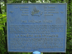
 French River Marker
The Canadian Heritage Rivers System plaque identifying the importance of the French River.Travel from Sault Ste. Marie to Toronto via Hwy 17....Thursday, June 12th.
Crappy day...still misty and foggy from yesterday's rain when I arrived in SSMarie. 17° C Up at 06:00...ready to check out @ 7:30. Filled up with gas at Shell on Great Northern Road. Pulled up to a pump for service and the attendant advised me that the "service pumps" cost more than the self-serve...I splurged.....69.045 L @ $1.499 = $103.50 (1605 km). Txt to Joe to tell him I'm on the road and moving at 07:57 hr.
Stopped in Spanish, ON, at 10:11 hr for a break and a pee. Picked up unusual cans of tea and Lotto tickets for Teri (1801.8 km) Still cloudy and lots of fog...can't see anything of the lake or surrounding area....visibility on the road OK, but not far off it. Back on road by 10:19 hr.
Stopped at French River Rest Stop (Prov. Park?)for break and a pee....12:15 -12:39 hr (1983.5 km). Very nice information centre with gift shop and museum display. Walked out to pedestrian bridge over French River and took some pictures. Back on the road at 12:40 hr....small crash just outside the rest stop...looks like one truck

 Canoe Route to the West Marker
Plaque explaining the importance of the French River in the exploration of Canada. Lots of name dropping here...Brule, Champlain, La Verendrye and even Mackenzie. May have to recommend the addition of Prokopanko to the list of explorers that have passed by...side-swiped the trailer of a semi....side of the trailer ripped open and the other truck overturned in the ditch. Firetrucks and police in attendance, but doesn't look like any injuries as there is no ambulance. Continued on after a short wait for traffic control past the scene.
Nothing much to see along the way....my GPS device not up-to-date with all the new roads around Sudbury...got mad and told me to "Return to the nearest road!" a number of times. Lots of construction on Hwy 17 (twinning), which will be nice when complete. Hit a major downpour just as I was passing by Barrie to head South on the 400....skies just opened up, but didn't slow anyone down. Had to put windshield wipers on high speed, but traffic continues on.
Arrived at Joe's apartment at 15:40 hr (2297.1 km)...called him and he came down to help with luggage and stuff. Spent the night in Joe's Richview apartment.
Friday, June 13th....headed out to Legend store in Innisfil, but rather low on gas...hadn't filled up since SSMarie so stopped in Bradford....66.475 L @ $1.399 = $93.00. Not bad mileage for the old van....onboard computer says 8.8 L/100 km. On to

 Pierre Radisson Plaque
Plaque explaining the involvement of Pierre Radisson and his brother-in-law, Groseilliers, in the development of the Hudson's Bay Company.Legend store and picked up our new boat. Took pics and made arrangements to leave it in their lot until I'm ready to head home...Sat or Sun.
Advertisement
Tot: 0.102s; Tpl: 0.036s; cc: 6; qc: 50; dbt: 0.0528s; 1; m:domysql w:travelblog (10.17.0.13); sld: 1;
; mem: 1.2mb

 French River Marker
 Canoe Route to the West Marker
 Pierre Radisson Plaque


Cam
non-member comment
Speaking of adding a name
Don't forget to add Krep's name, he'll be the one upfront paddling while you drop your line in to fish