Advertisement
Published: October 25th 2006

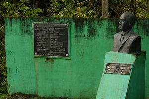
 El Presidente! Sanctuary!
Nature reserve or donated property, keeps the locals in La Paz busy.Forget da Map!
After the weather cleared out, it was time to warm up. Woke up to clearer skies and distant thunderstorms on the Pacific.
Perfect temps, sun peeking out from behind the clouds, burning off the fog and drying the mud. Time to take a drive!
Up the road to LosAngeles Norte and the back way into San Ramon. Hmmm? Which way? Right(dereche)!
Amazed by the valleys and ridges and trees and houses....gotta watch the road too!!! Wanted to get to the top of the far ridge,
but no road, or 'Ya can't get dar from here!", so I kept going....and going...and going....til the road ended at a river! Nope, too deep for the Geo!
There is a beautiful finca down there, in the middle of nowhere. Seems a previous President donated property for a 'bosque', looks like a nature
'Sanctuary!'(for Jared)....inside joke.....see pics...
Turned around went right back the way I came....I know those old farmers were muttering, "Silly gringo, doesn't he know the road ends!"
Again, I say as I pass back by, Buenos! Adios!......noticed the road was almost a cobble stone....river rocks placed such that asphault wasn't needed.
Timing is EVERYTHING! Got

 That is REAL Trouble!
Yes, the wasps are there, and I used TELEPHOTO!out of there and back to the BnB before dark and as a storm unloaded!
The humming birds were back at the feeder, and to our surprise at the blus feeder also. Noted that there are 2, recognizable, coming about every 20 minutes,
so the feeder is nearly empty. Great addition to the entertainment here, for those guests that wake at DAWN and
drink coffee on the patio out front. Its here all day, just sit or chill in a hammok and enjoy!
I got a lesson in local geography today. The MAP is WRONG! YEP, its true! I can testify! and the scale, its questionable as well !!!!!
The location of the BnB is on the northern edge of Los Angeles Sur(not on the map), about a half a mile past the church.
The town of ?Uilia? (on the map)... My lesson was that the town is just across the valley, on the road to Zarcero, just south of the BnB!
Los Angeles Norte(not on the map), is about 1/2 a kilometer up the road behind the BnB. GOT IT?....sorry, ya gotta be here.
No worries though, there is a new 'highway' going through on

 The Ridge, where I couldn't go.
Could not find a road to the other side. The valley was like a crater.that side of the valley.
This road is supposed to be wider, flatter, and built for all the truck traffic going to La Fortuna.
Maybe, it will be shown on new maps, even if its not completed...
Advertisement
Tot: 0.058s; Tpl: 0.01s; cc: 10; qc: 28; dbt: 0.0305s; 1; m:domysql w:travelblog (10.17.0.13); sld: 1;
; mem: 1.1mb

 El Presidente! Sanctuary!
 That is REAL Trouble!
 The Ridge, where I couldn't go.